- Home
- :
- All Communities
- :
- Products
- :
- ArcGIS Pro
- :
- ArcGIS Pro Questions
- :
- How do I identify locations along a path where poi...
- Subscribe to RSS Feed
- Mark Topic as New
- Mark Topic as Read
- Float this Topic for Current User
- Bookmark
- Subscribe
- Mute
- Printer Friendly Page
How do I identify locations along a path where point is visible?
- Mark as New
- Bookmark
- Subscribe
- Mute
- Subscribe to RSS Feed
- Permalink
- Report Inappropriate Content
I have a 50cm DEM with a point on top of a building. There is a path around the area of this building. Which tools do I use to identify where along that path the point is visible? The help lists an example of a viewshed "identifying where a visible along a highway" which is essentially what I am trying to do, but the example doesn't tell me how to use a viewshed in this way.
- Mark as New
- Bookmark
- Subscribe
- Mute
- Subscribe to RSS Feed
- Permalink
- Report Inappropriate Content
Hi Tim Anderson
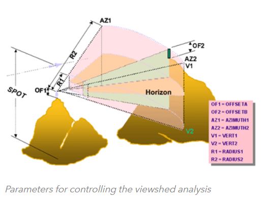
Hopefully I can help, from what you have said you want to identify areas along the path in which you can see the point located on top of the building. I would conduct a Viewshed from the point on the building, adjusting the Vert 1 and Vert 2 values within the attributes of the point and utilising the parameters in which you have set for your analysis for other values such as Offsets and Radius. See diagram below for conceptual understanding of varying parameters the tool uses.
This will then give you the locations along the path in which you can see from the building. Then you can either select points identified or convert the raster into a vector and run confirmatory Viewsheds from the identified locations, once again adjusting the Vert Values. There are many different ways you can tackle this. I conduct the analysis in this order so that if you utilise multiple points on the building you should receive a result displaying highest visibility areas to lowest along the road. Helping your selection process. I hope this has helped answer your question.
Shane