- Home
- :
- All Communities
- :
- Products
- :
- ArcGIS Living Atlas of the World
- :
- Living Atlas Questions
- :
- Living Atlas
- Subscribe to RSS Feed
- Mark Topic as New
- Mark Topic as Read
- Float this Topic for Current User
- Bookmark
- Subscribe
- Mute
- Printer Friendly Page
- Mark as New
- Bookmark
- Subscribe
- Mute
- Subscribe to RSS Feed
- Permalink
- Report Inappropriate Content
I live in Nigeria and work with ArcGIS, i noticed satellite imagery was last updated in Jaji, Kaduna State Nigeria, Nov 2014, in trying to compare i noticed google map is more updated, although with my knowledge in Living Atlas the satellite imagery is periodically updated, why is capturing in Nigeria "neglected".
Solved! Go to Solution.
Accepted Solutions
- Mark as New
- Bookmark
- Subscribe
- Mute
- Subscribe to RSS Feed
- Permalink
- Report Inappropriate Content
Hello and thanks for the question. I was a little surprised with the currency of the imagery for Jaji in your screenshot so I double-checked our Imagery with Metadata web map and the dates I'm seeing are a bit different. The current imagery for Jaji seems to be from November 2015-2016 (e.g. 3-4 years old), which is more what I would expect.
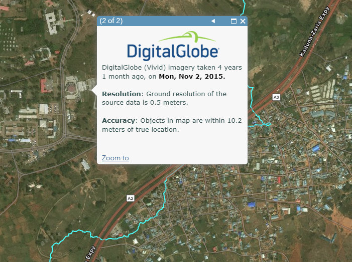
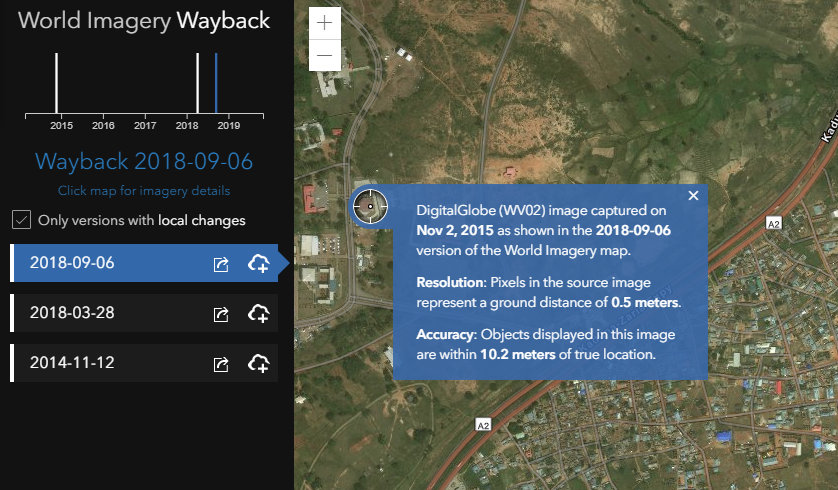
Another useful tool to see the latest and previous versions of our imagery is the World Imagery Wayback app. Looking at this, it looks like we last updated the imagery in this part of the world in September 2018, and there were a couple different versions available prior to that.
In general, our goal for our World Imagery map is to have detailed (source 50cm or better) imagery that is within 3-5 years of currency. We update the imagery on a regular basis with the latest imagery that is available to us. For the DigitalGlobe Vivid imagery that we have for this part of the world, we are now starting to update all of the world with the latest Vivid imagery each year. I will double-check but I expect we will be deploying a Vivid imagery update to this part of the world in the near future. This will likely update the imagery in Jaji to something more recent than above, assuming high quality imagery was captured in the past 1-2 years. As we make significant updates to our World Imagery map, we will be publishing info to the ArcGIS Living Atlas blog site.
I hope this helps!
- Mark as New
- Bookmark
- Subscribe
- Mute
- Subscribe to RSS Feed
- Permalink
- Report Inappropriate Content
Hello and thanks for the question. I was a little surprised with the currency of the imagery for Jaji in your screenshot so I double-checked our Imagery with Metadata web map and the dates I'm seeing are a bit different. The current imagery for Jaji seems to be from November 2015-2016 (e.g. 3-4 years old), which is more what I would expect.
Another useful tool to see the latest and previous versions of our imagery is the World Imagery Wayback app. Looking at this, it looks like we last updated the imagery in this part of the world in September 2018, and there were a couple different versions available prior to that.
In general, our goal for our World Imagery map is to have detailed (source 50cm or better) imagery that is within 3-5 years of currency. We update the imagery on a regular basis with the latest imagery that is available to us. For the DigitalGlobe Vivid imagery that we have for this part of the world, we are now starting to update all of the world with the latest Vivid imagery each year. I will double-check but I expect we will be deploying a Vivid imagery update to this part of the world in the near future. This will likely update the imagery in Jaji to something more recent than above, assuming high quality imagery was captured in the past 1-2 years. As we make significant updates to our World Imagery map, we will be publishing info to the ArcGIS Living Atlas blog site.
I hope this helps!
- Mark as New
- Bookmark
- Subscribe
- Mute
- Subscribe to RSS Feed
- Permalink
- Report Inappropriate Content
Definitely, am glad for the response.
Best regards.