- Home
- :
- All Communities
- :
- Industries
- :
- Transportation
- :
- Roads and Highways
- :
- Roads and Highways Questions
- :
- Linear Referencing beginner help
- Subscribe to RSS Feed
- Mark Topic as New
- Mark Topic as Read
- Float this Topic for Current User
- Bookmark
- Subscribe
- Mute
- Printer Friendly Page
Linear Referencing beginner help
- Mark as New
- Bookmark
- Subscribe
- Mute
- Subscribe to RSS Feed
- Permalink
- Report Inappropriate Content
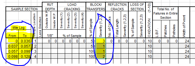
I've never used linear referencing, and I've gone through all of the online tutorials/videos, and I'm still having trouble wrapping my mind around it. I get the concept, but I'm having trouble setting up my tables for the routes, and I don't know how to connect the routes with the base road data. This is a pavement assessment project, where I have 4 segments of a street that have been assigned a rating, based on distant increments (see matrix image). I do not have any route or events set yet, because I don't know how. Everytime I try I'm getting error messages about the length from the road file. I'll be available to communicate any time if anyone online is able to help.
Thank you,
Joshua
Vikhyat Gupta (I was given your name by one of our GIS guys saying you were very helpful)