- Home
- :
- All Communities
- :
- Products
- :
- ArcGIS Online
- :
- ArcGIS Online Questions
- :
- Projection issues with WFS in AGOL
- Subscribe to RSS Feed
- Mark Topic as New
- Mark Topic as Read
- Float this Topic for Current User
- Bookmark
- Subscribe
- Mute
- Printer Friendly Page
- Mark as New
- Bookmark
- Subscribe
- Mute
- Subscribe to RSS Feed
- Permalink
- Report Inappropriate Content
I'm attempting to add a WFS layer to an AGOL map. The data in this layer is (I believe) stored in NZGD2000. However any attempt to display data in an AGOL map results in data significantly offset from its intended location. I've tried every permutation of 'srsName=' I can think of (ie. srsName=EPSG:4326; srsName=EPSG:4167; srsName=urn:x-ogc:def:crs:EPSG:4326; using srsName in the custom parameters; srsName=EPSG:1565 etc. ad nauseam), but this does not appear to make any difference at all. In fact, the features are appearing in exactly the same place every time, which makes me think all these efforts are entirely ineffectual and I might be misunderstanding how this particular parameter operates. This is also one of my first times attempting to make use of a WFS layer, especially in AGOL, so hopefully there's a simple solution that I'm not accounting for.
Solved! Go to Solution.
Accepted Solutions
- Mark as New
- Bookmark
- Subscribe
- Mute
- Subscribe to RSS Feed
- Permalink
- Report Inappropriate Content
Looking at the point layer’s coordinate system in ArcGIS Pro, it is the following:
- Projected: NZGD 2000 New Zealand Transverse Mercator (WKID 2193)
- Geographic: GCS NZGD 2000 (WKID 4167)
The supported Spatial References in the WFS are 4326 and 28354.
Taking ArcGIS Online and re-projecting the data to Web Mercator out of the picture, the service still draws in the incorrect location. The image below is of the WFS service added to an ArcGIS Pro map in its native coordinate system. Reversing the XY coordinates was tested as well and that is not the issue in this case.
The issue is not reproducible in other WFS with 4326 and 28354 as the default spatial reference, even when 3857 (Web Mercator) is not listed as a supported coordinate system. This indicates that the projection issue lies in the discrepancy between the layers and service coordinate systems in the WFS. The plan here is to discuss these issues with the third-party WFS service provider.
- Mark as New
- Bookmark
- Subscribe
- Mute
- Subscribe to RSS Feed
- Permalink
- Report Inappropriate Content
Hi Robin,
From looking at the documentation I believe you are understanding the parameter correctly. Can you try 102100 and 3857 to see if that makes a difference (WKID and Latest WKID of the Web Mercator)?
If the WFS Service is public are you able to post the URL here? I'd be happy to take a quick look on my end.
Thanks,
-Peter
- Mark as New
- Bookmark
- Subscribe
- Mute
- Subscribe to RSS Feed
- Permalink
- Report Inappropriate Content
Hi Peter,
Thanks for the response. Have tried both of these with the same result, unfortunately. Just to confirm, the URL format would be "srsname=wkid:102100"?
Unfortunately there are some privacy restrictions around this particular service, however I'd be happy to share with you privately. Apparently private messaging is restricted however, so if you have any suggestions on the best way to do so, please advise.
Cheers
- Mark as New
- Bookmark
- Subscribe
- Mute
- Subscribe to RSS Feed
- Permalink
- Report Inappropriate Content
Hi Robin,
Thanks for the response on this. Looking at a few more examples of srsName usage, can you try "srsName=EPSG:3857" as the syntax instead?
You can send the service directly to pklingman@esri.com.
Best regards,
-Peter
- Mark as New
- Bookmark
- Subscribe
- Mute
- Subscribe to RSS Feed
- Permalink
- Report Inappropriate Content
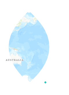
Looking at the point layer’s coordinate system in ArcGIS Pro, it is the following:
- Projected: NZGD 2000 New Zealand Transverse Mercator (WKID 2193)
- Geographic: GCS NZGD 2000 (WKID 4167)
The supported Spatial References in the WFS are 4326 and 28354.
Taking ArcGIS Online and re-projecting the data to Web Mercator out of the picture, the service still draws in the incorrect location. The image below is of the WFS service added to an ArcGIS Pro map in its native coordinate system. Reversing the XY coordinates was tested as well and that is not the issue in this case.
The issue is not reproducible in other WFS with 4326 and 28354 as the default spatial reference, even when 3857 (Web Mercator) is not listed as a supported coordinate system. This indicates that the projection issue lies in the discrepancy between the layers and service coordinate systems in the WFS. The plan here is to discuss these issues with the third-party WFS service provider.