- Home
- :
- All Communities
- :
- Products
- :
- ArcGIS Business Analyst
- :
- ArcGIS Business Analyst Questions
- :
- Drive times of a list of zip codes from a site
- Subscribe to RSS Feed
- Mark Topic as New
- Mark Topic as Read
- Float this Topic for Current User
- Bookmark
- Subscribe
- Mute
- Printer Friendly Page
Drive times of a list of zip codes from a site
- Mark as New
- Bookmark
- Subscribe
- Mute
- Subscribe to RSS Feed
- Permalink
- Report Inappropriate Content
On business analyst online:
Is there a way to know how far away (drive times) zip codes are from a given site? For example if I have 15-30-45 minute drive time rings from a site, is there a way to identify the zip codes within a 15 minute drive time, a 30 minute drive time and a 45 minute drive time from the site?
Thank you in advance for any help.
A
Solved! Go to Solution.
Accepted Solutions
- Mark as New
- Bookmark
- Subscribe
- Mute
- Subscribe to RSS Feed
- Permalink
- Report Inappropriate Content
On the desktop software, there is a handy tool to do this (Create Trade Area From Sub-geography Layer), but since you are using the Business Analyst Online software, you'll need to first share you BAO map with ArcGIS Online using the share button:

Once you share your Business Analyst map with ArcGIS, you can log in to ArcGIS Online and open that map. You'll need to load either the USA ZIP Code Points map layer using the Add Data option (https://services.arcgis.com/P3ePLMYs2RVChkJx/arcgis/rest/services/USA_ZIP_Code_Points_analysis/Featu... ) or the United States ZIP Code Boundaries 2018 (
https://services.arcgis.com/P3ePLMYs2RVChkJx/arcgis/rest/services/USA_Boundaries_2018/FeatureServer )
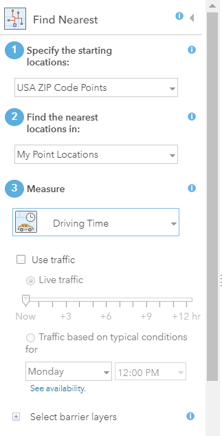
Once you have your ZIP Code map layer loaded, you can use the Analysis tools in ArcGIS Online to overlay the ZIP code layer with your drive time areas and the resulting intersected map layer will have the data that you want.

ArcGIS Online also gives you the option to calculate the drive time from the ZIP code points to your site (or the nearest site) but you'll probably want to do the intersect to get the subset of the points within your drive time areas so that you are not calculating the drive time for ZIP codes outside your drive time area.
Hope this helps.
Regards,
-Susan-
- Mark as New
- Bookmark
- Subscribe
- Mute
- Subscribe to RSS Feed
- Permalink
- Report Inappropriate Content
On the desktop software, there is a handy tool to do this (Create Trade Area From Sub-geography Layer), but since you are using the Business Analyst Online software, you'll need to first share you BAO map with ArcGIS Online using the share button:
Once you share your Business Analyst map with ArcGIS, you can log in to ArcGIS Online and open that map. You'll need to load either the USA ZIP Code Points map layer using the Add Data option (https://services.arcgis.com/P3ePLMYs2RVChkJx/arcgis/rest/services/USA_ZIP_Code_Points_analysis/Featu... ) or the United States ZIP Code Boundaries 2018 (
https://services.arcgis.com/P3ePLMYs2RVChkJx/arcgis/rest/services/USA_Boundaries_2018/FeatureServer )
Once you have your ZIP Code map layer loaded, you can use the Analysis tools in ArcGIS Online to overlay the ZIP code layer with your drive time areas and the resulting intersected map layer will have the data that you want.
ArcGIS Online also gives you the option to calculate the drive time from the ZIP code points to your site (or the nearest site) but you'll probably want to do the intersect to get the subset of the points within your drive time areas so that you are not calculating the drive time for ZIP codes outside your drive time area.
Hope this helps.
Regards,
-Susan-
- Mark as New
- Bookmark
- Subscribe
- Mute
- Subscribe to RSS Feed
- Permalink
- Report Inappropriate Content
Hi Susan, it works like a charm!
The only thing I can't figure out is when I export the data in .csv or .xls, it sometimes outputs multiple rings for a single zip code. I can see that when the zip code is actually in ring #1, it shows it as under all 3 rings (1 row for each ring). When it's actually in ring 2, it shows it under ring #2 and ring #3.
Is there a way for it to output to a single ring?
Also, I assume that any zip code that is not within the rings is not outputted. Is this correct?
Thank you SO much for your help.
A
- Mark as New
- Bookmark
- Subscribe
- Mute
- Subscribe to RSS Feed
- Permalink
- Report Inappropriate Content
Based on your description, I think you forgot to select the "Bands" option when you created your drive time areas:
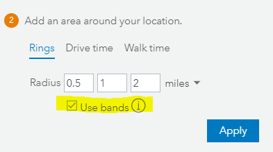
In the screen capture above, the bands option creates areas from 0 - .5, .5 to 1 and 1 - 2. Without the bands option, it creates the areas from 0 - .5, 0 - 1 and 0 - 2 and there will be overlap that will then get carried into the intersect process.
However, there is also a case where you can get multiple zip codes within the same drive time area and multiple zip codes within two drive time areas. The reason why you can get multiple rings for a single zip code is illustrated below:

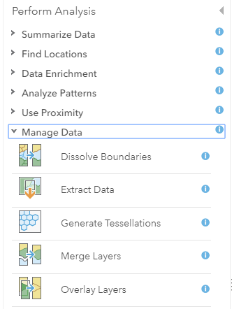
Let's say the green outline is a zip code polygon and the purple line is the border between two drive time areas. Because the intersect overlay is going to "cut" the green polygon by the purple line, you will get multiple pieces of the zip code in the "northern" part of the drive time area and a single zip code polygon associated with the drive time area in the southern part of the image. This is exactly what we would expect the software to do in this case, but we would really want the two "upper" polygon pieces to be merged into a single polygon. While you can do that with a "Dissolve Boundaries" tool in ArcGIS Online, you may want to simply use a pivot table in Excel to combine the zip codes into a unique list for each drive time area.
When you use Intersect (but not Union), only zip codes that are within the drive time area will be returned in the attribute table of the resulting map layer.
Regards,
-Susan-
- Mark as New
- Bookmark
- Subscribe
- Mute
- Subscribe to RSS Feed
- Permalink
- Report Inappropriate Content
This is awesome thank you again for your help.