- Home
- :
- All Communities
- :
- User Groups
- :
- Land Use / Land Cover / Forest Cover Mapping
- :
- Questions
- :
- Zonal statistics for land cover analysis within ve...
- Subscribe to RSS Feed
- Mark Topic as New
- Mark Topic as Read
- Float this Topic for Current User
- Bookmark
- Subscribe
- Mute
- Printer Friendly Page
Zonal statistics for land cover analysis within vector polygons
- Mark as New
- Bookmark
- Subscribe
- Mute
- Subscribe to RSS Feed
- Permalink
- Report Inappropriate Content
What I’m trying to accomplish is simple to define: what is the percentage tree cover (raster) across four polygon zones (vector)? When I run my analysis using Zonal Statistics as a Table, I get an equal ratio of tree canopy in each zone (Count/Area). Each zone seems to have 25% of the total tree canopy count, but this can’t possibly be accurate. Screenshot is below and the ratio of Count (i.e. tree pixels)/Area across all four zones is .25. Common sense tells us that the tree canopy wouldn't be equally distributed across any area like this so obviously I'm doing something wrong. HOLC_Grade is the four polygon zones grades where A='good' neighborhoods' and D= 'bad' neighborhoods according to redlining criteria used to establish discriminatory lending practices in Chicago. My hypothesis is that areas that were redlined in the past might have a lower percentage of tree canopy than areas that were not.
- High-Resolution Land Cover, Cook County 2010 the Chicago Region Trees Initiative https://datahub.cmap.illinois.gov/dataset/high-resolution-land-cover-cook-county-2010
- Home Owners Lending Corporation Redlining shapefile for Chicago from here: https://dsl.richmond.edu/panorama/redlining/#loc=9/41.944/-87.771&maps=0&text=downloads
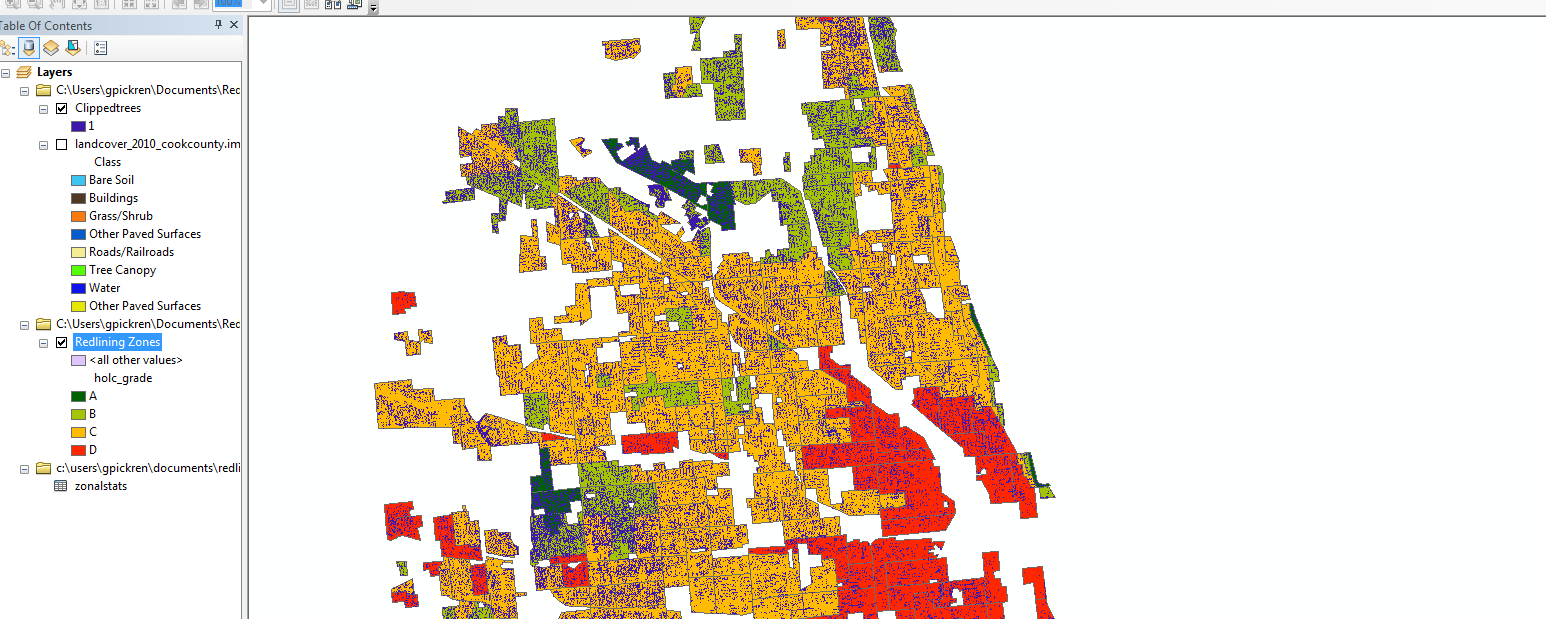
- This layer has four redlining ‘grades’ that indicate how viable a neighborhood was for lending. These grades were symbolized as polygons of different colors where red='bad' areas denied lending.
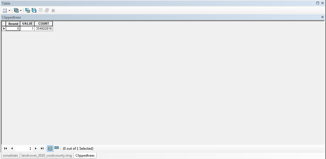
- I get a clipped layer with an attribute table that looks like this (where Value of 1 is = Tree Canopy). So there are 354,919,880 tree canopy pixels in the redlined polygon zones.
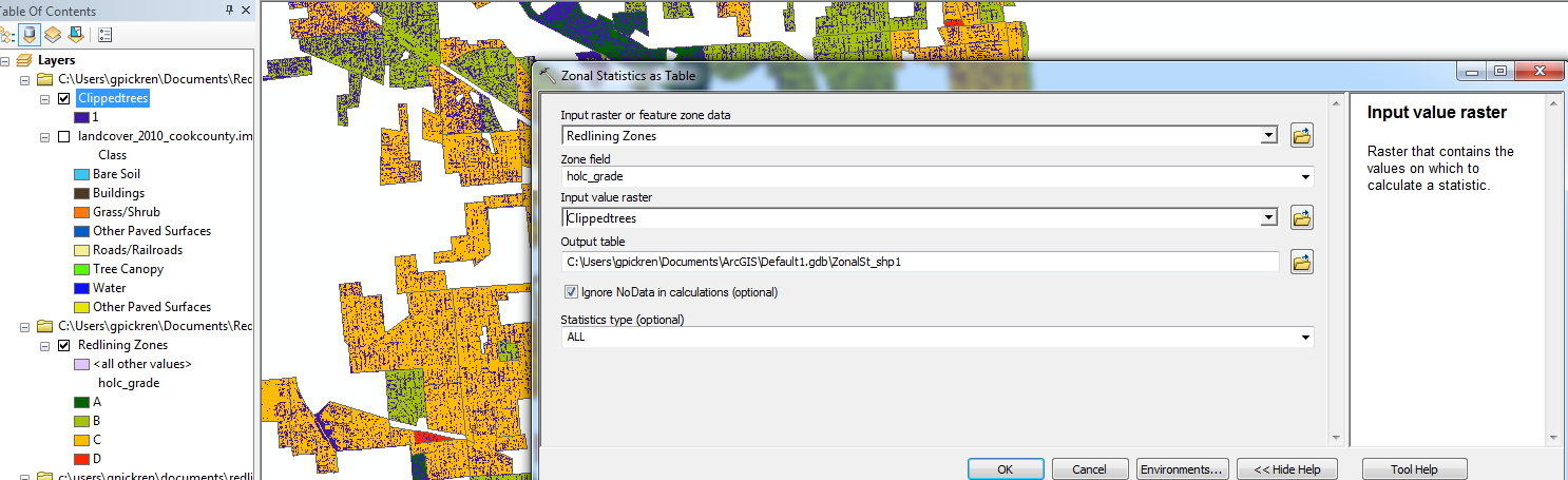
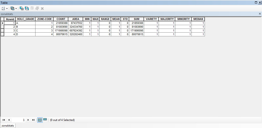
a) Redlining layer as the feature zone datab) ‘holc_grade’ as my Zone Field (these are the four investment zones)c) My new Clipped Tree Canopy raster as the Input Value Rasterd) selecting all statisticsThe resulting zonal statistics table I get looks like this, with the Count/Area ratio by 25% across each polygon zoneI'm wondering ifa) I'm not understanding what Count and Area really mean? Count is the number of pixels, and Area is square meters...b) There is a projection issue? I set the Data Frame to UTM Zone 15N when I started the project. However, when I check the Source Properties for my Redlined layer it says the GCS is WGS 1984, but doesn't list a projection.I'm also including a screenshot of my TOC and map just for reference.Any help is much appreciated!
- Mark as New
- Bookmark
- Subscribe
- Mute
- Subscribe to RSS Feed
- Permalink
- Report Inappropriate Content
Are your 'zones' unique? or do you have several areas with the same value?
How Zonal Statistics works—Help | ArcGIS Desktop
A zone is all the cells in a raster that have the same value, whether or not they are contiguous.
There are situations where you might have to use RegionGroup to isolate areas which are not contiguous but have the same value.
- Mark as New
- Bookmark
- Subscribe
- Mute
- Subscribe to RSS Feed
- Permalink
- Report Inappropriate Content
Hi Dan, thanks for the response. There are four polygon zones (A, B, C, D) in my vector layer. These zones are not always contiguous. What I really want to know is how many tree canopy pixels (value of 1) are in each zone. Unfortunately, grouping them together by contiguity doesn't help me do that unless there are some additional steps you would suggest.
- Mark as New
- Bookmark
- Subscribe
- Mute
- Subscribe to RSS Feed
- Permalink
- Report Inappropriate Content
Hello Graham, I am also trying to accomplish what you proposed in this question. If you are able to provide any additional insight to this issue I would greatly appreciate it!