- Home
- :
- All Communities
- :
- User Groups
- :
- CAD/GIS Data Integration
- :
- Questions
- :
- Editing an attribute table
- Subscribe to RSS Feed
- Mark Topic as New
- Mark Topic as Read
- Float this Topic for Current User
- Bookmark
- Subscribe
- Mute
- Printer Friendly Page
Editing an attribute table
- Mark as New
- Bookmark
- Subscribe
- Mute
- Subscribe to RSS Feed
- Permalink
- Report Inappropriate Content
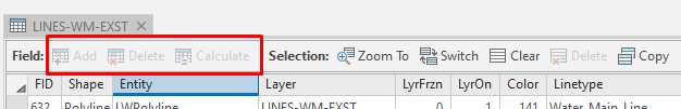
I'm trying to edit an attribute table and from what I can see the table is not editable currently as the Add/Delete/Calculate buttons are greyed out. I've been trying to find a tutorial on this but what I've found starts off with the assumption that a table is editable.
- Mark as New
- Bookmark
- Subscribe
- Mute
- Subscribe to RSS Feed
- Permalink
- Report Inappropriate Content
Peter,
You cannot edit CAD data directly. You have to convert it to a feature class first (shapefile, file geodatabase, etc.).
If you're using ArcMap and already have a feature class, you first need to start an Edit Session. From the Editor toolbar above (if it's not there, go to Customize --> Toolbars --> Editor), click on the drop down menu and select Start Editing.
- Mark as New
- Bookmark
- Subscribe
- Mute
- Subscribe to RSS Feed
- Permalink
- Report Inappropriate Content
I've made the switch to ArcPro. Is there a process for converting cad to shape file geodatabase? Or is it the same as it was in Arcmap?
- Mark as New
- Bookmark
- Subscribe
- Mute
- Subscribe to RSS Feed
- Permalink
- Report Inappropriate Content
Peter Sharkey, yes, it's practically the same thing as ArcMap:
https://pro.arcgis.com/en/pro-app/tool-reference/conversion/cad-to-geodatabase.htm
There is a tool, CAD to Geodatabase. There are many ways to do this; that is just one.
- Mark as New
- Bookmark
- Subscribe
- Mute
- Subscribe to RSS Feed
- Permalink
- Report Inappropriate Content
The Cad to Geodatabase tool doesn't seem to keep the annotation/text from the original CAD drawing. Am I missing a step?
- Mark as New
- Bookmark
- Subscribe
- Mute
- Subscribe to RSS Feed
- Permalink
- Report Inappropriate Content
Peter, there are many reasons why this could be happening. Can you post a screenshot of what you're seeing?
Also, sometimes it's there but just not labeled.
I have found with certain dgn drawings, the text has to be exploded first in order for it to show up in GIS.
- Mark as New
- Bookmark
- Subscribe
- Mute
- Subscribe to RSS Feed
- Permalink
- Report Inappropriate Content
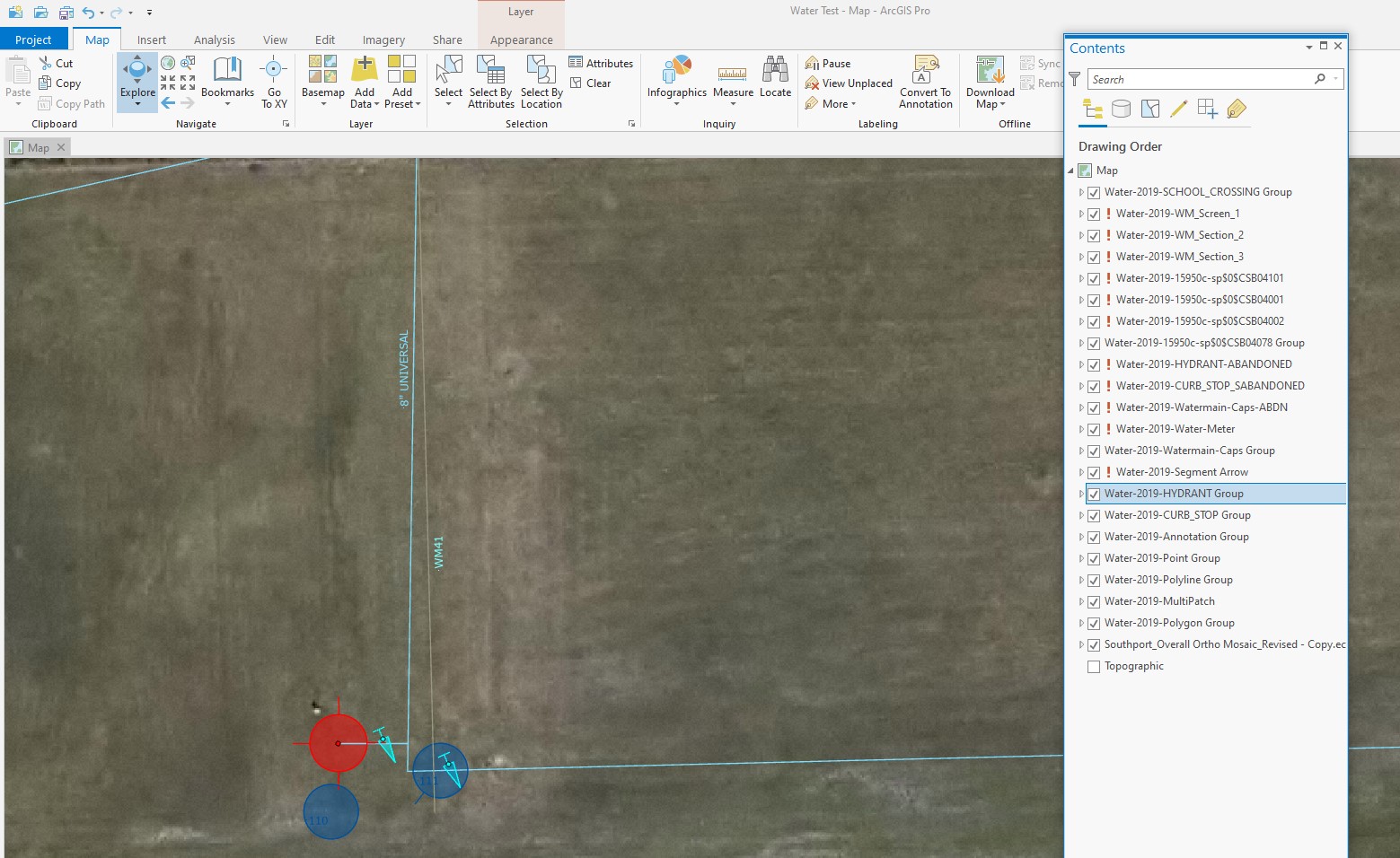
The first screenshot shows my Autocad file imported. The colors of the lines now in ArcGIS are the same as Autocad which is awesome and everything is on separate layers same as Autocad.
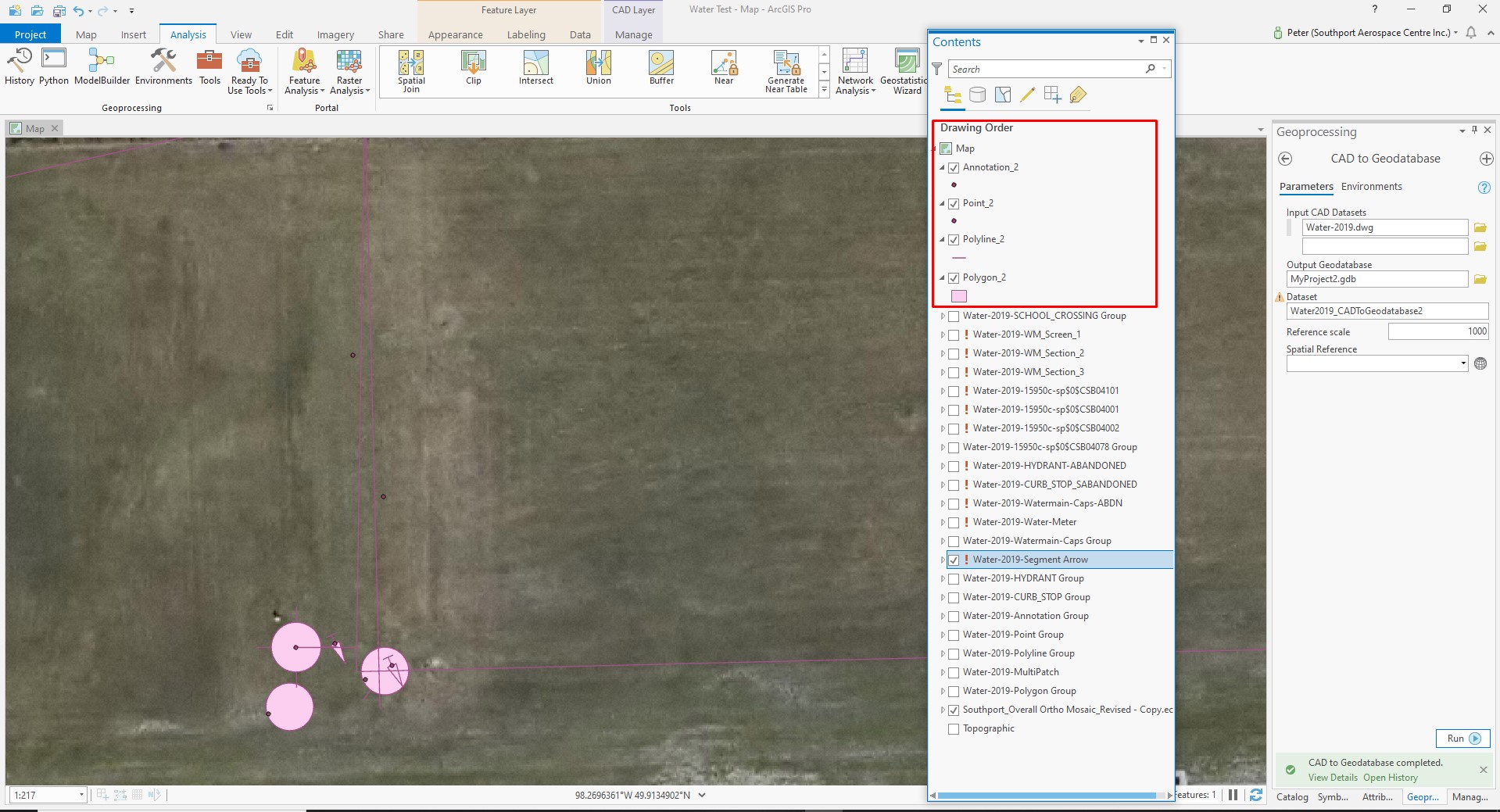
This next image shows what the content looks like after the CAD to Geodatabase runs. I shut off all the Autocad layers and leave the new Geodatabase content on (shown in red). But now all of the annotation is gone, all of the original Autocad colors have switched to something else by default, and all of the geometry has been condensed into only a few layers. Not what I wanted.
- Mark as New
- Bookmark
- Subscribe
- Mute
- Subscribe to RSS Feed
- Permalink
- Report Inappropriate Content
Yeah, looks like standard behavior. CAD and GIS aren't the best of friends.
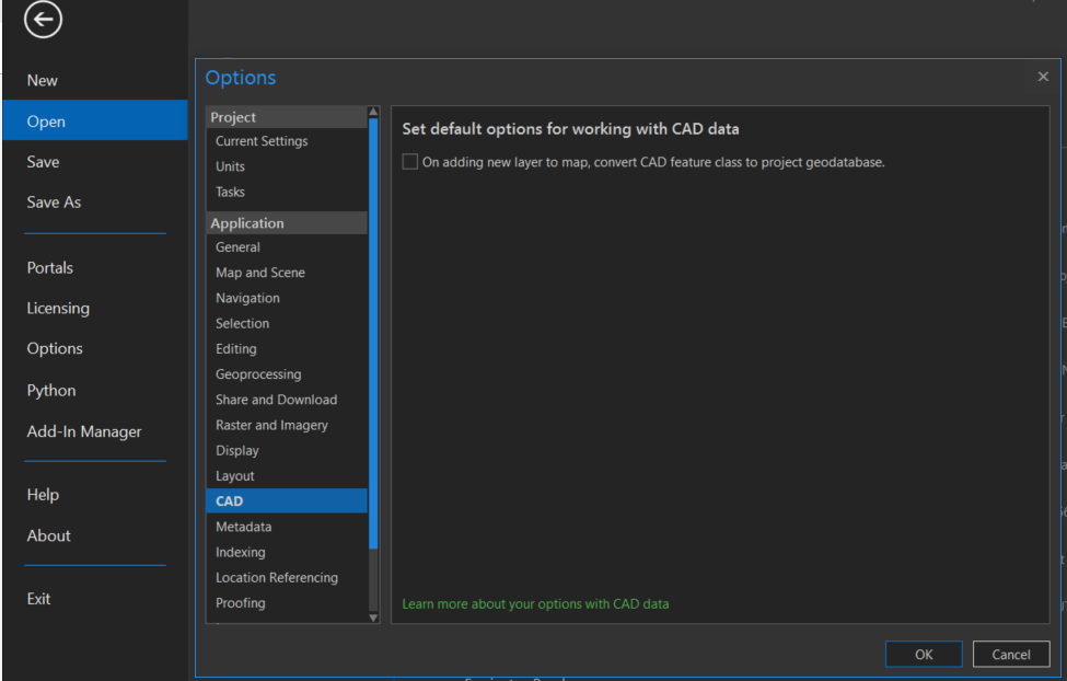
One option that might solve many of your issues is to go to the Project ribbon (upper left), then Options, then CAD, and check on the box:
For your annotation, right click on the layer, and turn on the labels. You may have to mess around with the labels some (in labelling properties) to get what you want.
- Mark as New
- Bookmark
- Subscribe
- Mute
- Subscribe to RSS Feed
- Permalink
- Report Inappropriate Content
Wow, that was actually a pretty easy way to turn the labelling on.
But when it comes to the imported lines from CAD, when creating the CAD to Geodatabase, It still puts all of the lines on the same layer.
In ArcMap, you taught me to right click on the layer, open layer properties, Click Symbology tab, select Categories, select "Unique Value, many fields", and then "add all values" - which would then put the geometry on different layers. I don't see a similar process in Pro. Is there a similar process?
- Mark as New
- Bookmark
- Subscribe
- Mute
- Subscribe to RSS Feed
- Permalink
- Report Inappropriate Content
Peter Sharkey, the process is exactly the same, just the clicks are different:
https://pro.arcgis.com/en/pro-app/help/mapping/layer-properties/unique-value.htm
Either right click on the layer and go to Symbology or left click on the layer and open the Appearance ribbon at the top when it activates contextually, and mess with symbology from there.