- Home
- :
- All Communities
- :
- Developers
- :
- Native Maps SDKs
- :
- Runtime SDK for iOS Questions
- :
- Invalid renderer JSON in Runtime geodatabase
- Subscribe to RSS Feed
- Mark Topic as New
- Mark Topic as Read
- Float this Topic for Current User
- Bookmark
- Subscribe
- Mute
- Printer Friendly Page
- Mark as New
- Bookmark
- Subscribe
- Mute
- Subscribe to RSS Feed
- Permalink
- Report Inappropriate Content
Our ArcGIS Servers (10.6.1) seem to have started producing invalid runtime .geodatabase exports at some point in the last few days.
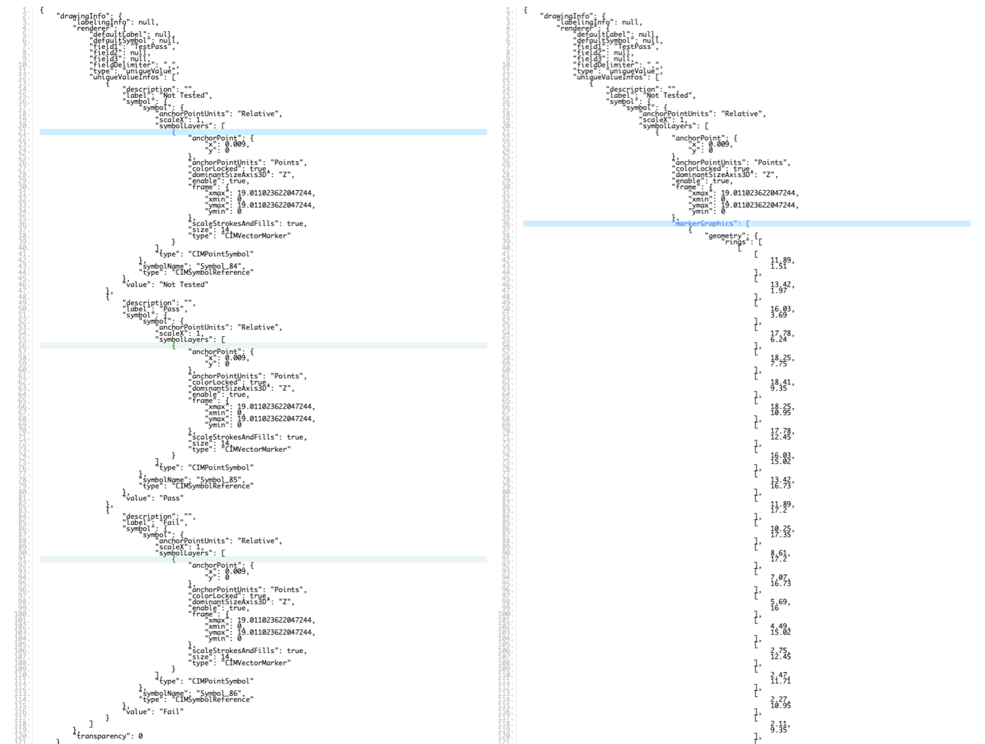
It looks like the runtime databases no longer contain valid JSON for unique value renderers. Whereas the JSON in the runtime gdb would previously looked like this:
{"drawingInfo":{"renderer":{"type":"uniqueValue","field1":"TestPass","field2":null,"field3":null,"defaultSymbol":null,"defaultLabel":null,"uniqueValueInfos":[{"symbol":{"type":"CIMSymbolReference","symbol":{"type":"CIMPointSymbol","symbolLayers":[{"type":"CIMVectorMarker","enable":true,"colorLocked":true,"anchorPoint":{"x":0.00899999999999999932,"y":0},"anchorPointUnits":"Points","scaleStrokesAndFills":true,"size":14,"dominantSizeAxis3D":"Z","frame":{"xmin":0,"ymin":0,"xmax":19.01102362204724372,"ymax":19.01102362204724372},"markerGraphics":[{"type":"CIMMarkerGraphic","geometry":{"rings":[[[11.89,1.51],[13.42,1.97],[16.03,3.69],[17.78,6.24],[18.25,7.75],[18.41,9.35],[18.25,10.95],[17.78,12.45],[16.03,15.02],[13.42,16.73],[11.89,17.2],[10.25,17.35],[8.61,17.2],[7.07,16.73],[5.69,16.0],[4.49,15.02],[2.75,12.45],[2.47,11.71],[2.27,10.95],[2.11,9.35],[2.27,7.75],[2.75,6.24],[4.49,3.69],[5.07,3.17],[5.69,2.71],[7.07,1.97],[8.61,1.51],[10.25,1.35],[11.89,1.51]]],"spatialReference":{"wkid":null}},"symbol":{"type":"CIMPolygonSymbol","symbolLayers":[{"type":"CIMFill","enable":true,"colorLocked":true,"pattern":{"type":"CIMSolidPattern","color":[0,197,255,255]}}]}}]}],"anchorPointUnits":"Relative","scaleX":1},"symbolName":"Symbol_84"},"value":"Not Tested","label":"Not Tested","description":""},{"symbol":{"type":"CIMSymbolReference","symbol":{"type":"CIMPointSymbol","symbolLayers":[{"type":"CIMVectorMarker","enable":true,"colorLocked":true,"anchorPoint":{"x":0.00899999999999999932,"y":0},"anchorPointUnits":"Points","scaleStrokesAndFills":true,"size":14,"dominantSizeAxis3D":"Z","frame":{"xmin":0,"ymin":0,"xmax":19.01102362204724372,"ymax":19.01102362204724372},"markerGraphics":[{"type":"CIMMarkerGraphic","geometry":{"rings":[[[11.89,1.51],[13.42,1.97],[16.03,3.69],[17.78,6.24],[18.25,7.75],[18.41,9.35],[18.25,10.95],[17.78,12.45],[16.03,15.02],[13.42,16.73],[11.89,17.2],[10.25,17.35],[8.61,17.2],[7.07,16.73],[5.69,16.0],[4.49,15.02],[2.75,12.45],[2.47,11.71],[2.27,10.95],[2.11,9.35],[2.27,7.75],[2.75,6.24],[4.49,3.69],[5.07,3.17],[5.69,2.71],[7.07,1.97],[8.61,1.51],[10.25,1.35],[11.89,1.51]]],"spatialReference":{"wkid":null}},"symbol":{"type":"CIMPolygonSymbol","symbolLayers":[{"type":"CIMFill","enable":true,"colorLocked":true,"pattern":{"type":"CIMSolidPattern","color":[85,255,0,255]}}]}}]}],"anchorPointUnits":"Relative","scaleX":1},"symbolName":"Symbol_85"},"value":"Pass","label":"Pass","description":""},{"symbol":{"type":"CIMSymbolReference","symbol":{"type":"CIMPointSymbol","symbolLayers":[{"type":"CIMVectorMarker","enable":true,"colorLocked":true,"anchorPoint":{"x":0.00899999999999999932,"y":0},"anchorPointUnits":"Points","scaleStrokesAndFills":true,"size":14,"dominantSizeAxis3D":"Z","frame":{"xmin":0,"ymin":0,"xmax":19.01102362204724372,"ymax":19.01102362204724372},"markerGraphics":[{"type":"CIMMarkerGraphic","geometry":{"rings":[[[11.89,1.51],[13.42,1.97],[16.03,3.69],[17.78,6.24],[18.25,7.75],[18.41,9.35],[18.25,10.95],[17.78,12.45],[16.03,15.02],[13.42,16.73],[11.89,17.2],[10.25,17.35],[8.61,17.2],[7.07,16.73],[5.69,16.0],[4.49,15.02],[2.75,12.45],[2.47,11.71],[2.27,10.95],[2.11,9.35],[2.27,7.75],[2.75,6.24],[4.49,3.69],[5.07,3.17],[5.69,2.71],[7.07,1.97],[8.61,1.51],[10.25,1.35],[11.89,1.51]]],"spatialReference":{"wkid":null}},"symbol":{"type":"CIMPolygonSymbol","symbolLayers":[{"type":"CIMFill","enable":true,"colorLocked":true,"pattern":{"type":"CIMSolidPattern","color":[255,0,0,255]}}]}}]}],"anchorPointUnits":"Relative","scaleX":1},"symbolName":"Symbol_86"},"value":"Fail","label":"Fail","description":""}],"fieldDelimiter":","},"transparency":0,"labelingInfo":null}}
It now looks like this:
{"drawingInfo":{"renderer":{"type":"uniqueValue","field1":"TestPass","field2":null,"field3":null,"defaultSymbol":null,"defaultLabel":null,"uniqueValueInfos":[{"symbol":{"type":"CIMSymbolReference","symbol":{"type":"CIMPointSymbol","symbolLayers":[{"type":"CIMVectorMarker","enable":true,"colorLocked":true,"anchorPoint":{"x":0.00899999999999999932,"y":0},"anchorPointUnits":"Points","scaleStrokesAndFills":true,"size":14,"dominantSizeAxis3D":"Z","frame":{"xmin":0,"ymin":0,"xmax":19.01102362204724372,"ymax":19.01102362204724372}}],"anchorPointUnits":"Relative","scaleX":1},"symbolName":"Symbol_84"},"value":"Not Tested","label":"Not Tested","description":""},{"symbol":{"type":"CIMSymbolReference","symbol":{"type":"CIMPointSymbol","symbolLayers":[{"type":"CIMVectorMarker","enable":true,"colorLocked":true,"anchorPoint":{"x":0.00899999999999999932,"y":0},"anchorPointUnits":"Points","scaleStrokesAndFills":true,"size":14,"dominantSizeAxis3D":"Z","frame":{"xmin":0,"ymin":0,"xmax":19.01102362204724372,"ymax":19.01102362204724372}}],"anchorPointUnits":"Relative","scaleX":1},"symbolName":"Symbol_85"},"value":"Pass","label":"Pass","description":""},{"symbol":{"type":"CIMSymbolReference","symbol":{"type":"CIMPointSymbol","symbolLayers":[{"type":"CIMVectorMarker","enable":true,"colorLocked":true,"anchorPoint":{"x":0.00899999999999999932,"y":0},"anchorPointUnits":"Points","scaleStrokesAndFills":true,"size":14,"dominantSizeAxis3D":"Z","frame":{"xmin":0,"ymin":0,"xmax":19.01102362204724372,"ymax":19.01102362204724372}}],"anchorPointUnits":"Relative","scaleX":1},"symbolName":"Symbol_86"},"value":"Fail","label":"Fail","description":""}],"fieldDelimiter":","},"transparency":0,"labelingInfo":null}}
Aside from being considerably shorter this JSON is missing the marker symbols from the unique value renderer object. Here's a screenshot of a JSON diff:
This is happening on multiple servers. PLEASE HELP!!
Happy 4th everyone 🙂
Solved! Go to Solution.
Accepted Solutions
- Mark as New
- Bookmark
- Subscribe
- Mute
- Subscribe to RSS Feed
- Permalink
- Report Inappropriate Content
Hi Michael,
Thanks for providing the JSON. Very helpful. I think you're hitting a bug introduced with the latest Windows update that affects Server and Desktop tools.
See Feature layer not displaying in Explorer app, but displays in AGO and in particular Jeremy Wright's reply here. We are actively working with Microsoft on a fix and assessing all options to provide a fix as soon as possible. It seems some customers have been able to resolve the issue by rolling back the Windows patch but this is of course at best a poor compromise.
Please monitor that thread for updates. We're confident we understand the issue but if you have configurations that aren't covered by the thread's explanation, do add your details there.
Cheers,
Nick.
- Mark as New
- Bookmark
- Subscribe
- Mute
- Subscribe to RSS Feed
- Permalink
- Report Inappropriate Content
Thanks Nick - I have a ticket in through our organization account and we are looking at the possibility of rolling back recent Windows updates. In the mean-time I'm pushing out app updates with hard coded unique value renderers. This seems to be working and will keep our runtime apps functioning... not sure what we will do about any Collector/Explorer users who might be consuming registered feature service published from ArcMap, but I suppose that is a topic for a different forum.
Thanks again.
- Mark as New
- Bookmark
- Subscribe
- Mute
- Subscribe to RSS Feed
- Permalink
- Report Inappropriate Content
Sure thing Michael.
Depending on what you need them for, you could also set the useAdvancedSymbology property to false on your feature table until this is resolved. See this conversation where Lucas offers some more details.
That still doesn't help with Explorer/Collector users though, unfortunately.
- Mark as New
- Bookmark
- Subscribe
- Mute
- Subscribe to RSS Feed
- Permalink
- Report Inappropriate Content
I just saw that - honestly had no idea that option existed... might save a ton of time!