- Home
- :
- All Communities
- :
- Products
- :
- ArcGIS Survey123
- :
- ArcGIS Survey123 Questions
- :
- Adding decimals to Lat/Long on preview map.
- Subscribe to RSS Feed
- Mark Topic as New
- Mark Topic as Read
- Float this Topic for Current User
- Bookmark
- Subscribe
- Mute
- Printer Friendly Page
Adding decimals to Lat/Long on preview map.
- Mark as New
- Bookmark
- Subscribe
- Mute
- Subscribe to RSS Feed
- Permalink
- Report Inappropriate Content
Hi everyone,
I may just be missing it, but is there a way to control the number of decimals shown on the preview map of survey123? Basically I dont want my users opening the detailed map because I have added a calculation to record manually entered latitudes and longitudes to the geopoint, and opening up the detailed map and moving it around messes with the geopoint recorded.
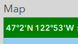
My users are out on boats, and want to be able to physically navigate go back to locations already recorded by reading the lat long in the US Coast Guard standard decimal minutes. I could calculate these values and display them, but the preview map already shows them in degrees minutes and so adding decimal minutes to that would be an easier fix.
Allowing survey owners to change the format of the preview map's displayed coordinate system would be a nice little addition to survey123 connect if not already available.
Thanks for your help!
- Mark as New
- Bookmark
- Subscribe
- Mute
- Subscribe to RSS Feed
- Permalink
- Report Inappropriate Content
Hi Andrew,
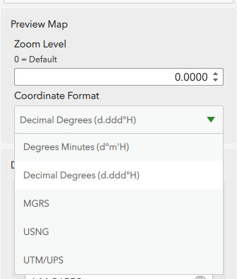
This can be done in Survey123 Connect - go to 'Settings' > 'Map' and set the coordinate display for the preview map:
- Mark as New
- Bookmark
- Subscribe
- Mute
- Subscribe to RSS Feed
- Permalink
- Report Inappropriate Content
Is there a way to get the decimal minutes to show? That's the real problem is I need at least 2 decimal places for navigating.