- Home
- :
- All Communities
- :
- Products
- :
- Mapping
- :
- Map Projections Questions
- :
- Map Topology Cluster Tolerance
- Subscribe to RSS Feed
- Mark Topic as New
- Mark Topic as Read
- Float this Topic for Current User
- Bookmark
- Subscribe
- Mute
- Printer Friendly Page
Map Topology Cluster Tolerance
- Mark as New
- Bookmark
- Subscribe
- Mute
- Subscribe to RSS Feed
- Permalink
- Report Inappropriate Content
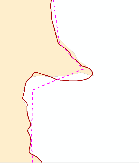
I have data that I would like to line up perfectly. In the past, I have used the align edge tool in the topology tools as a fairly quick and easy way to do this. The dataset I'm working with covers a large area (1:2m scale), so I have all the data projected into WGS 84. In the image I've included, you can see the pink topology edge line doesn't match either dataset. I have made sure the 2 layers shown are the only ones in the map topology. When I try to adjust the cluster tolerance in the advanced settings, everything I enter returns, " the specified cluster tolerance is less than the minimum allowed by the spatial reference ..." Any suggestions on how to get the data to look decent at it's full scale and allow me to match the shapes. The only idea I have is to project my data into a local (state plane) coordinate system, and then re-project it into WGS once I've matched it. But my intuition says there is a better way to do this, and I just can't think of it. Does anyone have any ideas?
Thank you!