- Home
- :
- All Communities
- :
- Events
- :
- ArcGIS User Seminar and Workshop
- :
- ArcGIS User Seminar and Workshop Questions
- :
- Import MS excel file into a gdb
- Subscribe to RSS Feed
- Mark Topic as New
- Mark Topic as Read
- Float this Topic for Current User
- Bookmark
- Subscribe
- Mute
- Printer Friendly Page
- Mark as New
- Bookmark
- Subscribe
- Mute
- Subscribe to RSS Feed
- Permalink
- Report Inappropriate Content
Hi, GeoNet people!
I'm having an issue with building a gdb on ArcGIS v.10. I attached an error message when I tried to import an excel file that contains only three columns with letters and numbers (decimal). I've looked it up how to resolve the problem and eventually delete MS office including AccessDatabase and suit to be paired with ArcGIS. However, I'm still getting the same error message.
Did any recent ArcGIS user had the same trouble as I did, if so how should I resolve this?
thanks
Solved! Go to Solution.
Accepted Solutions
- Mark as New
- Bookmark
- Subscribe
- Mute
- Subscribe to RSS Feed
- Permalink
- Report Inappropriate Content
Hello,
Ensure there is no spaces in the Header row of excel sheet. In MS Excel, you could use Save As option to save it in 97/2003 format (*.xls). Add the Excel Table to ArcMap. Right-Click the Excel table in Table of Contents (ArcMap), and export it to geodatabase table.
If the issue still persist, you could attached the Excel sheet so that we can check it.
Think Location
- Mark as New
- Bookmark
- Subscribe
- Mute
- Subscribe to RSS Feed
- Permalink
- Report Inappropriate Content
Excel To Table—Conversion toolbox | ArcGIS Desktop for arcmap and Pro, but you need to adhere to some basic rules
Work with Microsoft Excel files in ArcGIS Pro—Excel | ArcGIS Desktop
Some include
mixed types in columns (don't mix numbers and text in a column) and blank cells are a definite problem area,
If you have to assign nodata values, pick one but don't leave the cells blank.
- Mark as New
- Bookmark
- Subscribe
- Mute
- Subscribe to RSS Feed
- Permalink
- Report Inappropriate Content
Hi, Dan.
Thanks for the response. The guide was saying that arcgis support 2003 or earlier MS office and 2007. Apparently I'm using MS office 2016, which I concern if that causes to give this error message on arc catalog.
" 
- Mark as New
- Bookmark
- Subscribe
- Mute
- Subscribe to RSS Feed
- Permalink
- Report Inappropriate Content
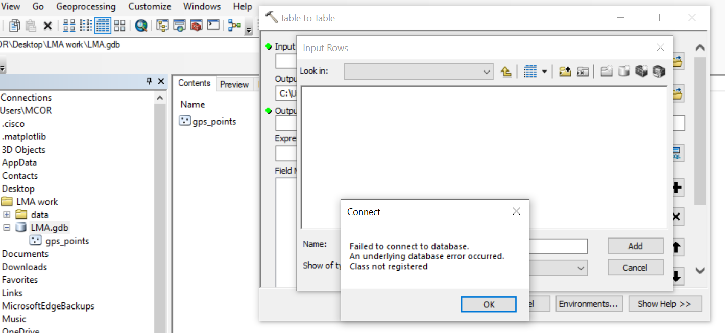
You indicate an Excel file in your first post, hence my recommendations on how to bring an excel file in and make it a gdb table. Not sure what your table to table tool image is about at all
- Mark as New
- Bookmark
- Subscribe
- Mute
- Subscribe to RSS Feed
- Permalink
- Report Inappropriate Content
I referenced ESRI page to run python. But I got an error message: 
I changed any of files being used that has underscore"_", and still getting the same error message. I can't seem to think what went wrong and how to resolve this issue(importing excel file with lat long into arcmap)
- Mark as New
- Bookmark
- Subscribe
- Mute
- Subscribe to RSS Feed
- Permalink
- Report Inappropriate Content
Try raw encoding your path, in Pro, it completely fails. ArcGIS Pro brings a whole new slate of issues since Python 3.x is used
# ---- Your future if you continue to use space in file paths and filenames
"C:\Users\Long_Path\With spaces\Lat long.xls"
File "<ipython-input-3-5146bebb7550>", line 1
"C:\Users\Long_Path\With spaces\Lat long.xls"
^
SyntaxError: (unicode error) 'unicodeescape' codec can't decode bytes in position 2-3: truncated \UXXXXXXXX escape
# ---- raw encoding
r"C:\Users\Long_Path\With spaces\Lat long.xls" # notice the preceding 'r'
'C:\\Users\\Long_Path\\With spaces\\Lat long.xls'- Mark as New
- Bookmark
- Subscribe
- Mute
- Subscribe to RSS Feed
- Permalink
- Report Inappropriate Content
This the error about not being able to connect to database is is related to this. Though I have never used Office 64 bit so that may add a whole set of problems as ArcMap is a 32 bit app. You probably need to install a 32 bit driver (linked from the help below) to get .xlsx files to read into ArcMap.
- Mark as New
- Bookmark
- Subscribe
- Mute
- Subscribe to RSS Feed
- Permalink
- Report Inappropriate Content
Hello,
Ensure there is no spaces in the Header row of excel sheet. In MS Excel, you could use Save As option to save it in 97/2003 format (*.xls). Add the Excel Table to ArcMap. Right-Click the Excel table in Table of Contents (ArcMap), and export it to geodatabase table.
If the issue still persist, you could attached the Excel sheet so that we can check it.
Think Location
- Mark as New
- Bookmark
- Subscribe
- Mute
- Subscribe to RSS Feed
- Permalink
- Report Inappropriate Content
- Mark as New
- Bookmark
- Subscribe
- Mute
- Subscribe to RSS Feed
- Permalink
- Report Inappropriate Content
- I put the file in c:\temp
- I removed the space in the filename so it was LatLong.xls
- I use Excel to table.... it made a table
- I use XY Table To Point... it made a featureclass... I specified a GCS WGS84 coordinate system since your data are in decimal degrees.
- It looked weird because record 30 has an error ... lat 4.40966639 perhaps 41.40966639 or some other number in your range
- I didn't bother to go back and fix it... you will have to fix the error, rename the table, save it in a spaceless folder and rerun the steps