- Home
- :
- All Communities
- :
- Products
- :
- ArcGIS Pro
- :
- ArcGIS Pro Questions
- :
- Map properties, coordinate systems window is empty
- Subscribe to RSS Feed
- Mark Topic as New
- Mark Topic as Read
- Float this Topic for Current User
- Bookmark
- Subscribe
- Mute
- Printer Friendly Page
Map properties, coordinate systems window is empty
- Mark as New
- Bookmark
- Subscribe
- Mute
- Subscribe to RSS Feed
- Permalink
- Report Inappropriate Content
When I load as first file a vector layer (shapefile or feature class) in 3003 or 3004 Coordinate system (Monte Mario Italy 1 and 2) the Coordinate systems window in Map Properties becomes empty (before loading the file I could check the map coordinate system).
ArcGIS Pro 2.3.2 (service pack 2 installed)
- Mark as New
- Bookmark
- Subscribe
- Mute
- Subscribe to RSS Feed
- Permalink
- Report Inappropriate Content
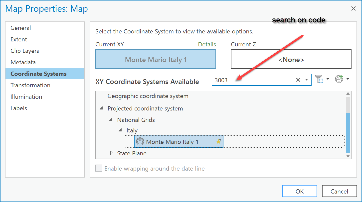
strange... blank project, insert map, right-click properties, coordinate system (defaults to web something ), then I did a search for 3003. Note using downloaded coordinate file if that makes a difference
Same ArcGIS Pro version
- Mark as New
- Bookmark
- Subscribe
- Mute
- Subscribe to RSS Feed
- Permalink
- Report Inappropriate Content
Sorry Dan, I did not understood the meaning of your answer.
Anyway, with the blank project the default coordinate system is Web mercator Auxiliary Sphere (3857).
After having loaded the 3003 file the window empties and you cannot interact with it any more (you cannot input values in the search window, or click any button inside the window).
- Mark as New
- Bookmark
- Subscribe
- Mute
- Subscribe to RSS Feed
- Permalink
- Report Inappropriate Content
Roberto, I don't have a file with that coordinate system so I couldn't test your final steps, I just wanted to make sure that the prior steps of searching/finding the coordinate system worked at least and to clarify if you were using the downloaded version of the coordinate systems.
So step 2, .... do all files with that coordinate system produce the same problem?
I guess you will have to get other people with similar data to test to remove the 'your machine vs always' question
- Mark as New
- Bookmark
- Subscribe
- Mute
- Subscribe to RSS Feed
- Permalink
- Report Inappropriate Content
Sorry but I still don't understand the meaning of the first part of your answer:
- why should I search/find coordinate systems?
- What do you mean with "downloaded version of the coordinate systems"? I use files which were defined (define projection) using ArcGIS pro tool.
Step 2:
- Yes, all the file with that coordinate system produce the problem, I have the blank window only when they are the first files loaded in a new Map.
- I had the same problem in a different computer (with a different OS), I couldn't enrol other "testers".
- Mark as New
- Bookmark
- Subscribe
- Mute
- Subscribe to RSS Feed
- Permalink
- Report Inappropriate Content
I can't replicate, so the situation might be unique to that coordinate system or your environment.
If you calculate the x,y coordinates in the table that would serve as a check as what the coordinate geometry values are. They should have reasonable for your projected coordinate system. If they return geographic coordinates, then the define projection was used when it shouldn't have been
- Mark as New
- Bookmark
- Subscribe
- Mute
- Subscribe to RSS Feed
- Permalink
- Report Inappropriate Content
Sorry Dan, I still have problems understanding your answers... thanks for the efforts.
Why should I calculate coordinates (in the table!?) ? I don't need to check the coordinates, everything it's OK with coordinate values and projection in Map Coordinate system. Why my coordinate should "return geographic coordinates"?
It's just a problem in viewing values in Map properties window...
Thank you again for the efforts, and sorry for the frankness, but I think you should reply if you had something significant to suggest...