- Home
- :
- All Communities
- :
- User Groups
- :
- CAD/GIS Data Integration
- :
- Questions
- :
- Anyone else having Annotation Conversion Problems ...
- Subscribe to RSS Feed
- Mark Topic as New
- Mark Topic as Read
- Float this Topic for Current User
- Bookmark
- Subscribe
- Mute
- Printer Friendly Page
Anyone else having Annotation Conversion Problems using ArcGIS Desktop 10.5.1 (and others) Cad to Geodatabase Tool?
- Mark as New
- Bookmark
- Subscribe
- Mute
- Subscribe to RSS Feed
- Permalink
- Report Inappropriate Content
The CAD to Geodatabase tool apparently lacks programming to assure consistent repeatable conversions of the DGN Levels and Font Size. During the conversion the subtype coded values are not consistently assigned the same Subtype coded values. This deficiency renders the tool useless in providing reliable and repeatable conversions for updating Geodatabases with CAD source. The inconsistent subsequent conversions cause expected data to not be displayed in the expected ArcMap Layer and/or unexpected data to be displayed in random layers.
CAD is our authoritative and continuously updated background data used in our GIS. We must be able to routinely, reliably, and consistently convert CAD to Geodatabase while honoring Annotation Subtype Coded Values in respect of DGN Levels and font sizing for proper display in GIS Maps and Applications. The current tool is not providing consistent results and has caused countless hours of rework and troubleshooting of problems resulting from this deficiency.
Subsequent data manipulation attempts on similar annotation data sets results in scrambled levels/layers.
This seems so elementary in the requirements for CAD to Geodatabase conversions but there does not seem to be a good tool that can handle this basic functionality.
I'm also open to other suggestions for utilizing CAD DGNs in maps and services.
Reference ESRI #BUG-000113627 (Escalated)
- Mark as New
- Bookmark
- Subscribe
- Mute
- Subscribe to RSS Feed
- Permalink
- Report Inappropriate Content
David,
I cannot find any info on Esri's support site about that bug. Do you have a link for it?
In any case, I know people use FME for converting DGN files to GIS and apparently it works wonderfully. FME has some sort of magic that handles that higher level of details that DGN files have and auto-magically converts that data into a useable GIS.
Since my company doesn't have FME, we recently have been using "Tags" in microstation to help signify things better in GIS. This has worked great and after I get the right tags, I just link up a spreadsheet by joining. It ends up looking like this on my attribute table in Pro:
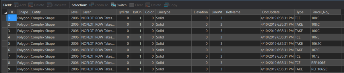
You can see the normal CAD fields but at the end, my CAD guy added some additional info with tags for "Type" and "Parcel_No". This table is the raw CAD data.
I don't do that tagging so I am not fully sure what is involved. My CAD guy told me it's super fast and easy though. Here are a couple of links I found on it:
I hope this helps.
- Mark as New
- Bookmark
- Subscribe
- Mute
- Subscribe to RSS Feed
- Permalink
- Report Inappropriate Content
Adrian,
We have a huge base of CAD Microstation drawings that we use in GIS after converting with the esri CADtoGeodatabase tool. Modifying each drawing format to add Tags would be a lot of work.
Annotation is the only problem we seem to be having and it is related to the unpredictability of the Coded value assignments under subtypes for the Annotation. The coded value assignment really needs to honor the level structure of the original CAD drawing to make the data usable for merges, appends, etc without corrupting the data.
For example: One CAD Drawing for a system may have three levels used as DGN#1 has Level11, Level1, and Level3. A second drawing with very similar info DGN#2 uses only Level11, and Level3 (Omitting Level1).
After using CADtoGeodatabase to convert the two DGNs to GDB:
(GDB)DGN#1 Annotation Assigns Coded values 0,1, and 2 for Level11, Level1, and Level3 respectively.
(GDB)DGN#2 Annotation Assigns Coded values 0 and 1 for Level11, and Level3 respectively.
The Problem: Subsequent merges are based on Subtype Coded Values.
Problem Description: Merging converted data from (GDB)DGN#2 into (GDB)DGN#1 results in (GDB)DGN#1 Level1 having (GDB)DGN#2's Level3 data being merged into (GDB)DGN#1's Level1 (All Coded Value1). This data scrambling causes improperly displayed data in the original (GDB)DGN#1 Map Annotation Layers.
Problem Summary: Level3 Data has been merged into Level1 because they are merged based on coded values.
I also suspect that this problem can occur with CADtoGeodatabase conversions of the same file with only a different version or date stamp. I have not been able to confirm this but I have seen some strange behavior like this that makes me believe the subtype coded value assignments are totally (or nearly) random from conversion to conversion.
Not sure if this link will work for you or not but here is my link to the bug. https://my.esri.com/#/support/bugs/BUG-000113627
- Mark as New
- Bookmark
- Subscribe
- Mute
- Subscribe to RSS Feed
- Permalink
- Report Inappropriate Content
David, I guess that bug is a "private" one. I get a page that says this:
"Unfortunately, you do not have access to the page or process that was requested."
Though, it sounds promising that the bug, whatever it states, is escalated so hopefully it can be resolved soon-ish.
- Mark as New
- Bookmark
- Subscribe
- Mute
- Subscribe to RSS Feed
- Permalink
- Report Inappropriate Content
Thanks
David