- Home
- :
- All Communities
- :
- Products
- :
- Spatial Data Science
- :
- Spatial Data Science Questions
- :
- Raster cell count changes
- Subscribe to RSS Feed
- Mark Topic as New
- Mark Topic as Read
- Float this Topic for Current User
- Bookmark
- Subscribe
- Mute
- Printer Friendly Page
Raster cell count changes
- Mark as New
- Bookmark
- Subscribe
- Mute
- Subscribe to RSS Feed
- Permalink
- Report Inappropriate Content
Hello there!
Disclaimer: I'm a GIS beginner, so this might be a stupid question, but I haven't found useful help yet on the internet.
Every time I do any calculation on my raster (raster calc, reclassify), the cell counts of the different values as well as the total cell count decrease by a factor (almost exactly) 4. The cell sizes and extent of the maps are the same.
This happens even when simply inputting the raster map into the raster calculator (so just duplicating it).
Does anyone have an explanation for this? I appreciate it, thank you!
- Mark as New
- Bookmark
- Subscribe
- Mute
- Subscribe to RSS Feed
- Permalink
- Report Inappropriate Content
can you provide an example where the cell sizes and and extent for inputs and outputs are the same. That factor is just too convenient to be a coincidence for all raster tools in arctoolbox
Also software and version and extensions if any would help narrow down those issues
- Mark as New
- Bookmark
- Subscribe
- Mute
- Subscribe to RSS Feed
- Permalink
- Report Inappropriate Content
Hi Dan, thanks for the fast reply!
Software = ArcMap Desktop 10.6, version 10.6.0.8321, and I'm using the spatial analyst extension.
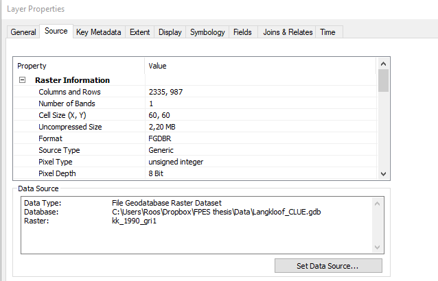
An example would be the raster 'KK_1990_grid_cellsize60', which layer info looks like:

and top op the attribute table:

When I insert this map into raster calculator, it makes the map "kk_1990_gri1", with layer info
And raster attribute table
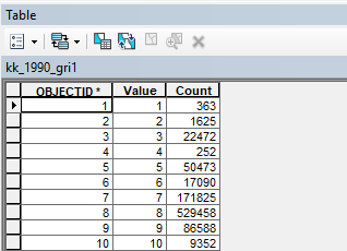
where you can see that all count values are 4 times smaller.
Let me know if you'd need more info to understand! Thanks!
- Mark as New
- Bookmark
- Subscribe
- Mute
- Subscribe to RSS Feed
- Permalink
- Report Inappropriate Content
On the first image … 'Extent' tab... that is what I wanted you to check.
You have confirmed that the rows and columns of the inputs are the same. So the Extent and Spatial reference would be useful.
I also notice Dropbox. can you save your rasters to a local folder in *.tif format... just trying to rule out location and file format as well
- Mark as New
- Bookmark
- Subscribe
- Mute
- Subscribe to RSS Feed
- Permalink
- Report Inappropriate Content
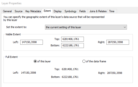
Extent of original map:
Extent of calculated map:
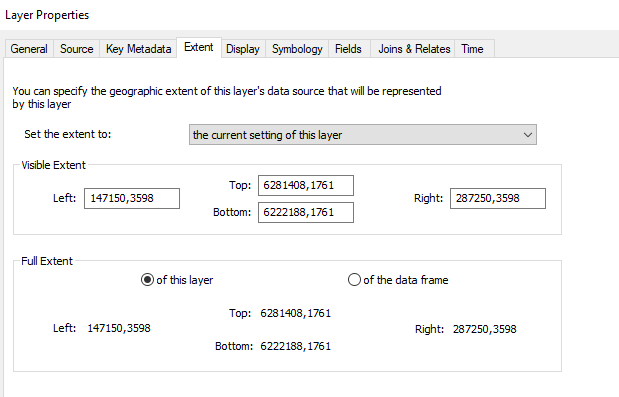
So it's the same..
When I export the file to a local folder and open it in ArcMap, it AGAIN has counts /4. So really when I do anything to the file it divides all cells counts by 4. I'm so confused now.
PS. It happens with other files as well, so it's not specific to this one.
PPS. I also tried the 'build raster attirubute table' tool to check if that fixes it: no.
Thanks again!!
- Mark as New
- Bookmark
- Subscribe
- Mute
- Subscribe to RSS Feed
- Permalink
- Report Inappropriate Content
So if you converted using Value to Value then I haven't seen this before at all. We are either missing the obvious or there is some other issue since you have ruled out coordinate system, extent and raster cell size.... time for tech support
- Mark as New
- Bookmark
- Subscribe
- Mute
- Subscribe to RSS Feed
- Permalink
- Report Inappropriate Content
Alright, thanks anyway for thinking along!
- Mark as New
- Bookmark
- Subscribe
- Mute
- Subscribe to RSS Feed
- Permalink
- Report Inappropriate Content
only one other close... hmmm
- Mark as New
- Bookmark
- Subscribe
- Mute
- Subscribe to RSS Feed
- Permalink
- Report Inappropriate Content
That is actually true for me too:
- my columns & rows are 2335 x 987 = 2,304,645
for both the original and the calculated maps,
- but my total cell countse (as found in classify in symbology) are
- 3,879,242 for the original map and
- 969,802 for the calculated map.
So for both that doesn't make any sense, right?
- Mark as New
- Bookmark
- Subscribe
- Mute
- Subscribe to RSS Feed
- Permalink
- Report Inappropriate Content
skip symbology as being the go to the summary of info. That is a separate issue... I just want to make sure that there is no difference in the actual raster cell count for a 1 to 1 conversion. That is symbology thing, which may have a source of error elsewhere, which I wasn't even looking for. I have found count errors for example in charts which haven't been resolved as yet since they are down on the 'issue' chain I suppose