Turn on suggestions
Auto-suggest helps you quickly narrow down your search results by suggesting possible matches as you type.
Cancel
- Home
- :
- All Communities
- :
- Products
- :
- ArcGIS Pro
- :
- ArcGIS Pro Questions
- :
- Geotagged Photos To Point
Options
- Subscribe to RSS Feed
- Mark Topic as New
- Mark Topic as Read
- Float this Topic for Current User
- Bookmark
- Subscribe
- Mute
- Printer Friendly Page
Geotagged Photos To Point
Subscribe
644
4
03-13-2019 08:10 AM
03-13-2019
08:10 AM
- Mark as New
- Bookmark
- Subscribe
- Mute
- Subscribe to RSS Feed
- Permalink
- Report Inappropriate Content
ArcGIS Pro 2.3.1
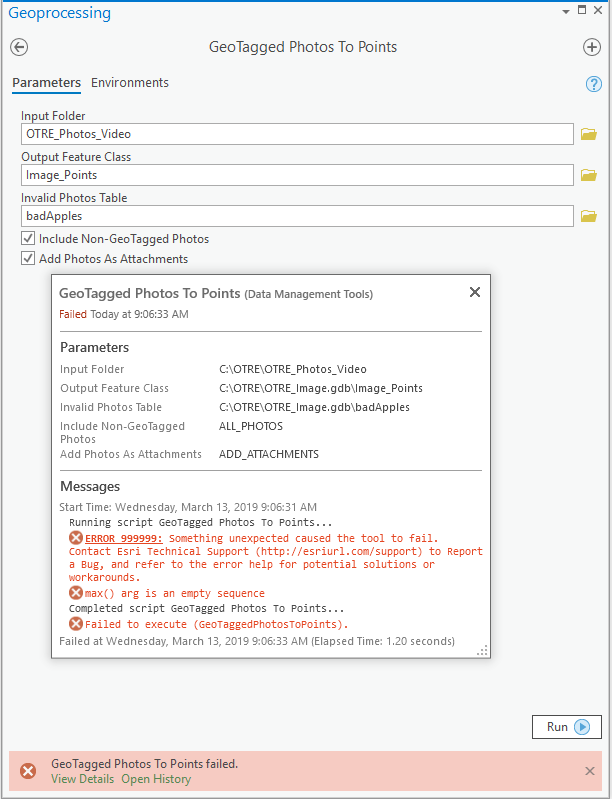
First time ever using this tool and it bails out with the infamous Error 999999 Something unexpected.....
But the max() arg is an empty sequence is interesting. I tried with and without checking Include Non-Geotagged Photos and Invalid Photos table, but get the same error....
Ideas?
That should just about do it....
4 Replies
03-13-2019
08:30 AM
- Mark as New
- Bookmark
- Subscribe
- Mute
- Subscribe to RSS Feed
- Permalink
- Report Inappropriate Content
I get the same error in ArcMap 10.6.1....
That should just about do it....
03-13-2019
08:41 AM
- Mark as New
- Bookmark
- Subscribe
- Mute
- Subscribe to RSS Feed
- Permalink
- Report Inappropriate Content
I have this working fine in Python 2.7, FYI.
03-13-2019
08:48 AM
- Mark as New
- Bookmark
- Subscribe
- Mute
- Subscribe to RSS Feed
- Permalink
- Report Inappropriate Content
Do the images have to be jpg? These are all png.....
edited to add: sure enough; jpg or tiff only. From the help:
This tool reads the longitude, latitude, and altitude coordinates from JPEG and TIFF photo files and writes these coordinates and associated attributes to an output point feature class.
That should just about do it....
03-13-2019
08:53 AM
- Mark as New
- Bookmark
- Subscribe
- Mute
- Subscribe to RSS Feed
- Permalink
- Report Inappropriate Content
The folder I read from has only .jpg.