- Home
- :
- All Communities
- :
- User Groups
- :
- New to GIS
- :
- Questions
- :
- Planar vs Geodesic Area/Length?
- Subscribe to RSS Feed
- Mark Topic as New
- Mark Topic as Read
- Float this Topic for Current User
- Bookmark
- Subscribe
- Mute
- Printer Friendly Page
- Mark as New
- Bookmark
- Subscribe
- Mute
- Subscribe to RSS Feed
- Permalink
- Report Inappropriate Content
I've read a little about Planar vs Geodesic measurements on the web, but am still a little confused. Here's a couple questions that might help me wrap my head around it.
Which is better to use to report area/line lengths? I'm working in western North Carolina in ArcGIS Pro using NAD_1983_StatePlane_North_Carolina_FIPS_3200_Feet. I notice using the "Measure Features" tool that the area differences (between Geodesic and Planar) are nearly non-existent over small areas, but 4 acres different over a 20,000 acre area.
Why does the "Calculate Geometry" tool not have a planar area measurement option? But does offer two perimeter length measurement options?
Does the "Measure Features" tool default to the coordinate system of the map? I had a map that was in WGS84, and was getting some seemingly very wrong answers, presumably because it was unable to calculate area in the Geographic Coordinate system?
Thanks for the help!
Solved! Go to Solution.
Accepted Solutions
- Mark as New
- Bookmark
- Subscribe
- Mute
- Subscribe to RSS Feed
- Permalink
- Report Inappropriate Content
Hi Matthew,
1. If you have a projected coordinate system, planar is typically chosen, especially with lines are you are most likely looking for point a to point b regardless of the shape of the Earth. If you have just a geographic coordinate system, you can only use geodesic.
This article goes more into depth on geodesic/touches on planar:
This interactive map demonstrates the differences which is pretty cool!
Geodesic Length vs. Planar Length
2. The Calculate Geometry tool uses planar because the input data has to have a projected coordinate system. You can not do planar with just a geographic (same as the answer above).
3. Yep, Measure will use the coordinate system of the map and that would cause an inability to create area with WGS 84.
Hope this helps!
- Mark as New
- Bookmark
- Subscribe
- Mute
- Subscribe to RSS Feed
- Permalink
- Report Inappropriate Content
Just wanted to say thanks, Alexandra...got sidetracked on another project, but might have some follow up questions once I get back in the weeds with this.
- Mark as New
- Bookmark
- Subscribe
- Mute
- Subscribe to RSS Feed
- Permalink
- Report Inappropriate Content
I've been searching for some definitive statement that Pro had done away with planar area calculations. But when I found this question and answer, it is confounding my understanding.
I'm confused about the second point above:
2. The Calculate Geometry tool uses planar because the input data has to have a projected coordinate system. You can not do planar with just a geographic (same as the answer above).
That was the case in Desktop. But in Pro, even with the Maps's display coordinate system set to a projected CS, the only area option is geodesic. I am an instructor and want to fully understand this change.
Please clarify?
- Mark as New
- Bookmark
- Subscribe
- Mute
- Subscribe to RSS Feed
- Permalink
- Report Inappropriate Content
The area option for geographic coordinates would most likely be geodesic even if the map's display is projected. What it looks like is one thing, what it is, is another.
Don't forget, an ellipsoid is only an approximation of Earth's shape, and area and length calculations are best estimates. Simply consider a field with a 20 degree slope. It doesn't matter if you measure area using geodesic methods from long/lat coordinates of the corners, or projected coordinates in planar measures... both will be 'wrong' because the 3D area is going to be greater than the 2D area whether it is a geodesic or planar measure.
- Mark as New
- Bookmark
- Subscribe
- Mute
- Subscribe to RSS Feed
- Permalink
- Report Inappropriate Content
Hi Dan, thanks for the response.
I get what you are saying, both types of measurement are abstractions from reality. But what I'm trying to understand is whether 'planar' measurements are necessary now that ArcPro is measuring area and distance geodesically. ArcMap Desktop wasn't able to make geodesic calculations (area - disabled if only geographic coordinate systems were used in the data frame). But now, even with a projected CS in the map's display, the only option for area measurement is geodesic (which it should be because it will always be more accurate than a flattened model of the ellipse).
Do you see what I'm trying to get at? 
1. ArcPro doesn't seem to make planar area measurements anymore. I haven't found a way to do that, anyway.
2. If geodesic area calculations are possible (in ArcPro) then why would we use projected CS anymore??
i.e. why would I use US contiguous albers equal area conic to calculate area of the intermountain west, if I can make a geodesic area calculation??
Thanks for any feedback or insight...
- Mark as New
- Bookmark
- Subscribe
- Mute
- Subscribe to RSS Feed
- Permalink
- Report Inappropriate Content
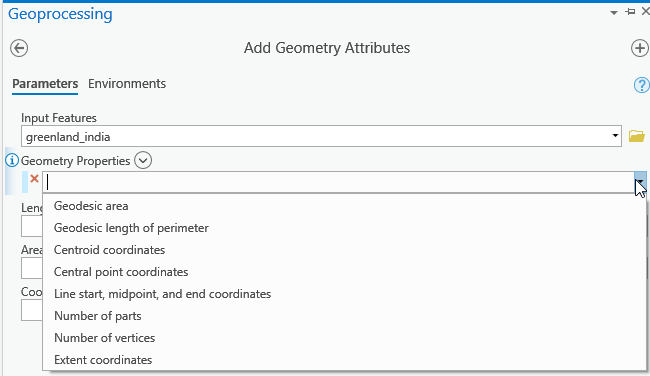
You can calculate planar and geodesic areas
Add Geometry Attributes—Data Management toolbox | ArcGIS Desktop
Drop the notion that geodesic is 'more accurate'. That completely depends on the size of the study area and the projection being used. If you are working on a province/state wide study, then the 'extents' are critical. Also, what do you mean by 'accurate' perhaps %age wise? Most projections that are used wisely, will have a specified value?.
Albers, Lambert Conformal conic... big areas... UTM less big (6 degree wide zone) MTM/State Plane smaller still (3 degree wide zone and 1/10,000 potential distance 'error')
Don't ignore the abstraction. It is important and widely overlooked.
To make things worse, they will try to measure things on Google Earth or AGOL using a 'webbie' projections like Web Mercator, which is the last thing one should use (but everyone uses it don't they !?!? )
Precision and accuracy... slippery concepts. How well do we really know the shape of earth? 1927 to 1983 big leap. New ones on the horizon? I suspect yes. It may improve locational precision, but a real reflection of land based distances... no, since distance will be a traversal along an ellipsoid.
Everything is an abstraction. That is what should be taught 
- Mark as New
- Bookmark
- Subscribe
- Mute
- Subscribe to RSS Feed
- Permalink
- Report Inappropriate Content
I 100% agree with 'everything is an abstraction'! I focus a lot of my material and exercises on demonstrating this.
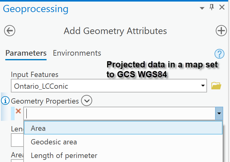
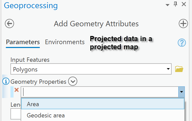
I think there might be some kind of glitch. If you have time, check out the attached images. I don't have the option to create planar calculations in ArcGIS Pro. You can see that the map's display CS is set to a projected one yet I only have the option to calculate area and perimeter geodesically.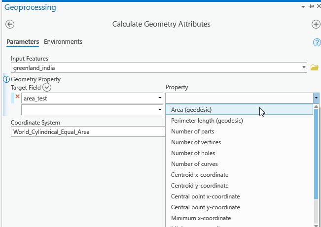
Here you can see that even using the tool you suggested, I don't have the option to create "planar" attribute fields.
(I have the map CS set to a projection.)
I've taught coordinate systems in ArcMap Desktop for 10 years. I'm learning ArcGIS Pro and switching my material over. From my experience with it (and the student who is working with me) it seemed as though ArcPro had done away with planar measurements, yet I found no mention of this on forums, documentation, etc. Seemed like a pretty big change. But now I'm wondering if there is something glitching with my system as you are telling me that geodesic should be an 'option' not the only choice...
Thoughts? Really appreciate your insights and comments, Dan.
- Mark as New
- Bookmark
- Subscribe
- Mute
- Subscribe to RSS Feed
- Permalink
- Report Inappropriate Content
Summary....
Geographic data in a projected map only allows for geodesic area calculation.
Projected data in a projected map (Canadian Lambert Conformal Conic) allows for both
Projected data in a geographic map (GCS WGS84).
It hasn't done away with planar measurements, it has restricted planar measures to planar data.
I kind of agree with this. If it is a bug, I like it .
My sentiment has always been if you need/want planar measures make sure you are working with planar data.
In fact the conversion of decimal degree data to projected data should entail densification.
Geodetic Densify—Data Management toolbox | ArcGIS Desktop
otherwise things like a portion of a UTM zone ( ie -78 to -72 long. by 42 to 48 labt.) gets distorted if you project it without densification. The longitudes will appear fine, but the north and south latitudes bands will not have the appropriate curvature unless you densify.
If people are relying on a planar calculation with geographic data, it shouldn't/can't properly happen without densification of the perimeter.
- Mark as New
- Bookmark
- Subscribe
- Mute
- Subscribe to RSS Feed
- Permalink
- Report Inappropriate Content
Dan Patterson wrote:
Projected data in a projected map (Canadian Lambert Conformal Conic) allows for both...
This does not seem to be the case for all PCS. For example, a Mercator projected data layer does not offer a planar area option in the Calculate Geometry Attributes tool. Yet, many other non-area preserving cylindrical coordinate systems like Miller do offer the planar area option. This seems to be true as of version 2.4.2.
Are there other PCS' for which the planar area option was omitted from the Calculate Geometry Attributes tool?