Turn on suggestions
Auto-suggest helps you quickly narrow down your search results by suggesting possible matches as you type.
Cancel
- Home
- :
- All Communities
- :
- Products
- :
- Geoprocessing
- :
- Geoprocessing Questions
- :
- Model Builder and Get Raster Properties -> Rast...
Options
- Subscribe to RSS Feed
- Mark Topic as New
- Mark Topic as Read
- Float this Topic for Current User
- Bookmark
- Subscribe
- Mute
- Printer Friendly Page
Model Builder and Get Raster Properties -> Raster Calculator
Subscribe
4254
6
02-24-2011 01:20 PM
02-24-2011
01:20 PM
- Mark as New
- Bookmark
- Subscribe
- Mute
- Subscribe to RSS Feed
- Permalink
- Report Inappropriate Content
In Model builder I am trying to use Get Raster Properties tool (ex. Min and Max) from the Data Management Toolbox and feed the output to the raster calculator to do raster math. Is that possible?
Otherwise, my solution may be to go to python scripting. Not very good at coding, any tips or script examples?
I am using ArcGIS v10.
Thanks.
Alice
Otherwise, my solution may be to go to python scripting. Not very good at coding, any tips or script examples?
I am using ArcGIS v10.
Thanks.
Alice
6 Replies
06-23-2011
07:21 AM
- Mark as New
- Bookmark
- Subscribe
- Mute
- Subscribe to RSS Feed
- Permalink
- Report Inappropriate Content
I've spent a long time try to do what you described but haven't had any luck. Did you ever get it to work?
07-06-2011
03:02 PM
- Mark as New
- Bookmark
- Subscribe
- Mute
- Subscribe to RSS Feed
- Permalink
- Report Inappropriate Content
I have been trying to accomplish the same thing. I'm going to post something to the Python scripting community.
Michelle
Michelle
07-06-2011
07:03 PM
- Mark as New
- Bookmark
- Subscribe
- Mute
- Subscribe to RSS Feed
- Permalink
- Report Inappropriate Content
If you use the get raster properties tool, you can create a bunch of different properties for grids (mean, median, std, etc). After those are generated, they show up as layers in the raster calculator when you are typing your equation. It's not as elegant as I was hoping for, but it works.
07-07-2011
09:09 AM
- Mark as New
- Bookmark
- Subscribe
- Mute
- Subscribe to RSS Feed
- Permalink
- Report Inappropriate Content
Thanks for the advise. I'll give it a shot.
09-07-2013
05:21 AM
- Mark as New
- Bookmark
- Subscribe
- Mute
- Subscribe to RSS Feed
- Permalink
- Report Inappropriate Content
This thread is old so maybe this has been solved elsewhere. Anyway, I found a way to accomplish this so I'd thought I'd post it here.
I simply put GetRasterProperties in a script-tool and set the output datatype to Double. That made the raster calculator able to handle the input. It seems the problem with GetRasterProperties tool is that it outputs it's value as Variant which makes RastCalc fail.
I simply put GetRasterProperties in a script-tool and set the output datatype to Double. That made the raster calculator able to handle the input. It seems the problem with GetRasterProperties tool is that it outputs it's value as Variant which makes RastCalc fail.
01-06-2016
12:31 AM
- Mark as New
- Bookmark
- Subscribe
- Mute
- Subscribe to RSS Feed
- Permalink
- Report Inappropriate Content
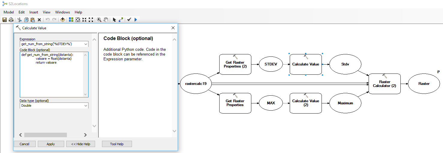
Solved!
An extra step in Model builder but it works.
Insert > Model Tools Only > Calculate Value; and simply add a short script that transforms the Output of the GetRasterProperties from Variant type to Double type [attached]. And than simply use the output from the Calculate Value tool inside the Raster Calculator.