- Home
- :
- All Communities
- :
- Industries
- :
- Science
- :
- Science Questions
- :
- Solar Radiation Tools -
- Subscribe to RSS Feed
- Mark Topic as New
- Mark Topic as Read
- Float this Topic for Current User
- Bookmark
- Subscribe
- Mute
- Printer Friendly Page
- Mark as New
- Bookmark
- Subscribe
- Mute
- Subscribe to RSS Feed
- Permalink
- Report Inappropriate Content
I want to calculate solar radiation at about 62 weather station points over Alaska. Eventually I want to calculate it at >1000 points. Alaska is a large area, and there is a wide variation in latitudes. I am looking for strategy ideas, or script suggestions!
#Solar Radiation
Solved! Go to Solution.
Accepted Solutions
- Mark as New
- Bookmark
- Subscribe
- Mute
- Subscribe to RSS Feed
- Permalink
- Report Inappropriate Content
What I ended up doing: I made a model that calculates the point insolation value sequentially. It also controls the latitude for each point, and the size of the Digital Elevation Model so that it works more efficiently than calculating the value with the entire state of Alaska.
This tool:
1) Builds a buffer from each value in the point file (Field Name: Buffer_m)
2) Clips a DEM to by the buffer size, setting Latitude and Extent values
3) Calculates the Insolation value for each point using the parameters in the Tool
4) Collects the values and merges them in a point file.
The Model has two layers. The Inner model Iterates through the point feature class, creating a buffer around each point, then clips the DEM to that buffer, and feeds the small DEM and the point to the Point Insolation Tool. The results of the tool are collected, and fed to the outer layer of the tool, which merges the points into a feature class. The input parameters (light blue) for the Point Insolation Tool have to be exposed at both levels, so that they can show up as input fields when the user “opens” the tool as opposed to “edits” it.
Outer Model Layer "Insolation Collector":
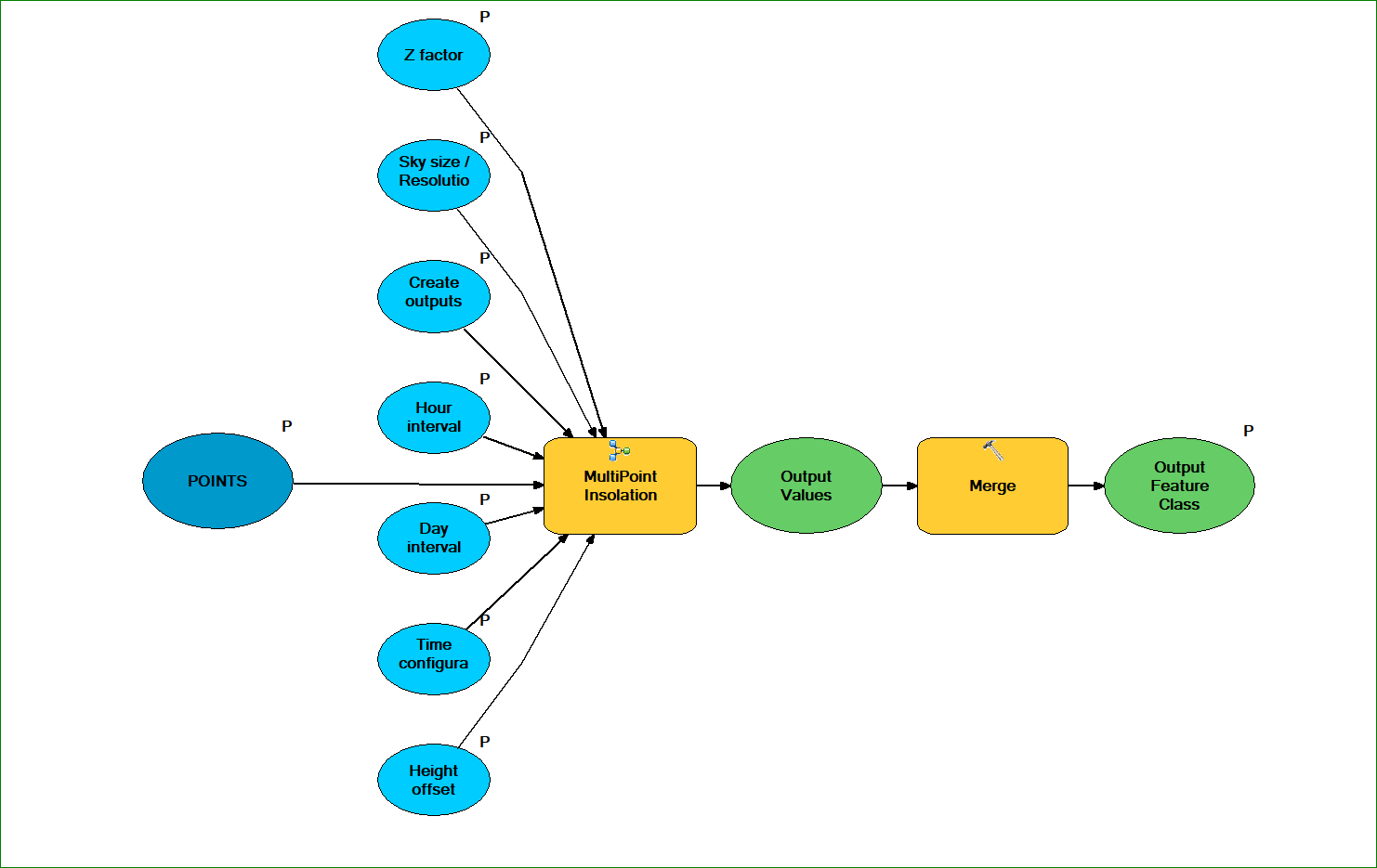
Inner Model Layer "MultiPoint Insolation":

Performance: Calculating the values for a set of 61 points takes about 10 minutes, with the Environment setting of using 88% for the “Parallel Processing Factor” setting. The grid size of the DEM was 60 meters – this makes a large difference how long it takes to finish.
There were some sticking points:
- Input Points must be in the same projection as the Digital Elevation Model, in meter units.
- Set Geoprocessing options so that
- “Overwrite the outputs” is set to YES, and
- “Add results of Geoprocessing Operations to the display” is set to NO
- Elements within the model also should not be set to “Add to the display.”
- Features that were not located on the DEM will not process, and the Output will have fewer features than the Input Feature Class.
At the end of processing the points, I joined the resulting table to the original feature class.
- Mark as New
- Bookmark
- Subscribe
- Mute
- Subscribe to RSS Feed
- Permalink
- Report Inappropriate Content
What I ended up doing: I made a model that calculates the point insolation value sequentially. It also controls the latitude for each point, and the size of the Digital Elevation Model so that it works more efficiently than calculating the value with the entire state of Alaska.
This tool:
1) Builds a buffer from each value in the point file (Field Name: Buffer_m)
2) Clips a DEM to by the buffer size, setting Latitude and Extent values
3) Calculates the Insolation value for each point using the parameters in the Tool
4) Collects the values and merges them in a point file.
The Model has two layers. The Inner model Iterates through the point feature class, creating a buffer around each point, then clips the DEM to that buffer, and feeds the small DEM and the point to the Point Insolation Tool. The results of the tool are collected, and fed to the outer layer of the tool, which merges the points into a feature class. The input parameters (light blue) for the Point Insolation Tool have to be exposed at both levels, so that they can show up as input fields when the user “opens” the tool as opposed to “edits” it.
Outer Model Layer "Insolation Collector":
Inner Model Layer "MultiPoint Insolation":
Performance: Calculating the values for a set of 61 points takes about 10 minutes, with the Environment setting of using 88% for the “Parallel Processing Factor” setting. The grid size of the DEM was 60 meters – this makes a large difference how long it takes to finish.
There were some sticking points:
- Input Points must be in the same projection as the Digital Elevation Model, in meter units.
- Set Geoprocessing options so that
- “Overwrite the outputs” is set to YES, and
- “Add results of Geoprocessing Operations to the display” is set to NO
- Elements within the model also should not be set to “Add to the display.”
- Features that were not located on the DEM will not process, and the Output will have fewer features than the Input Feature Class.
At the end of processing the points, I joined the resulting table to the original feature class.
- Mark as New
- Bookmark
- Subscribe
- Mute
- Subscribe to RSS Feed
- Permalink
- Report Inappropriate Content
Looks good!