- Home
- :
- All Communities
- :
- Products
- :
- ArcGIS for Office
- :
- ArcGIS for Office Questions
- :
- Unknown use of credits
- Subscribe to RSS Feed
- Mark Topic as New
- Mark Topic as Read
- Float this Topic for Current User
- Bookmark
- Subscribe
- Mute
- Printer Friendly Page
Unknown use of credits
- Mark as New
- Bookmark
- Subscribe
- Mute
- Subscribe to RSS Feed
- Permalink
- Report Inappropriate Content
I was having a play to test out the new Office Maps update. Somehow I've managed to use double the amount of credits we normally use in one day and not once did I see something that told me it would use credits or how many credits it would use.
I'm guessing it was the use of the report functionality?
I don't think we would be able to roll this out to our staff if there is no credit alert.
- Mark as New
- Bookmark
- Subscribe
- Mute
- Subscribe to RSS Feed
- Permalink
- Report Inappropriate Content
Hi Naomi,
Thank you for the post! I am sorry to hear that you are running into this issue. Could you please describe the workflow you are going through, and the report you are running? Is the data you are using to run the report in excel or hosted in AGOL?
Thank you!
- Mark as New
- Bookmark
- Subscribe
- Mute
- Subscribe to RSS Feed
- Permalink
- Report Inappropriate Content
Hi Jon
I've added layers to a map within Excel from my AGOL account. When I click on a feature within the popup there is table, infographics, report. So I click on report and I tried each of the 7 report styles available.
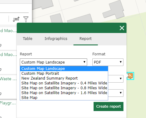
As a side note how to we adjust the format of a report that appears in here?
- Mark as New
- Bookmark
- Subscribe
- Mute
- Subscribe to RSS Feed
- Permalink
- Report Inappropriate Content
Hello Naomi,
If by format you mean .pdf or .dox, you may change this by selecting from your desired format from the format box at the right section of that box.
After doing some research, I have found this document. Here, I found this blurb: Using this functionality consumes ArcGIS service credits. To help you estimate how many credits you'll use, see Understand credits.
It seems that running these particular reports will gather information on the areas you have selected, thereby consuming credits. I would suggest that you let your user's know that this function may consume credits, and I would encourage you to send out this document to your workforce as well. Hope that helps!
- Mark as New
- Bookmark
- Subscribe
- Mute
- Subscribe to RSS Feed
- Permalink
- Report Inappropriate Content
Admittedly I am more likely to have a play and see what I can do rather than read all the documentation first (Its what happens when you guys make mapping so simple!). However in AGOL there is always the show credits button that happens before you run a tool. This would be really good to have this functionality in the Microsoft Maps plugin. 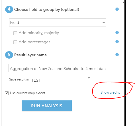
Sorry what I was meaning about changing the format (wrong word) was to change the actual layout of how the report looks. I thought this might be done in the 'Custom Map Portrait' etc but I cant actually see how we would create a layout which would have map or image boxes in some places text in other places however we would like to design it.
- Mark as New
- Bookmark
- Subscribe
- Mute
- Subscribe to RSS Feed
- Permalink
- Report Inappropriate Content
Hello Naomi, thanks for the reply. I think that both of your concerns are valid, and I would like to point you to our ArcGIS Ideas page. This is the best way of getting these issues in front of the ArcGIS maps for office team. You can find this page here: https://community.esri.com/community/arcgis-ideas
- Mark as New
- Bookmark
- Subscribe
- Mute
- Subscribe to RSS Feed
- Permalink
- Report Inappropriate Content
Thank you for the feedback Naomi! This concern is on our radar and we are looking forward to implementing a solution in an upcoming release. I apologize for the accrued credits while you were testing Maps for Office. In addition, I wanted to provide the link to our online resources regarding credit usage, see: Frequently asked questions—ArcGIS Maps for Office | ArcGIS
'Show credits' is provided for our Geocoding and enrichment services at this time.