- Home
- :
- All Communities
- :
- Products
- :
- ArcGIS Online
- :
- ArcGIS Online Questions
- :
- Check Credit Usage by AGOL Data Type
- Subscribe to RSS Feed
- Mark Topic as New
- Mark Topic as Read
- Float this Topic for Current User
- Bookmark
- Subscribe
- Mute
- Printer Friendly Page
- Mark as New
- Bookmark
- Subscribe
- Mute
- Subscribe to RSS Feed
- Permalink
- Report Inappropriate Content
I am curious if there is a way to check to see how many credits a WFS or Web App is consuming in a given time period. Our organization is having a hard time determining exactly which services/apps are eating most of our credits. We are burning through credits very quickly!
All of our credits are being used for storage.
Thanks in advance.
Solved! Go to Solution.
Accepted Solutions
- Mark as New
- Bookmark
- Subscribe
- Mute
- Subscribe to RSS Feed
- Permalink
- Report Inappropriate Content
Mitch,
It is likely that most of your credits are being used for storing feature layers. (Tile layers consume a much lower amount of credits per MB).
In ArcGIS Online go to Organization -> Credits -> View Status -> (Scroll Down, in the pie chart legend) Click on Storage -> Feature Storage -> Standard Feature Data Storage (in the table below the pie chart) -> and finally, click the "View Item Details" button below the table.
Hope that helps! For more information on how credits are consumed you can look at this page:
Understand credits—ArcGIS Online Help | ArcGIS
More specifically for your question, once you know which layers are consuming the most amount of credits, you can identify which apps or maps they are being used in. However, ArcGIS Online won't list which apps/maps are using credits because the apps/maps themselves don't consume credits. Only the layers that are within them do.
All the best,
Katherine
Katie
“The goal is not simply to ‘work hard, play hard.’ The goal is to make our work and our play indistinguishable.”
- Simon Sinek
- Mark as New
- Bookmark
- Subscribe
- Mute
- Subscribe to RSS Feed
- Permalink
- Report Inappropriate Content
Wow! Terrific answer, Katherine. Thanks so much!
- Mark as New
- Bookmark
- Subscribe
- Mute
- Subscribe to RSS Feed
- Permalink
- Report Inappropriate Content
Glad I could help! 
Katie
“The goal is not simply to ‘work hard, play hard.’ The goal is to make our work and our play indistinguishable.”
- Simon Sinek
- Mark as New
- Bookmark
- Subscribe
- Mute
- Subscribe to RSS Feed
- Permalink
- Report Inappropriate Content
If I might jump onto this question: Is there a way for a normal user to check on the storage used by his/her content? We try to make our staff aware of the usage of credits for what they store online so it would be good to see by themselves what is using how much without having the admin to investigate on it.
- Mark as New
- Bookmark
- Subscribe
- Mute
- Subscribe to RSS Feed
- Permalink
- Report Inappropriate Content
As far as I know, the interface I described is limited to admins. However, any user should be able to see the file size of the content they upload in the item details. So, individuals could calculate their credit usage by looking at the file size of the items they publish. Or, for example, since feature storage is 2.4 credits per 10 MB stored per month, the admin could encourage users not to publish any features larger than 5 MB or something.
At the very least I would recommend sharing the link I posted above about understanding credit usage to people within your organization.
Hope that helps!
Katie
“The goal is not simply to ‘work hard, play hard.’ The goal is to make our work and our play indistinguishable.”
- Simon Sinek
- Mark as New
- Bookmark
- Subscribe
- Mute
- Subscribe to RSS Feed
- Permalink
- Report Inappropriate Content
Thanks Katherine,
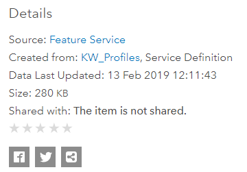
unfortunately I can only see that my feature service has e.g. 280 KB like in this example but it doesn't show me that the attachments in it have about 500MB. Even in the admin view I can only see the amount per feature service but for the attachments I can only see the total used storage, not to which feature service the data is attached...
- Mark as New
- Bookmark
- Subscribe
- Mute
- Subscribe to RSS Feed
- Permalink
- Report Inappropriate Content
Oh, good point! I hadn't thought about the feature attachments...you're correct that, even in admin view, I don't know of a way to single out which feature layers have a large amount of attachments. However, it might be some consolation that feature attachments only cost 1.2 credits for an entire GB, vs. the 2.4 credits per 10 MB of storage for feature storage.
Unfortunately, this seems like a situation again where the users just need to be educated about credit costs and be aware of how much they are publishing and attaching. I completely understand that this is easier said than done, though...
Looks like there's been an idea submitted for this already: https://community.esri.com/ideas/15526 I've upvoted it...let's spread the word! It seems like something that would be extremely useful for administrators and general users.
Katie
“The goal is not simply to ‘work hard, play hard.’ The goal is to make our work and our play indistinguishable.”
- Simon Sinek