- Home
- :
- All Communities
- :
- Products
- :
- Spatial Data Science
- :
- Spatial Data Science Questions
- :
- Best way to auto dimension district heating pipes
- Subscribe to RSS Feed
- Mark Topic as New
- Mark Topic as Read
- Float this Topic for Current User
- Bookmark
- Subscribe
- Mute
- Printer Friendly Page
Best way to auto dimension district heating pipes
- Mark as New
- Bookmark
- Subscribe
- Mute
- Subscribe to RSS Feed
- Permalink
- Report Inappropriate Content
Hi
I’m working on a GIS model that can auto dimension district heating pipes and would really like if any of you could help me finding the best practices/way to make the model. I’m a bit new to ArcGIS and especially network analysis. The model will be created in ArcGIS Model builder. I do not want to use the utility network in ArcGIS do to no available ArcGIS server license, which is required when using the utility network function (need an enterprise database).
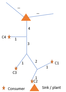
The concept is shown in the figure attached this question, where the model needs to calculate consumers from the end of the network towards the plant/sink in the network. Calculations need to be done on each line element based on summarized heat demand and number of connected consumers from the previous lines.
The questions are such:
- How to calculate each consumer connected to each line element i.e. assign the number from the figure to each line element
- how to summaries consumption from the consumer on each line element i.e. the pipe with number two should have an attribute with the sum of consumption from consumer C1 and C2.