- Home
- :
- All Communities
- :
- Products
- :
- ArcGIS GeoStatistical Analyst
- :
- ArcGIS GeoStatistical Analyst Questions
- :
- Exporting the cross validation file
- Subscribe to RSS Feed
- Mark Topic as New
- Mark Topic as Read
- Float this Topic for Current User
- Bookmark
- Subscribe
- Mute
- Printer Friendly Page
Exporting the cross validation file
- Mark as New
- Bookmark
- Subscribe
- Mute
- Subscribe to RSS Feed
- Permalink
- Report Inappropriate Content
Hi, Is there a way to export excel file for the cross validation process (indicated below in the image) only. Export option that is available at the bottom exports the interpolated values at the unsampled locations. However, I only need measured and predicted values at the sampled locations in order to calculate coefficient of determination (r2) for the kriged map.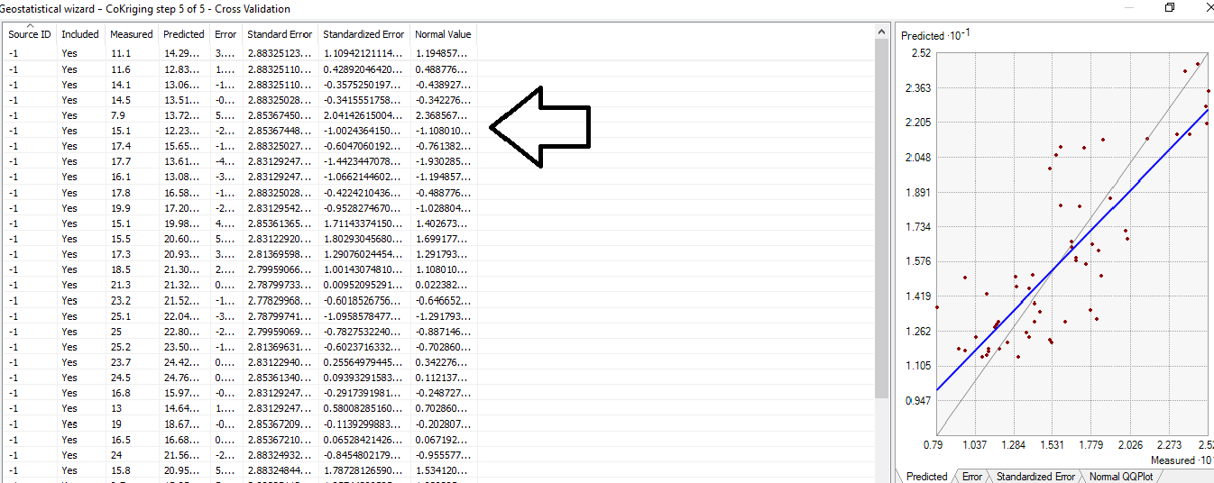
- Mark as New
- Bookmark
- Subscribe
- Mute
- Subscribe to RSS Feed
- Permalink
- Report Inappropriate Content
The "Export Result Table" button creates a feature class of the cross validation results at the sampled locations.

You can also use the CrossValidation geoprocessing tool to creates results at sampled and unsampled locations.
Also see more details here.
-Steve
- Mark as New
- Bookmark
- Subscribe
- Mute
- Subscribe to RSS Feed
- Permalink
- Report Inappropriate Content
Hi Steve,
Thanks for the reply. I am interested to export the table indicated in the image above. However, "Export result table" option available at the bottom of the crossvalidation window in geostatistical wizard creates result table for sampled and unsampled locations. However, I only need results for sampled points.
Any help in this regard would be appreciated.
Thanks,
- Mark as New
- Bookmark
- Subscribe
- Mute
- Subscribe to RSS Feed
- Permalink
- Report Inappropriate Content
Musfira
I'm confused.
The values in the Wizard are the sampled points.
-Steve
- Mark as New
- Bookmark
- Subscribe
- Mute
- Subscribe to RSS Feed
- Permalink
- Report Inappropriate Content
We have sampled 82 datapoints. However, "export result table" option generates file for 30,000 interpolated values. I only need predicted and measured values for the sampled dataset to calculate R2. How do I get that file?
- Mark as New
- Bookmark
- Subscribe
- Mute
- Subscribe to RSS Feed
- Permalink
- Report Inappropriate Content
You are doing cokriging.
- how many datasets?
- how many features in each dataset?
- format of the datasets, eg., shapefile, fgdb, raster, ...?
- what version of ArcGIS are you using?
-Steve
- Mark as New
- Bookmark
- Subscribe
- Mute
- Subscribe to RSS Feed
- Permalink
- Report Inappropriate Content
Hi Steve,
I am cokriging soil fertility as a function of different terrain covariates, and I have two datasets (soil fertility profile, and terrain covariates). Soil fertility profile has 6 fertility parameter, while LIDAR data has 5 terrain covariates. I have condensed both datasets into a single csv file, and I am using ArcGIS 10.5.1
- Mark as New
- Bookmark
- Subscribe
- Mute
- Subscribe to RSS Feed
- Permalink
- Report Inappropriate Content
Musfira
So how many rows are there in each .csv file and/or dataset (i.e. soil fertility profile, and terrain covariates)?
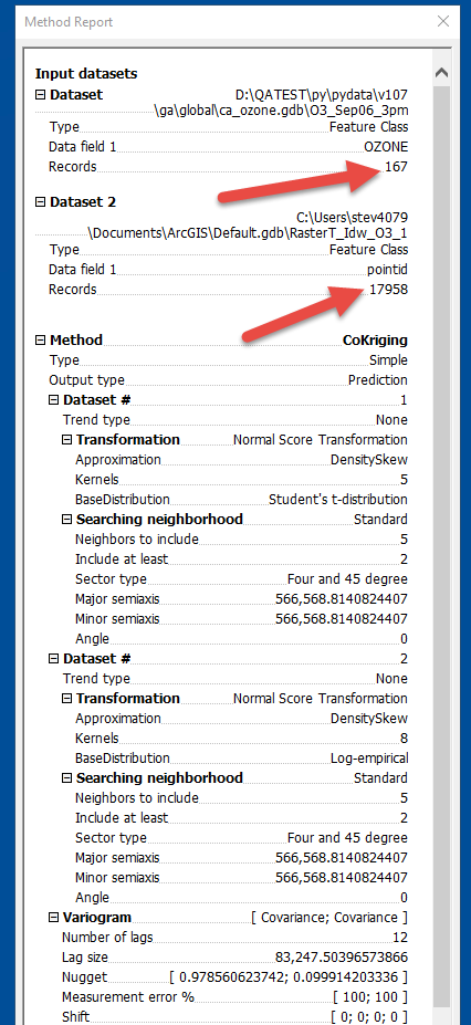
Please also include a screenshot of the "Method Report", i.e. the last dialog that appears before the Wizard closes.
-Steve
- Mark as New
- Bookmark
- Subscribe
- Mute
- Subscribe to RSS Feed
- Permalink
- Report Inappropriate Content
82 datapoints in soil fertilty profile, and 230,234 datapoints in terrain covariate dataset.
- Mark as New
- Bookmark
- Subscribe
- Mute
- Subscribe to RSS Feed
- Permalink
- Report Inappropriate Content
Please also include a screenshot of the "Method Report", i.e. the last dialog that appears before the Wizard closes, viz.,