- Home
- :
- All Communities
- :
- Products
- :
- ArcGIS Parcel Fabric
- :
- ArcGIS Parcel Fabric Questions
- :
- Traversing in Pro, can I increase the decimal plac...
- Subscribe to RSS Feed
- Mark Topic as New
- Mark Topic as Read
- Float this Topic for Current User
- Bookmark
- Subscribe
- Mute
- Printer Friendly Page
Traversing in Pro, can I increase the decimal places of input distance?
- Mark as New
- Bookmark
- Subscribe
- Mute
- Subscribe to RSS Feed
- Permalink
- Report Inappropriate Content
Hey,
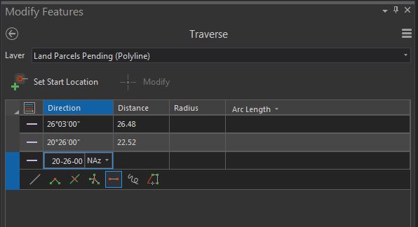
I am inputting a ton of traverse lines for new property boundaries, and I am inputting distances such as 18.005m, and it appears as though the software is clipping these distances to 18.00 in the input boxes of the traverse pane.
Does anyone know if I am able to increase these input boxes to display to 3 decimal place, instead of the default 2 decimals?
In this example I have inputted the distances 26.485 and 22.525, but it appears as thought the 0.005m are being ignored, I would like to display the full 3 decimals.
Any ideas if this is possible?
Cheers
Solved! Go to Solution.
Accepted Solutions
- Mark as New
- Bookmark
- Subscribe
- Mute
- Subscribe to RSS Feed
- Permalink
- Report Inappropriate Content
Ben, you'll have to change the numeric format of the distance unit you are working with.
Goto Project/options/units/distance units
click on the format cell for the unit you wish to change and set the number of decimals.
easy...
- Mark as New
- Bookmark
- Subscribe
- Mute
- Subscribe to RSS Feed
- Permalink
- Report Inappropriate Content
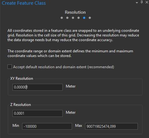
Do you know whether the resolution of your feature class or shapefile can handle that number of decimals (resolution)? The reason I ask is that when you create a new feature class, one is prompted to provide a resolution value for the xy coordinates. The finer the scale, the greater the accuracy, although there is an increase in the size of the feature class. I sometimes use the opposite to reduce the size of large feature classes where I do not require that level of accuracy.
So in the below example, I have the option for setting the resolution to a finer scale than the default value.
Do take a look at this help page, it explains it in more detail. The properties of a spatial reference—Geodatabases | ArcGIS Desktop
It is possible that your edited feature layer cannot store that many decimal values.
- Mark as New
- Bookmark
- Subscribe
- Mute
- Subscribe to RSS Feed
- Permalink
- Report Inappropriate Content
Ben, you'll have to change the numeric format of the distance unit you are working with.
Goto Project/options/units/distance units
click on the format cell for the unit you wish to change and set the number of decimals.
easy...
- Mark as New
- Bookmark
- Subscribe
- Mute
- Subscribe to RSS Feed
- Permalink
- Report Inappropriate Content
spot on, thanks Sean
- Mark as New
- Bookmark
- Subscribe
- Mute
- Subscribe to RSS Feed
- Permalink
- Report Inappropriate Content
@MervynLotter It is not recommended to touch the default XY resolution. I think it is around 1 mm by default, much more accurate than any survey grade measurements.
- Mark as New
- Bookmark
- Subscribe
- Mute
- Subscribe to RSS Feed
- Permalink
- Report Inappropriate Content
Dear AmirBar-Maor
I am sure you are right in 99% of the cases, but for some of my datasets, such as vegetation unit boundaries that are mapped at a national scale, even 0.5 meter accuracy would be sufficient and far more accurate than the input datasets. With thousands of polygons I find that reducing the resolution makes the dataset more portable and easy to share due to the smaller file size. Not everyone is working with survey grade measurements.
- Mark as New
- Bookmark
- Subscribe
- Mute
- Subscribe to RSS Feed
- Permalink
- Report Inappropriate Content
Reducing the number of vertices in your geometries will reduce their size with the default XY tolerance. We had a customer who reduced the XY resolution on their parcel data and it corrupted it. Like with image resolution, this process is not reversible.
Even with vegetation unit boundaries, you might think it's OK to reduce it, to later find out there is a gap between the vegetation and a natural boundary that is also used as a parcel boundary.
IMHO the XY Resolution is an 'implementation detail' that should have never been exposed.
Please be careful - your data is your greatest asset.