- Home
- :
- All Communities
- :
- Products
- :
- ArcGIS Online
- :
- ArcGIS Online Questions
- :
- My AOL map is seeing double.
- Subscribe to RSS Feed
- Mark Topic as New
- Mark Topic as Read
- Float this Topic for Current User
- Bookmark
- Subscribe
- Mute
- Printer Friendly Page
My AOL map is seeing double.
- Mark as New
- Bookmark
- Subscribe
- Mute
- Subscribe to RSS Feed
- Permalink
- Report Inappropriate Content
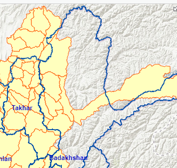
Does anyone recognize this behavior in this ArcGIS On Line map? I haven't given my map anything to drink, I swear! The yellow shaded layer has shifted west by 20 odd miles. The problem will usually fix itself for a while if I zoom or pan. Sometimes the borders will drop in latitude. The problem hasn't occurred yet when I access the map without having signed into my ARC account. I haven't monkeyed with the projection. Thanks for any insight!
- Mark as New
- Bookmark
- Subscribe
- Mute
- Subscribe to RSS Feed
- Permalink
- Report Inappropriate Content
Hi there,
My initial thought is that there is something off with the projection or transformation used
- What basemap service are you using?
- Is your web map publically available so we could have a look at it? If so, can you share the URL?
- What projection is your data in?
- How did you load your data to ArcGIS Online? Through ArcMap/ArcGIS Pro or a different method?
Carmel
- Mark as New
- Bookmark
- Subscribe
- Mute
- Subscribe to RSS Feed
- Permalink
- Report Inappropriate Content
Thanks so much for responding! Here is a link to the Story Map in which the map appears: https://arcg.is/1bOjGv The problem occurs, sporadically, on the second and third tabs. Here is a link to one of the problem web maps in the Story Map: https://arcg.is/15K9a9
I loaded the boundary data from shapefiles from a UN agency, in what was the current version of ArcGIS Pro about 8 months ago. I did some work to modify boundaries (I merged some polygons and split others). I'm hazy on the mechanics of how I got the boundary files from Pro to On Line. I sometimes created hosted layers in Pro and opened them in On Line, and sometimes created shapefiles in Pro that I opened in On Line. I believe that the projection was WSG84 and stayed WSG84 throughout. I'd mentioned earlier that the map always seemed to render properly when I wasn't signed in to my account, but am now also seeing the problem when I am signed in.
Would you suggest I try to fix the problem by deleting and recreating layers? Thanks!
- Mark as New
- Bookmark
- Subscribe
- Mute
- Subscribe to RSS Feed
- Permalink
- Report Inappropriate Content
Everything appears to align in regards to projection, all use wkid 102100 (WGS_1984_Web_Mercator_Auxiliary_Sphere).
Do you notice any issues if you try in other browsers (Internet Explorer, Firefox, Google Chrome)
Instead of signing in, does the issue appear if you choose Modify Map: 
There were issues with Hosted Features Services on the 30th Nov but nothing reported since: ArcGIS Online Health Dashboard
Carmel
- Mark as New
- Bookmark
- Subscribe
- Mute
- Subscribe to RSS Feed
- Permalink
- Report Inappropriate Content
Hello,
It appears that the layers are rendering at different speeds. Does this always happen when changing zoom levels? Is layer optimization enabled? How many vertices are there with each layer.
If the boundaries and symbology isn't updating, I'd suggest using tile layers as they can render complex geometry faster.
-Kelly
- Mark as New
- Bookmark
- Subscribe
- Mute
- Subscribe to RSS Feed
- Permalink
- Report Inappropriate Content
Forgive me for taking so long to reply. Your and Carmel's Questions, with my Answers:
Q. Does this always happen when changing zoom levels?
A. No, it only seems to be happening when I first open the map. Once I zoom or pan, the problem seems to be fixed and doesn't recur until I refresh the map, or click the Modify Map option in the upper left. And it doesn't always happen when you first open the map. (Based on only a half dozen attempts).
Q. Is layer optimization enabled?
A. Yes. Setting that didn't seem to change anything.
Q. How many vertices are there with each layer.
A. There are only two layers. The larger one has about 250,000 vertices. The smaller one maybe another 50,000. I think that counts as smallish, no?
Q. Do you notice any issues if you try in other browsers (Internet Explorer, Firefox, Google Chrome). I'm running Chrome. I tried opening the map from an incognito window on a Chromebook, and the problem did happen. I successfully opened the map on an Apple without the problem, but with only one attempt, so who knows.
Q. Instead of signing in, does the issue appear if you choose Modify Map: 
A. Yes. I was in incognito mode in a Chrome browser and opened the map. It happened to open up without any doubling problem, but went double when I clicked on Modify map.
Thank you both for having looked at this, and Richard for reassuring me that it wasn't all in my head!
- Mark as New
- Bookmark
- Subscribe
- Mute
- Subscribe to RSS Feed
- Permalink
- Report Inappropriate Content
I have been having the same issue with different hosted layers (polygon and line) drawing in web maps and story maps for over a week now. To avoid the shifting, I have been using Firefox instead of Chrome to make edits and view apps. The problem layers are in the correct projection, republished after having geometry repaired, and optimized. Customer service has been helping me, but still having issues. I am hoping its an update gone wrong in Chrome causing the issue.