- Home
- :
- All Communities
- :
- Industries
- :
- State & Local Government
- :
- State & Local Government Questions
- :
- Hi, I'm a newbie attempting to build a fire servic...
- Subscribe to RSS Feed
- Mark Topic as New
- Mark Topic as Read
- Float this Topic for Current User
- Bookmark
- Subscribe
- Mute
- Printer Friendly Page
Hi, I'm a newbie attempting to build a fire service map book. What inputs are necessary?
- Mark as New
- Bookmark
- Subscribe
- Mute
- Subscribe to RSS Feed
- Permalink
- Report Inappropriate Content
Hi guys, a mapping newbie/volunteer fire officer here. I'm attempting to create a fire run book using the "Fire Service Maps" add-on on ArcGIS PRO 2.2. Some really basic stuff is stumping me already.
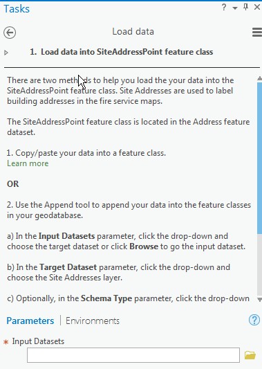
I did procure parcel outlines and Streets shapefiles from the county, but I don't know when/where to use them. I'm going through the tasks and I'm at "Load data into SiteAddressPoint feature class". Here's what it's giving me the option of doing:
I suppose I could just forge forward and try to see if the streets shapefile is able to be pulled in here, but I thought it'd be better if I asked first. And when should I import the parcel outlines shapefile?
Sorry for the newb question. (And I'm sure I'll have more to come!)
Thanks!
- Mark as New
- Bookmark
- Subscribe
- Mute
- Subscribe to RSS Feed
- Permalink
- Report Inappropriate Content
By Fire Run Book, I assume you are creating a map book of your area of response, correct?
A brief GIS primer first: geographic entities are represented by one of three basic shapes: Points, Lines, or Polygons. It sounds like the addin/task is asking to represent your site addresses as points. Your streets are obviously lines and your parcels are polygons.
Contact your county and see if they have actual address points. These are simply an x,y location with the address assigned to them. If your parcel polygons have a location or site address field, you can convert them to points: every polygon has a centroid location to it. See Feature To Point—Data Management toolbox | ArcGIS Desktop . The difference is address points typically represent the location of the actual residence, whereas the parcel centroid 'floats' somewhere inside the parcel.
- Mark as New
- Bookmark
- Subscribe
- Mute
- Subscribe to RSS Feed
- Permalink
- Report Inappropriate Content
Thanks Joe! Great info.
Yes, "Fire Service Maps" is a canned set of routines that ESRI put together to simplify making a "run book" and also wall maps for the fire service. Here's where they talk about it: Fire Service Maps | ArcGIS Solutions for Local Government
And prompted by your response, I looked in the folder containing the parcels shapefile (procured from county government for a reasonable cost!) and found a .dbf file. I opened it in access and I found a plethora of information about each parcel- like a couple hundred columns  . First column is the "Objectid" (which I assumes matches up to some sort of ID in the shapefile). Also (of course) included are LOC_NO with the numerics of the address, and LOC_STR and its companions LOC_SUF and LOC_SUF2. So at this point it seems (wild guess edition) that I can just point the task to the DBF and I'll be able to map the LOC_NO column into my target dataset? But now thinking it through I don't yet have a shapefile loaded to correlate the objectids of the shapefile with the objects in the .dbf....hummmm
- Mark as New
- Bookmark
- Subscribe
- Mute
- Subscribe to RSS Feed
- Permalink
- Report Inappropriate Content
Here is a thread discussing Fire Service Maps from another poster:
Fire Service Maps from ESRI Solutions for Local Gov't
One of the requirements for using this solution is
- ReportLab 3.4.0
which is an additional python module that you need to install. The python environment is not quite right and you need to perform some python cloning in order to perform this install that used to be much simpler. Below is one link amongst many about the python environment in Pro 2.2.x:
ArcGIS Pro 2.2.0 and Python Package Manager
Good luck with this setup and I hope this information is useful. I would be interested in hearing how this setup goes for you.
- Mark as New
- Bookmark
- Subscribe
- Mute
- Subscribe to RSS Feed
- Permalink
- Report Inappropriate Content
Thanks Michael! I haven't gotten that far yet , but I did see those 'warning shots' out there. I didn't see the second thread...that's really scary  . And it's so long it's hard to figure out what's the current proper advice and what is dated. Guess I'll have to jump off that bridge when I cross it...Extra scary, too, since I use python on a daily basis to automate the processing of our individual incident report...I'll keep you posted!!
- Mark as New
- Bookmark
- Subscribe
- Mute
- Subscribe to RSS Feed
- Permalink
- Report Inappropriate Content
Are you using python in Pro already as per your above statement? Have you had the need to install any non-default python modules up to this point?
- Mark as New
- Bookmark
- Subscribe
- Mute
- Subscribe to RSS Feed
- Permalink
- Report Inappropriate Content
No, no python in ArcGIS yet. In fact, other than the samples I created as part of the online training, this is my first foray into ArcGIS. The other python stuff is standalone.
- Mark as New
- Bookmark
- Subscribe
- Mute
- Subscribe to RSS Feed
- Permalink
- Report Inappropriate Content
A 'shapefile' is actually a series of files, one of which is <shapefile_name>.dbf. It's often referred to as the attribute table. More GIS 101: there are two components to the data. Geometry (point,line,polygon) and the attributes. Attributes are the I (information) of GIS.
The dbf table will not be enough to satisfy your needs. You need points as well....
- Mark as New
- Bookmark
- Subscribe
- Mute
- Subscribe to RSS Feed
- Permalink
- Report Inappropriate Content
Ah yes, thanks. I actually did go through some of the online training a while back (I'm now an expert on Amazonian Rainforests!) but shortly after I completed that I realized I needed the parcel data from the county GIS team...and by the time I got that and got back onto this project, most of what I had learned had flown the coop know as my head...
OK, I looked deeper in the .dbf. It appears as if the .dbf has no direct reference to the point. There are these things called SHAPE_STRe and SHAPE_STLe that I think point back to the objects in the parcels shaepfile. I wonder if there is any kind of routine that would interrogate the .dbf and .shp and can kick out point data??
Or is this something I need to go back and ask the county GIS guys about/for? They do list "custom programming" services when we order the data- I wonder if this was something we needed to ask for up front? Or maybe since they know that data they have a way to generate the points...
- Mark as New
- Bookmark
- Subscribe
- Mute
- Subscribe to RSS Feed
- Permalink
- Report Inappropriate Content
Duh, it seems like that's the routine that you linked me to in your first reply! Let me go off and investigate (and hope I'm licensed for that...)