- Home
- :
- All Communities
- :
- Industries
- :
- Water Utilities
- :
- Water Utilities Questions
- :
- Is it possible to automate sewer service line crea...
- Subscribe to RSS Feed
- Mark Topic as New
- Mark Topic as Read
- Float this Topic for Current User
- Bookmark
- Subscribe
- Mute
- Printer Friendly Page
Is it possible to automate sewer service line creation?
- Mark as New
- Bookmark
- Subscribe
- Mute
- Subscribe to RSS Feed
- Permalink
- Report Inappropriate Content
I am a GIS Tech working for a utility company, part of the asset maintenance program entails running a camera down gravity mains (sewer pipes) from the upstream manhole to the downstream manhole.
Every time the camera finds a sewer lateral (service line) it records its distance and the angle it leaves the gravity main.
I have been able to use ArcMap to plot the distances as points by converting the gravity mains to a route layer and using the create route events too on the original excel file given to me which contains the distances for each service line.
Now here is my main question - most of our gravity mains currently do not have the sewer laterals (service lines) digitized yet. With the location of the sewer lateral (point file) i also have the direction it leaves the gravity main.
Is it possible some how in arcpy to automate the creation of the sewer laterals, for example, just make all the sewer lines 20 ft and set a predetermined direction (the original points have an angle measurement for the sewer lateral direction relative to the direction of each of the gravity mains).
Could anyone give me any direction on how I might go about automating the creation of the sewer laterals
- Mark as New
- Bookmark
- Subscribe
- Mute
- Subscribe to RSS Feed
- Permalink
- Report Inappropriate Content
Yes, we have a tool in the Water Editing and Analysis toolset to do this:
 | Add Laterals from Line Locations | Evaluates selected point features (tap points) and draws a line (lateral) from each point perpendicular to the line (main) it intersects. Additional point (clean outs) features can be placed along the line (lateral). The point layer (tap points) requires a field to store the direction of the line (either as clock bearing or compass bearing); a field to store the direction the camera was traveling when recording the point (U for upstream and D for downstream); and a field with the length of the line (lateral) to create. You can define other settings for the points along the field to copy in the configuration file. |
I also would look at the CCTV Manager for plotting the tap points.
- Mark as New
- Bookmark
- Subscribe
- Mute
- Subscribe to RSS Feed
- Permalink
- Report Inappropriate Content
Your talking about the lateral point on the main which is picked up in the CCTV and drawing it back to snap to the parcel fabric or similar?
If so, yes it's possible, using python and arcpy it's pretty straight forward but requires ArcInfo. You have all the information needed from the CCTV inspections as long as your pipe network either has flow direction information or is drawn in the direction of flow.
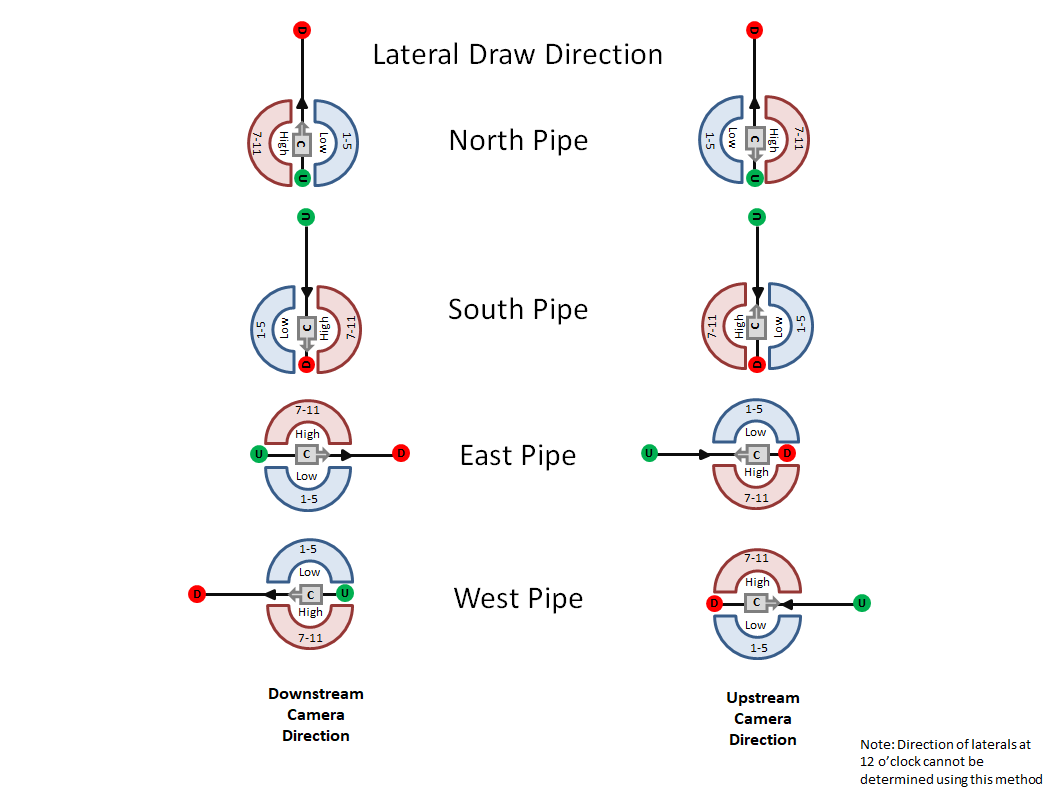
This infographic should help you get started how you can use the info in the CCTV inspections to draw the laterals.
C = The Camera facing direction
D = The downstream point
U = Upstream
Low 1-5 = Are the clock positions
High 7-11 = Clock positions
Note If you have lats at 12 o'clock you can't determine the direction unless you go look at the video and can see it going one way or the other
- Mark as New
- Bookmark
- Subscribe
- Mute
- Subscribe to RSS Feed
- Permalink
- Report Inappropriate Content
Tristan,
Thanks for the pointers, I figured it out in the end (very long winded but seemed to have worked fine given my lack of python skills!)
Basically I...
- Converted my gravity mains to a route layer (to ensure I get the correct flow direction).
- Use basic trig on the sewer tap points using the clock position to get bearing/direction and then from there I created a new point from the original tap point with the clock position bearing and a set default distance (40ft.) calculated into it. After that I just used the create line tool in Arc toolbox to create the lateral from the two points.
Trying to learn some python myself, would be interesting to see how this could be done in python? Did you do this with a script?
- Mark as New
- Bookmark
- Subscribe
- Mute
- Subscribe to RSS Feed
- Permalink
- Report Inappropriate Content
Oh nice glad you got it working. Yes it's all done in a python script, when the CCTV data comes in a I run the tool on all the data to output my laterals, if not perfect as it can get confused in curves of street sometime and intersects but it does like 90% of the work and will attribute the lats based on the info in the CCTV, I just have to QAQC it and then push it up.
- Mark as New
- Bookmark
- Subscribe
- Mute
- Subscribe to RSS Feed
- Permalink
- Report Inappropriate Content
Tristan,
I'm going to try and create a script for this myself, as my previous approach was very long winded and I'd like to avoid it in the future.
Quick question with regards to your script, does it use to bearing distance to line tool in arcmap?
- Mark as New
- Bookmark
- Subscribe
- Mute
- Subscribe to RSS Feed
- Permalink
- Report Inappropriate Content
It does not, thought you may be able to use it.
- Mine loops over each Pipe
- Gets the degrees of the pipe so I know what direction it's going in
- Get the compass angle of the degrees
- Get the compass alpha position (NESW)
- Select all Lats on that pipe
- Get the clock position of the Lat
- Get the draw direction (infographic above)
- Get a near table of features nearby
- Select the one that is in the correct draw direction
- Get the point location info of the near table
- Draw the line then attribute it based on the Lat point (Lat size, Status)
- Mark as New
- Bookmark
- Subscribe
- Mute
- Subscribe to RSS Feed
- Permalink
- Report Inappropriate Content
Tristan, thanks for the pointers!
- Mark as New
- Bookmark
- Subscribe
- Mute
- Subscribe to RSS Feed
- Permalink
- Report Inappropriate Content
Hi.. I have Water/Sewer Utilities CAD files for a county. I am converting the data from CAD to GIS layers. Now, I have manholes data (points) for a whole county and also have Gravity Main data (polylines) which were also converted from a CAD map. Now, I would like to have the flow direction information on Gravity Main data (in attribute fields). This information should include something like "From Manhole Number.... To Manhole Number ..." which inform us the direction of flow, and also helps us to name that particular section of gravity main line... ...Alternatively, if there is any an automated process that I can use to do a direct conversion of gravity main data from a CAD maps with flow direction information? I would highly appreciated if you guys have any suggestion and help!!! Thank you so much .
- Mark as New
- Bookmark
- Subscribe
- Mute
- Subscribe to RSS Feed
- Permalink
- Report Inappropriate Content
This a CAD map