- Home
- :
- All Communities
- :
- Products
- :
- ArcGIS Pro
- :
- ArcGIS Pro Questions
- :
- i still can not open my map in collector ?
- Subscribe to RSS Feed
- Mark Topic as New
- Mark Topic as Read
- Float this Topic for Current User
- Bookmark
- Subscribe
- Mute
- Printer Friendly Page
i still can not open my map in collector ?
- Mark as New
- Bookmark
- Subscribe
- Mute
- Subscribe to RSS Feed
- Permalink
- Report Inappropriate Content
Good evening - Please Help
I purchased a single users GIS package almost 3 weeks ago and still can not open my map in collector.
I am at the stage of publishing a service in the 'Share as Service' box.
I have followed the process and ended up at a point where i can go no further, because a box appears stating that 'you must fix the errors in your document'
See a screen shot of the box in question and a description of the errors.
Thanks eversomuch in advance for the help anyone can offer, it doesn't matter how small
The best of regards Mark Jackson
- Mark as New
- Bookmark
- Subscribe
- Mute
- Subscribe to RSS Feed
- Permalink
- Report Inappropriate Content
might be a good place to move your post to, or at least use the "Share" option (just don't double post)
- Mark as New
- Bookmark
- Subscribe
- Mute
- Subscribe to RSS Feed
- Permalink
- Report Inappropriate Content
Hi Mark,
Based on the screenshot that you attached, it looks like your map is missing a feature layer.
FYI: Collector for ArcGIS can only open and view web maps that contain at least one editable layer (e.g., a feature layer).
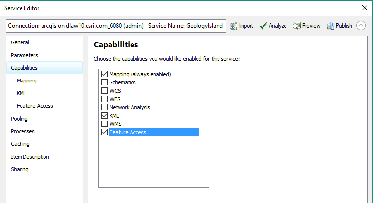
When you attempt to publish your map as a service, in the Service Editor dialog, please check Feature Access, under the Capabilities sub-tab. This will create a feature service for your data layer, which can be used as the editable layer in your web map for Collector.
FYI some resources:
- What is a feature service?—Documentation | ArcGIS Enterprise
- Prepare your data in ArcGIS Desktop—Collector for ArcGIS | ArcGIS (see the section called Publish Your Data)
Hope this helps,
- Mark as New
- Bookmark
- Subscribe
- Mute
- Subscribe to RSS Feed
- Permalink
- Report Inappropriate Content
Good Morning Derek
Thanks for the prompt response - it is much appreciated.
I have enabled the Feature Access as you suggested and ticked the
'Operations Allowed' boxes.
There appears to be another issue
When i go to 'Item Description' and 'choose my Tag' my Tag 'Fangorn2' is
not listed instead there is 'Fangorn' which is a previous attempt at a map
i created. - See Screen Shot
Have you any suggestions.
Thanks again for your help
Kind Regards
Mark
- Mark as New
- Bookmark
- Subscribe
- Mute
- Subscribe to RSS Feed
- Permalink
- Report Inappropriate Content
- Mark as New
- Bookmark
- Subscribe
- Mute
- Subscribe to RSS Feed
- Permalink
- Report Inappropriate Content
Hello Mark,
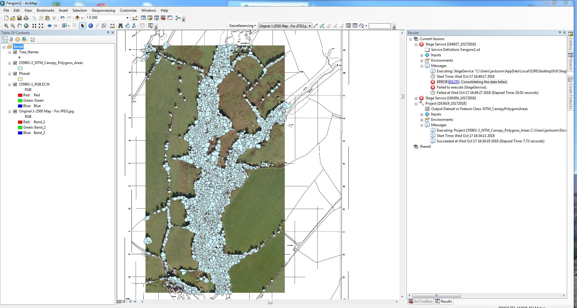
After looking over your additional screen captures I would like to refer to Derek's previous post. While Collector for ArcGIS requires at least one editable layer when you turn on the capability for "feature access" during the publishing process an actual feature class is required to work with the feature access capability. This information is documented in the resource documentation provided by Derek as well. Should you require additional troubleshooting it might be best to work through this with an Esri Support case.
I would also not recommend publishing the image (displayed in your screen capture) and feature class that will be used for editing to be included in the same published service.
- Mark as New
- Bookmark
- Subscribe
- Mute
- Subscribe to RSS Feed
- Permalink
- Report Inappropriate Content
Hi Mark,
> When i go to 'Item Description' and 'choose my Tag' my Tag 'Fangorn2' is not listed instead there is 'Fangorn' which is a previous attempt at a map i created
It might be that ArcMap's connection to ArcGIS Online has not refreshed the updated tags you've defined in ArcGIS Online. A quick fix would be to restart ArcMap and reconnect to ArcGIS Online.
> If i ignore the fact that Fangorn 2 is missing from the tags and just tick 'Fangorn' this is what happens - see screen shot.
As Dan Wade suggested, the error message in your new screen capture suggests the map document still does not contain an editable data layer to create a feature service. It looks like you only have imagery in the table of contents. I suggest you add a new feature layer (e.g., feature class) that contains editable data - this will create the feature service when you publish the map.
Hope this helps,
- Mark as New
- Bookmark
- Subscribe
- Mute
- Subscribe to RSS Feed
- Permalink
- Report Inappropriate Content
Hi,
Please make sure that when you shared your map online you made your data editable. Only editable web maps will be visible in Collector.
Kind regards,
Thomas Balstrøm
Dept. of Geoscience, Univ. of Copenhagen, Denmark
- Mark as New
- Bookmark
- Subscribe
- Mute
- Subscribe to RSS Feed
- Permalink
- Report Inappropriate Content
Mark,
It looks like you are using this for tree locations. What the previous folks are saying is correct. You have to add a something that is editable (a feature class). You only have a raster right now. Add the trees feature class that you are tying to map. Then just use the settings that have been suggested previously. That should work.
Larry
- Mark as New
- Bookmark
- Subscribe
- Mute
- Subscribe to RSS Feed
- Permalink
- Report Inappropriate Content
A big thankyou to all that offered a solution to my problem, Namely:
Dan Patterson
Thomas Balstrom
Larry Masters
Derek Law
Dan Wade
Adrian Welsh - you have all now helped me get 2 steps closer to publishing my map in Collector. However, it still won't open in collector - please see the attached error message, if indeed you still have the will to try and solve this issue.
Thanks eversomuch for your patience in advance.
The very best of regards Mark Jackson