- Home
- :
- All Communities
- :
- User Groups
- :
- Coordinate Reference Systems
- :
- Questions
- :
- Datum
- Subscribe to RSS Feed
- Mark Topic as New
- Mark Topic as Read
- Float this Topic for Current User
- Bookmark
- Subscribe
- Mute
- Printer Friendly Page
Datum
- Mark as New
- Bookmark
- Subscribe
- Mute
- Subscribe to RSS Feed
- Permalink
- Report Inappropriate Content
Hello,
I am using ArcMap 10.4.1.
I would like to match the datum between AutoCAD and ESRI ArcMap. However, I do not see the datum in the AutoCAD selections, comparing the WKT ESRI information and the AutoCAD options. The coordinate system I am looking for in ArcMap is designated as LL84 in AutoCAD, which is the WGS84 coordinate reference system, but do not see the flattening value matching. Is there a better way I can search for the correct datum/coordinate reference system that will match AutoCAD?
Solved! Go to Solution.
Accepted Solutions
- Mark as New
- Bookmark
- Subscribe
- Mute
- Subscribe to RSS Feed
- Permalink
- Report Inappropriate Content
Chuck
go to this link... there is one for projected coordinate systems as well
http://desktop.arcgis.com/en/arcmap/latest/map/projections/pdf/geographic_coordinate_systems.pdf
- Mark as New
- Bookmark
- Subscribe
- Mute
- Subscribe to RSS Feed
- Permalink
- Report Inappropriate Content
WGS 84: EPSG Projection -- Spatial Reference is a geographic coordinate system, aka unprojected
the inverse flattening is about 298
GEOGCS["WGS 84",
DATUM["WGS_1984",
SPHEROID["WGS 84",6378137,298.257223563, AUTHORITY["EPSG","7030"]], AUTHORITY["EPSG","6326"]],
PRIMEM["Greenwich",0, AUTHORITY["EPSG","8901"]],
UNIT["degree",0.01745329251994328, AUTHORITY["EPSG","9122"]], AUTHORITY["EPSG","4326"]]
- Mark as New
- Bookmark
- Subscribe
- Mute
- Subscribe to RSS Feed
- Permalink
- Report Inappropriate Content
Dan,
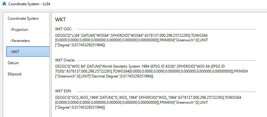
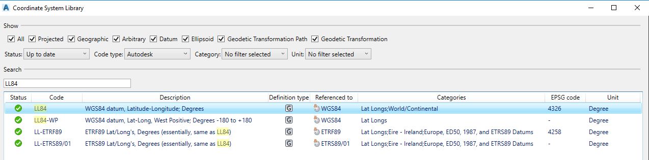
Thanks again for your help. I did find the correct datum but I notice that the flattening is not the same as what Autodesk reports, see attached screen shots. However, the EPSG code matches and the imported aerial imagery appears to align with the site correctly. For my own understanding, is there a way I can search in ArcMap for the EPSG code when trying to match between Autocad or MicroStation to ESRI AcrMap?
- Mark as New
- Bookmark
- Subscribe
- Mute
- Subscribe to RSS Feed
- Permalink
- Report Inappropriate Content
- Mark as New
- Bookmark
- Subscribe
- Mute
- Subscribe to RSS Feed
- Permalink
- Report Inappropriate Content
Chuck
go to this link... there is one for projected coordinate systems as well
http://desktop.arcgis.com/en/arcmap/latest/map/projections/pdf/geographic_coordinate_systems.pdf