- Home
- :
- All Communities
- :
- Products
- :
- ArcGIS Drone2Map
- :
- ArcGIS Drone2Map Questions
- :
- 'Create Orthomosaic' is checked in Processing Opti...
- Subscribe to RSS Feed
- Mark Topic as New
- Mark Topic as Read
- Float this Topic for Current User
- Bookmark
- Subscribe
- Mute
- Printer Friendly Page
'Create Orthomosaic' is checked in Processing Options, but none is actually created
- Mark as New
- Bookmark
- Subscribe
- Mute
- Subscribe to RSS Feed
- Permalink
- Report Inappropriate Content
Hey everyone,
I'm using a d2m trial, and am having trouble getting it to create my orthomosaic. 'Create Orthomosaic' and 'Merge Tiles' are checked in processing options, I can watch it being processed in the Processing Log without any errors, but no ortho is actually added to the project, nor is it anywhere to be found in my project folder.
The processing report shows a preview of everything as it should look, including the ortho, but only the DSM and DTM are actually created and added to the project.
In case any of this helps:
- I'm running on Drone2Map 1.3.1.226
- The project is 133 images (1.11gb)
- Images were taken by a Mavic Air, and the flight plan was drawn up using Pix4D Capture
- Average GSD is 2.04 cm
Has anyone else run into this issue / know how to fix it?
Thanks!
Solved! Go to Solution.
Accepted Solutions
- Mark as New
- Bookmark
- Subscribe
- Mute
- Subscribe to RSS Feed
- Permalink
- Report Inappropriate Content
After working with ESRI tech support, the (correct) conclusion was made that our UAV needed to be re-calibrated after imagery from other drones created an orthomosaic and everything else just fine.
- Mark as New
- Bookmark
- Subscribe
- Mute
- Subscribe to RSS Feed
- Permalink
- Report Inappropriate Content
Interesting. Usually it's the other way around for me with the elevation raster not coming through...
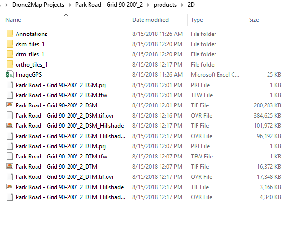
Here's a screen shot of what is normally in your project's "products" folder:

- Mark as New
- Bookmark
- Subscribe
- Mute
- Subscribe to RSS Feed
- Permalink
- Report Inappropriate Content
This is what I'm getting - Everything looks the same as yours, just without the actual ortho files. It does create the "ortho_tiles" folder, but it's totally empty.
- Mark as New
- Bookmark
- Subscribe
- Mute
- Subscribe to RSS Feed
- Permalink
- Report Inappropriate Content
Hmmm..that is odd. Are you missing orthos after a Rapid project as well? You may try uninstall/reinstall process. I had this happen to me on an older D2M release, but I haven't seen the issue since.
- Mark as New
- Bookmark
- Subscribe
- Mute
- Subscribe to RSS Feed
- Permalink
- Report Inappropriate Content
No orthos to be seen for rapid or more intensive projects, even after a full reinstall. I had our IT guy take a look too, and it doesn't look like anything is getting blocked by the firewall / server security settings. 
- Mark as New
- Bookmark
- Subscribe
- Mute
- Subscribe to RSS Feed
- Permalink
- Report Inappropriate Content
So when you are in one of your projects, do see any images when click on the blue photo dot? Are you modifying any of the Processing Options?
This may sound silly, but try using some simple naming for both the folder and project names with no spaces or special characters. Are you accessing and saving data locally on your machine? Call the folder 'test' and call the project like 'testproj' or something like that and rerun.
I'll compare your report with one of mine to see if anything stands out.
- Mark as New
- Bookmark
- Subscribe
- Mute
- Subscribe to RSS Feed
- Permalink
- Report Inappropriate Content
All images are there when I click the blue dots, and no processing options have been modified. The simplified naming was a good idea, but unfortunately I got the same results as before for both rapid and full processing.
- Mark as New
- Bookmark
- Subscribe
- Mute
- Subscribe to RSS Feed
- Permalink
- Report Inappropriate Content
After working with ESRI tech support, the (correct) conclusion was made that our UAV needed to be re-calibrated after imagery from other drones created an orthomosaic and everything else just fine.
- Mark as New
- Bookmark
- Subscribe
- Mute
- Subscribe to RSS Feed
- Permalink
- Report Inappropriate Content
Hey Mark,
I am experiencing the exact same behavior with Drone2Map when using my Mavic Air. Could you provide any more details about what specifically you had to configure on the drone. Was this configuration done in the DJI Go App or on the PIX4D software?
- Mark as New
- Bookmark
- Subscribe
- Mute
- Subscribe to RSS Feed
- Permalink
- Report Inappropriate Content
I'm having the same issue. Could you elaborate on what the setting is that needs to be changed on the UAV?
Thank you!