- Home
- :
- All Communities
- :
- Products
- :
- ArcGIS Pro
- :
- ArcGIS Pro Questions
- :
- Not wysiwyg? Export from Layout not what's rendere...
- Subscribe to RSS Feed
- Mark Topic as New
- Mark Topic as Read
- Float this Topic for Current User
- Bookmark
- Subscribe
- Mute
- Printer Friendly Page
Not wysiwyg? Export from Layout not what's rendered in Pro?
- Mark as New
- Bookmark
- Subscribe
- Mute
- Subscribe to RSS Feed
- Permalink
- Report Inappropriate Content
I have a layout that's 6'x4' large with world imagery basemap in it.
The imagery I get in the layout differs from what I get in the PDF. The geolocation is fine, it is the rendering that I am questioning. It appears it is sourcing different imagery due to zoom level, but should this be expected?
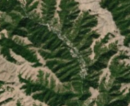
If I see this in layout
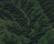
shouldn't I be expecting it in PDF output and not this?
I've tried with EMF format, and received the same result.
Any suggestion? Thanks.
Solved! Go to Solution.
Accepted Solutions
- Mark as New
- Bookmark
- Subscribe
- Mute
- Subscribe to RSS Feed
- Permalink
- Report Inappropriate Content
Thanks to Dan, Kory and Steve. This issues has been logged as Bug ID: BUG-000116338
- Mark as New
- Bookmark
- Subscribe
- Mute
- Subscribe to RSS Feed
- Permalink
- Report Inappropriate Content
Export a map or layout—ArcGIS Pro | ArcGIS Desktop
did you set any advanced options for pdf?
do you need vector format? png has a variety of options as well
- Mark as New
- Bookmark
- Subscribe
- Mute
- Subscribe to RSS Feed
- Permalink
- Report Inappropriate Content
Thanks Dan. No advance setting.
I set up the page size, insert the map frame, zoom to the desired zoom level, then share/export
- Mark as New
- Bookmark
- Subscribe
- Mute
- Subscribe to RSS Feed
- Permalink
- Report Inappropriate Content
William. In a map where you only have the imagery basemap added as a layer, can you create a Bookmark of the area you're exporting? Then save a .mapx and share that with us? I think this will give us the bookmark of the extent where you're working.
Thanks
- Mark as New
- Bookmark
- Subscribe
- Mute
- Subscribe to RSS Feed
- Permalink
- Report Inappropriate Content
Also, since Best is the default Image Quality, can you confirm that you are exporting at that Best quality?
- Mark as New
- Bookmark
- Subscribe
- Mute
- Subscribe to RSS Feed
- Permalink
- Report Inappropriate Content
I wonder if your map scale puts you on the border of one of the imagery basemap's level of detail thresholds where it switches from one acquisition to the next level. That could explain why the imagery looks so distinctly different.
I haven't experienced this specifically but I did experience a situation where I tried to export my Pro Scene as a JPEG and the resulting JPEG showed more area than I was seeing on my screen extent (hence Pro was altering the map extent on its own accord). My example:
Screenshot of app view:

Resulting export:
Clearly the map extent was altered but not by me. I wonder if you're experiencing something similar?..
- Mark as New
- Bookmark
- Subscribe
- Mute
- Subscribe to RSS Feed
- Permalink
- Report Inappropriate Content
Hi Steve,
When i looked at the world imagery in map frame, it does not appear to close to the border hence my confusion. Since my posting, my intern was able to export out and she got what was rendered in the layout using the same aprx. I also tried using other colleague's pc and got the same result as layout. Tested again on my machine, I got a different imagery. I suspect there is a setting issue going on
- Mark as New
- Bookmark
- Subscribe
- Mute
- Subscribe to RSS Feed
- Permalink
- Report Inappropriate Content
Thanks to Dan, Kory and Steve. This issues has been logged as Bug ID: BUG-000116338