- Home
- :
- All Communities
- :
- Products
- :
- ArcGIS Pro
- :
- ArcGIS Pro Questions
- :
- Raster Analysis is greyed out
- Subscribe to RSS Feed
- Mark Topic as New
- Mark Topic as Read
- Float this Topic for Current User
- Bookmark
- Subscribe
- Mute
- Printer Friendly Page
- Mark as New
- Bookmark
- Subscribe
- Mute
- Subscribe to RSS Feed
- Permalink
- Report Inappropriate Content
This is driving me crazy...
I am trying to perform a simple shaded relief on a surface, but the Analysis > Raster Analysis keeps graying out indicating: You must be connected to a portal with raster analysis tools.
If I try to run it as a Raster Function, it reports: Failed to apply Shaded Relief
I am running Pro as a concurrent license, not a named user.
I have Spatial Analyst authorized and enabled.
I am connected to our corporate AGOL account: https://<companname>.maps.arcgis.com/
What am I missing?!?!
Solved! Go to Solution.
Accepted Solutions
- Mark as New
- Bookmark
- Subscribe
- Mute
- Subscribe to RSS Feed
- Permalink
- Report Inappropriate Content
Let's make this a little more visual... If you are referring to Raster Analysis in the Portal section:
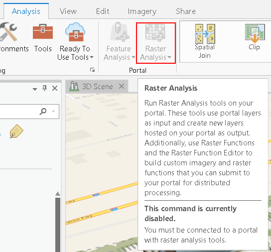
... this capability is available for those users that have ArcGIS Enterprise with the Image Server role and set up the Raster Analysis in their Portal. See: Configure and deploy ArcGIS Enterprise for raster analytics—Portal for ArcGIS (10.6) | ArcGIS Enterp... This is not related to the Spatial Analyst extension that might be assigned to you.
You also mention Raster Functions:

... this is a function applied to raster datasets for visualization and only processes those pixels visible on the screen. This should be available to you:
I normally load my DTM/DSM into a mosaic dataset and predefine some raster functions (see image below), but you can use this option to visualize your data. See: Raster functions—ArcGIS Pro | ArcGIS Desktop

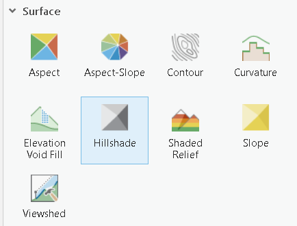
If you want to create a new raster using the Hillshade geoprocessing tool, you should use:
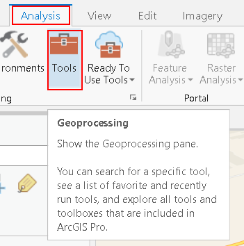
... and search for Hillshade and open the tool:

and execute the tool with the appropriate settings.
Please also verify if the extension is available to you by entering the Project pane and choose Licensing:

- Mark as New
- Bookmark
- Subscribe
- Mute
- Subscribe to RSS Feed
- Permalink
- Report Inappropriate Content
why do you have to use the online versions if you have the spatial analyst?
Hillshade—Help | ArcGIS Desktop
by another name... everything and more is still in ArcToolbox
unless of course your data is in your portal (or whatever)
An overview of the Raster Analysis toolbox—RasterAnalysis Tools | ArcGIS Desktop
- Mark as New
- Bookmark
- Subscribe
- Mute
- Subscribe to RSS Feed
- Permalink
- Report Inappropriate Content
Well, I guess I'm just not understanding 'the platform' then...
Yes, Hillshade from SA or 3DA work fine, but I'm looking for the equivalent of the Image Analysis window in ArcMap and thought these tools were that, but obviously not. I just don't understand how I could use these surface tools in ArcMap but now not in in Pro? This has to be a licensing/configuration issue?
And here I thought I might be getting close to making the move to Pro...
W.
- Mark as New
- Bookmark
- Subscribe
- Mute
- Subscribe to RSS Feed
- Permalink
- Report Inappropriate Content
Warren... search help using Hillshade… it is all over the place.
Here is another Hillshade function—ArcGIS Pro | ArcGIS Desktop and Shaded Relief function—ArcGIS Pro | ArcGIS Desktop and for some extra 'pop'
Multi-Directional Hillshade Makes Your Maps Pop | ArcUser
Depends where your data resides, you licensing and what you want to do with it.
An overview Get started with image and raster processing—ArcGIS Pro | ArcGIS Desktop
- Mark as New
- Bookmark
- Subscribe
- Mute
- Subscribe to RSS Feed
- Permalink
- Report Inappropriate Content
Let's make this a little more visual... If you are referring to Raster Analysis in the Portal section:
... this capability is available for those users that have ArcGIS Enterprise with the Image Server role and set up the Raster Analysis in their Portal. See: Configure and deploy ArcGIS Enterprise for raster analytics—Portal for ArcGIS (10.6) | ArcGIS Enterp... This is not related to the Spatial Analyst extension that might be assigned to you.
You also mention Raster Functions:
... this is a function applied to raster datasets for visualization and only processes those pixels visible on the screen. This should be available to you:
I normally load my DTM/DSM into a mosaic dataset and predefine some raster functions (see image below), but you can use this option to visualize your data. See: Raster functions—ArcGIS Pro | ArcGIS Desktop
If you want to create a new raster using the Hillshade geoprocessing tool, you should use:
... and search for Hillshade and open the tool:
and execute the tool with the appropriate settings.
Please also verify if the extension is available to you by entering the Project pane and choose Licensing:
- Mark as New
- Bookmark
- Subscribe
- Mute
- Subscribe to RSS Feed
- Permalink
- Report Inappropriate Content
Thanks for the explanation Xander.
The Raster Functions are working now so I'm thinking the SA license wasn't available when I was attempting this yesterday. SO to clarify then, our corporate AGOL organizational account is not a 'portal' in the context of these tools?
- Mark as New
- Bookmark
- Subscribe
- Mute
- Subscribe to RSS Feed
- Permalink
- Report Inappropriate Content
The Raster Analytics functionality is something that is only available for those users that have ArcGIS Enterprise with the Image Server role installed and properly configured. This is not available through ArcGIS Online.