- Home
- :
- All Communities
- :
- Products
- :
- ArcGIS Network Analyst
- :
- ArcGIS Network Analyst Questions
- :
- The delay time on Barriers is not added to Travel ...
- Subscribe to RSS Feed
- Mark Topic as New
- Mark Topic as Read
- Float this Topic for Current User
- Bookmark
- Subscribe
- Mute
- Printer Friendly Page
The delay time on Barriers is not added to Travel Time when finding the closest facility
- Mark as New
- Bookmark
- Subscribe
- Mute
- Subscribe to RSS Feed
- Permalink
- Report Inappropriate Content
Dear Sir,
My name is Fuad Ishaq and I live in the West Bank, Palestine where movement and Transportation are restricted and affected by different type of barriers, I created a Network Dataset to run the analysis to examine the effects off different type off barriers such as: Checkpoints, Roadblocks, Earth mound, Wall Barriers, Road Gates etc. on economy and the real cost on transportation …so I constructed the Network Dataset from Road System and add the Roads Checkpoints as Barriers with delay time as added cost, I created the closest facility analysis layer, the purpose of this Network is to calculate the drive time it takes to travel from locality A to B through these barriers by adding the delay time to travel time. The problem is that the system doesn’t adding the delay time to travel time.
The delay time value is stored in a field located in the Checkpoint Barrier Layer, its name is Attr_TravelTime .
Inside the Road System feature class there is a field called TravelTime .
Other thing, when creating the barrier using the Network Analyst “create Network location Tool” and run the solve button it adds the delay time to travel time but when I Load the Barriers from feature class or other shapefile it will not add the delay time to Travel time ,, so what’s the problem ???
I need your help to figure out why it’s not adding the delay time to travel time, thanks...
- Mark as New
- Bookmark
- Subscribe
- Mute
- Subscribe to RSS Feed
- Permalink
- Report Inappropriate Content
Faud,
Since the values are working when you use the create network location tools, then most likely when you use Load Locations, some setting is not being set so that the attr_traveltime values are not being loaded into the barriers. See my screen shot. Make sure on the Load Locations, the Barrier type is set to Added Cost and that the Attr_TravelTime property is mapped to the field Attr_TravelTime. After the load, open the attribute table for the barriers and make sure the right values are loaded. Then also make sure that you are solving the CF layer using the TravelTime attribute and that the values you loaded are meaningful. For example, if the units are minutes for TravelTime, the delay from the point barrier layer is also in minutes.

Jay Sandhu
- Mark as New
- Bookmark
- Subscribe
- Mute
- Subscribe to RSS Feed
- Permalink
- Report Inappropriate Content
Jay Sandhu
Thanks for your message, I added the TravelTime as you suggested (see attached file “Load Locations.jpg”) but still facing the same problem, it works fine for graphics points (see the Result Table.jpg for the Route) but not if I load the locations.
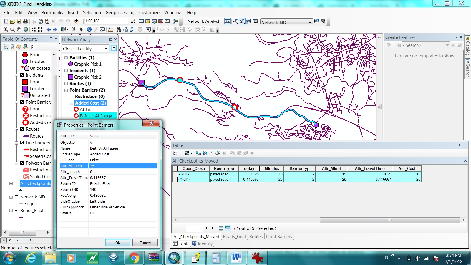
I deleted the network data set and built it again so as to add the “Attr_TravelTime” property , the “Attr_TravelTime” reads its value from the Field located in the Roads layer its name is “DriveTime”, I mapped it to this field during defining the Network Attributes , I sent you several attached files for the Roads feature Table ,Route Table (Result Table.jpg), Barriers Table and the Checkpoint Feature Class Table , hope it will help solving my problem and really I appreciate your help , thanks
Fuad
1) Solving using Graphic locations
Closest Facility Layer Property "The Accumulation Attributes"
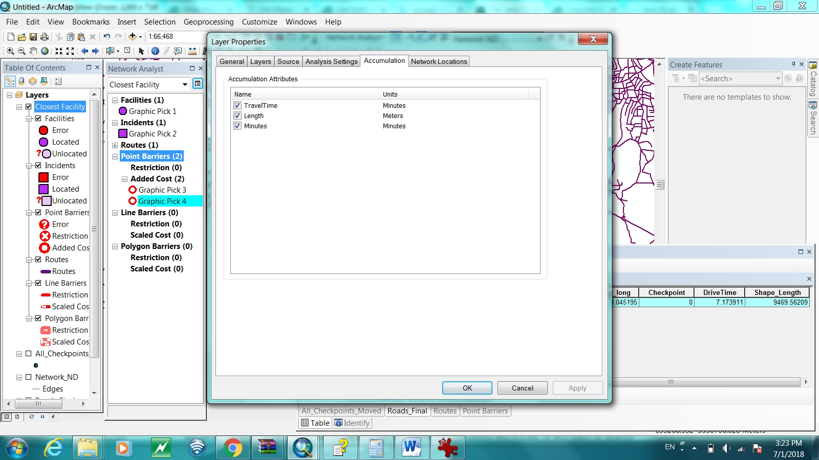
Closest Facility Layer Property "Analysis Settings"

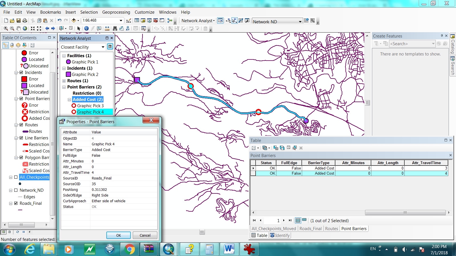
Graphic Point Barriers Table
Roads Table , you can find the DriveTime Field

The Result from using graphic locations and its correct, the delay time is added to travelTime
2) Solving using locations loaded from Feature Class
Load Locations for the Checkpoint Feature Class
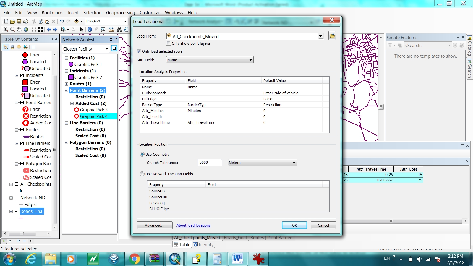
Barriers loaded from Checkpoint feature class and the system recognize them as a added cost property
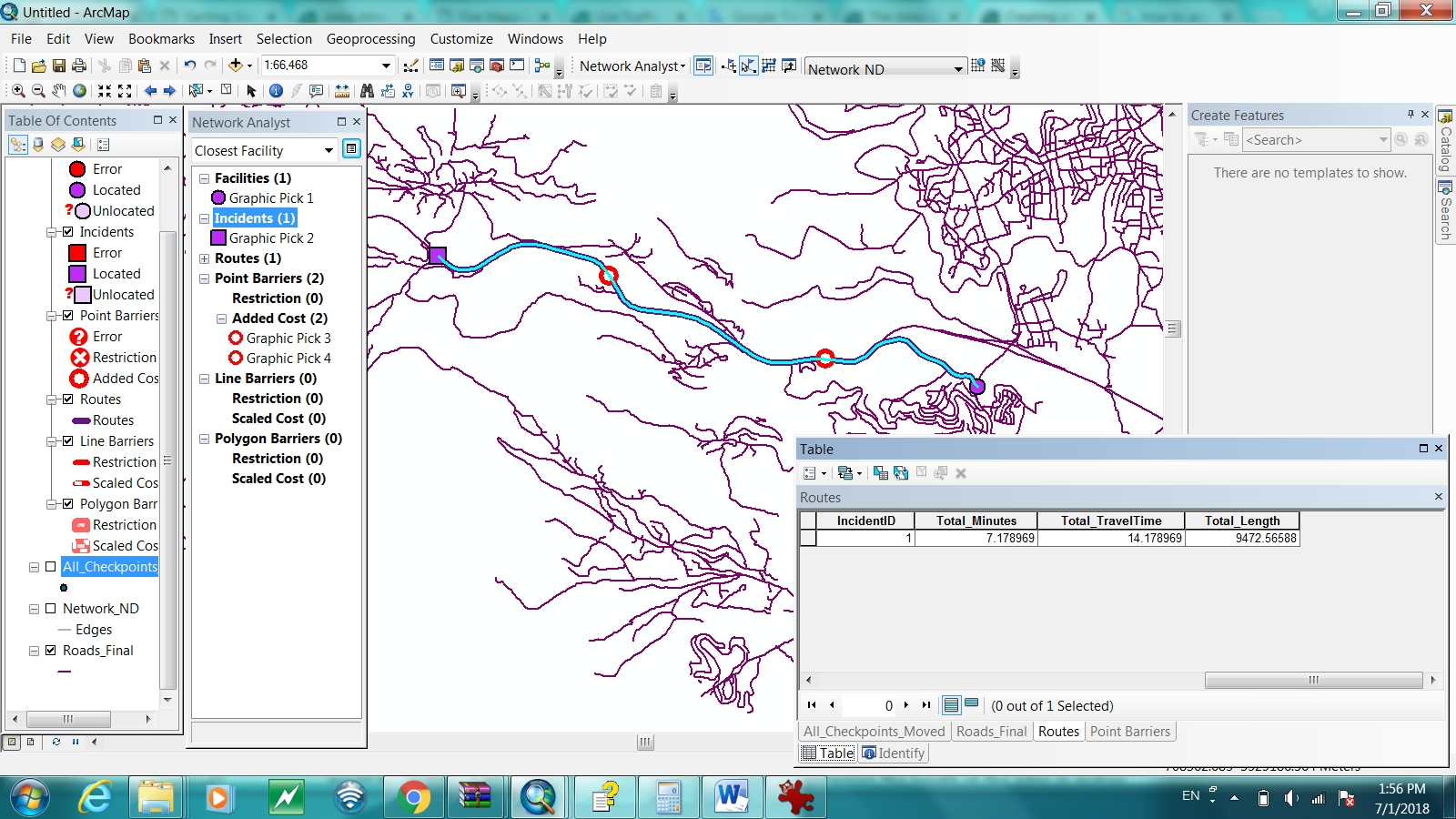
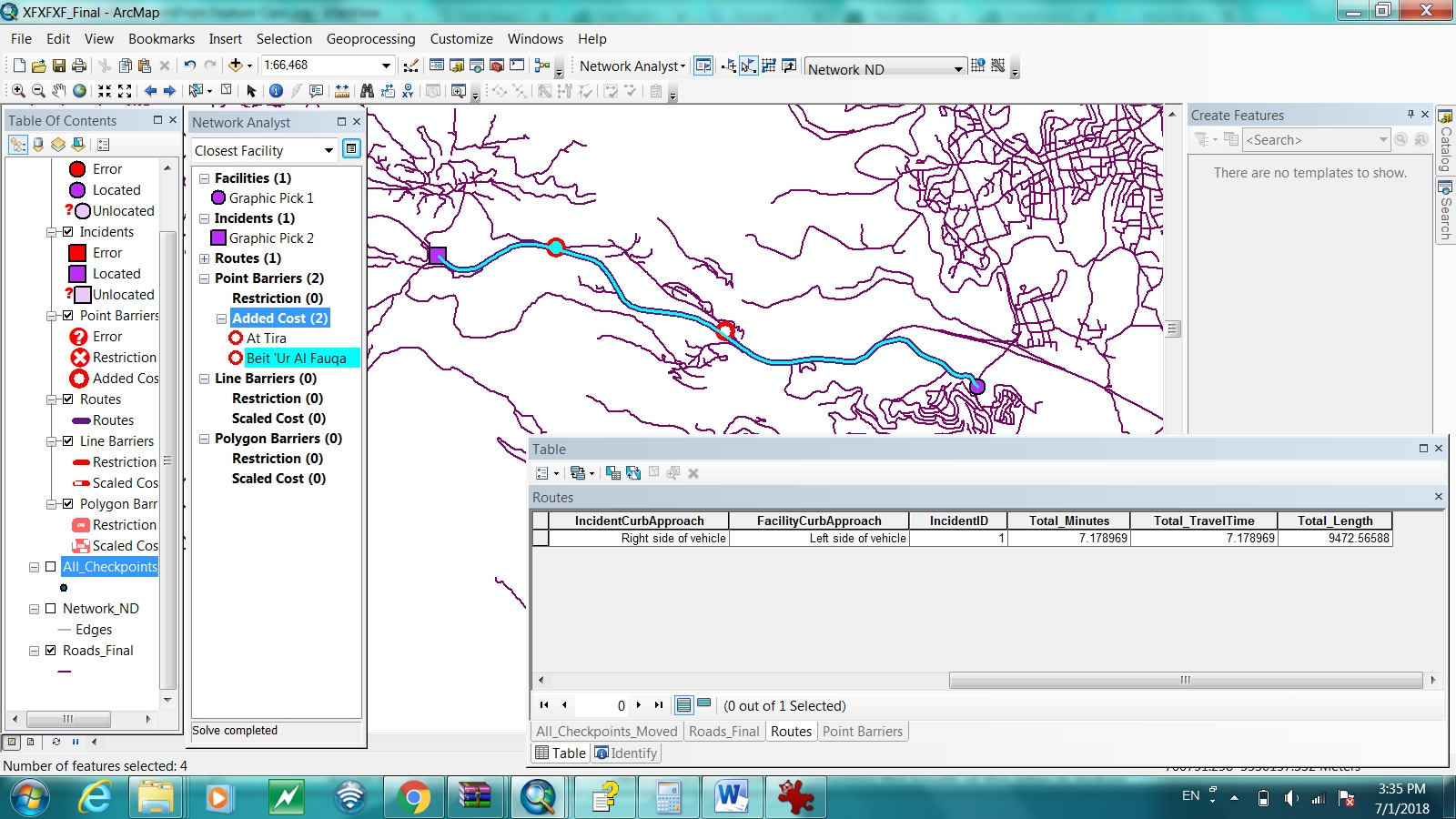
Result Route using Feature Class Checkpoint , not adding the delay time, Total minutes and Total Travel time the same
- Mark as New
- Bookmark
- Subscribe
- Mute
- Subscribe to RSS Feed
- Permalink
- Report Inappropriate Content
Faud,
From your second screen shot showing the Analysis Setting, you are using Minutes as the Impedance attribute. SO in that case, you have to be using Attr_Minutes for the delay. Each impedance attribute that is in the network dataset has a corresponding Attr_<impedance_name>. Only one will be used. So if you are solving on minimizing "Minutes", then make sure to have the delay values in the Attr_Minutes and load that when you load the locations.
You can accumulate any or all of the impedance attributes, but only the one you solved on will have the additional delays accumulated as they were taken into account when solving.
I hope that this will clear up the issue you are having. Let me know.
Jay Sandhu
- Mark as New
- Bookmark
- Subscribe
- Mute
- Subscribe to RSS Feed
- Permalink
- Report Inappropriate Content
Dear Jay
Thanks again for your response , your comments are truly right but my problem its something else , I noticed that I have an error in the Network Data set, I got that error during the building process but i ignored it, the error is " Build Errors in network dataset "SourceName: All Checkpoints Moved, ObjectID: 50, Standalone user-defined junction is detected." this error is listed for all the checkpoints layer , I searched the internet for a way to fix this error , I found this answer : arcgis 10.0 - How to connect stops to road for network dataset? - Geographic Information Systems Sta...
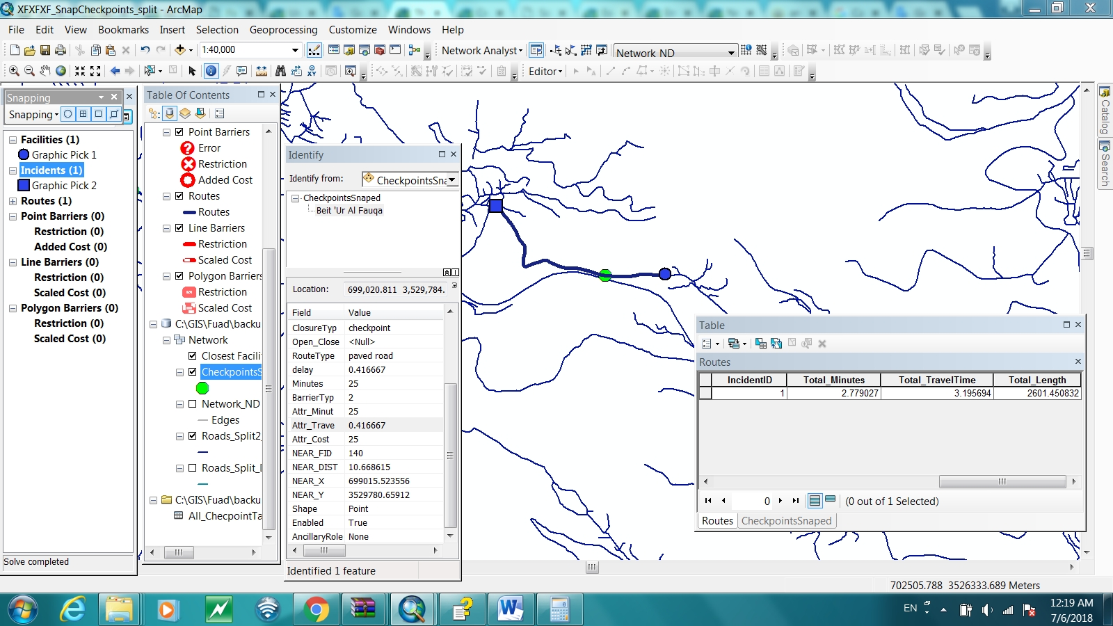
I followed the instructions , snapped my checkpoints to Road System, I used the "Split Line at Point" tool to split my roads , the Integrate tool didn't work for me ,i got some errors when i run it , finally i built the Network data set again ,
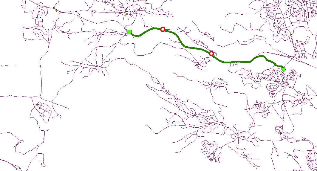
it works fine but the problem is that the checkpoints are part of the Network , I am not using the Barriers attributes in the Network Analyst box so when i need to use different set of years for the checkpoints I have to rebuild the network again for each year , this way is not convenient , see Attached
any help will be appreciated
Thanks
- Mark as New
- Bookmark
- Subscribe
- Mute
- Subscribe to RSS Feed
- Permalink
- Report Inappropriate Content
Faud,
I am no longer sure what is the problem you are trying to solve.
In the end you say "this way is not convenient". Is that the problem?
I think what you need to state is what is that you are trying to do. For example, what role do the check points play? If they are not on the network and you have to manually snap/split the lines, etc., SHOULD they even have been made part of the network dataset? Could they have been loaded into a route analysis layer as barriers?
So not sure what you need help on.
Jay Sandhu