- Home
- :
- All Communities
- :
- Products
- :
- ArcGIS Pro
- :
- ArcGIS Pro Questions
- :
- Tool failed: Error 999999 when running unsupervise...
- Subscribe to RSS Feed
- Mark Topic as New
- Mark Topic as Read
- Float this Topic for Current User
- Bookmark
- Subscribe
- Mute
- Printer Friendly Page
Tool failed: Error 999999 when running unsupervised classification
- Mark as New
- Bookmark
- Subscribe
- Mute
- Subscribe to RSS Feed
- Permalink
- Report Inappropriate Content
I am trying to run the image classification tool but every time I run it I get this non-descriptive general error that does not help identify the issue: Error 999999 Failed to Execute TrainIsoClusterClassifier. I've tried running it through the classification wizard and through the toolbox, neither work. Does anybody have a way to get this tool to actually work? I am trying to classify some Landsat 8 imagery, I have tried with default values, and changing values with no luck..
What is the secret to get this to work?
- Mark as New
- Bookmark
- Subscribe
- Mute
- Subscribe to RSS Feed
- Permalink
- Report Inappropriate Content
where does the data reside?
projected ?unprojected?
are there spaces in the paths and/or are the paths to the data convoluted.
how big is the file?
what are your resources? and does you computer exceed the recommended specs?
can you show the inputs from the dialog?
Anything would help.
The devil always is in the details…. which are always in the help topic
- Mark as New
- Bookmark
- Subscribe
- Mute
- Subscribe to RSS Feed
- Permalink
- Report Inappropriate Content
Data resides on the E: drive, tried copying it over to the 😧 drive no difference. I have also tried copying it within the project database.
Imagery is projected
No spaces and it is in a rather direct location (also tried copying it over directly to E:/)
Each image is 118MB with the exception of the panchromatic band at 474MB, when I create the composite of bands 1-7 it is 814MB
As for resources my computer specs exceeds all recommended specs
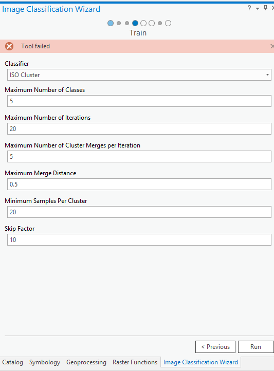
I have attached out inputs and error message.
For some strange reason the classification works when I used the panchromatic band (Landsat 8 - Band 8), but not with other bands, or the composite image.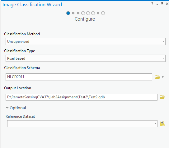

- Mark as New
- Bookmark
- Subscribe
- Mute
- Subscribe to RSS Feed
- Permalink
- Report Inappropriate Content
hmmm pretty big for a lab assignment 
I will share with Imagery and Remote Sensing maybe someone there can peak in on this
- Mark as New
- Bookmark
- Subscribe
- Mute
- Subscribe to RSS Feed
- Permalink
- Report Inappropriate Content
from the help, can you confirm the source the image type first?
Any Esri-supported raster is accepted as input, including raster products, segmented raster, mosaics, image services, or generic raster datasets. Segmented rasters must be 8-bit rasters with 3-bands.
- Mark as New
- Bookmark
- Subscribe
- Mute
- Subscribe to RSS Feed
- Permalink
- Report Inappropriate Content
The raster images are 16-bit unsigned integer which are supported from what I have read in the help menu. It is a Landsat 8 OLI/TIRS C1 Level 1 data product (GeoTIFF format) downloaded directly from USGS Earth Explorer.
I'm not sure why the panchromatic band can be classified but no other bands. The only difference is pixel size is 15m v 30m for the other bands I am using.
Steve
- Mark as New
- Bookmark
- Subscribe
- Mute
- Subscribe to RSS Feed
- Permalink
- Report Inappropriate Content
Hi Steve,
Does the tool run successfully if you use the RGBI bands ?
- Mark as New
- Bookmark
- Subscribe
- Mute
- Subscribe to RSS Feed
- Permalink
- Report Inappropriate Content
No luck, I tried each band individually and I created a RBGI composite using 'Composite Bands' tool. They did not work.
Steve
- Mark as New
- Bookmark
- Subscribe
- Mute
- Subscribe to RSS Feed
- Permalink
- Report Inappropriate Content
OK, good news, managed to get it to work so I thought I would provide an update. I managed to get it working by downloading a different Landsat 8 data product from Earth Explorer Landsat 8 - C1 Level 2 data product (which is Landsat 8 processed into surface reflectance).. I classified both a RGBI composite and individual bands.
I'm still not sure why the original product I downloaded did not work as all satellite imagery is inherently surface reflectance.. Must not have liked the values.
So if you want to classify Landsat 8 data, make sure to download the Level-2 product!
Thanks, for your help, Sangeet and Dan.
- Mark as New
- Bookmark
- Subscribe
- Mute
- Subscribe to RSS Feed
- Permalink
- Report Inappropriate Content
apparently fixed
Release notes for ArcGIS Pro 2.2—ArcGIS Pro | ArcGIS Desktop
BUG-000115473 | Image Classification: The TrainISOCluster tool fails when training on Landsat 8 Level 1 data. |