- Home
- :
- All Communities
- :
- Products
- :
- ArcGIS Online
- :
- ArcGIS Online Questions
- :
- ArcGIS Online display of wind barbs?
- Subscribe to RSS Feed
- Mark Topic as New
- Mark Topic as Read
- Float this Topic for Current User
- Bookmark
- Subscribe
- Mute
- Printer Friendly Page
- Mark as New
- Bookmark
- Subscribe
- Mute
- Subscribe to RSS Feed
- Permalink
- Report Inappropriate Content
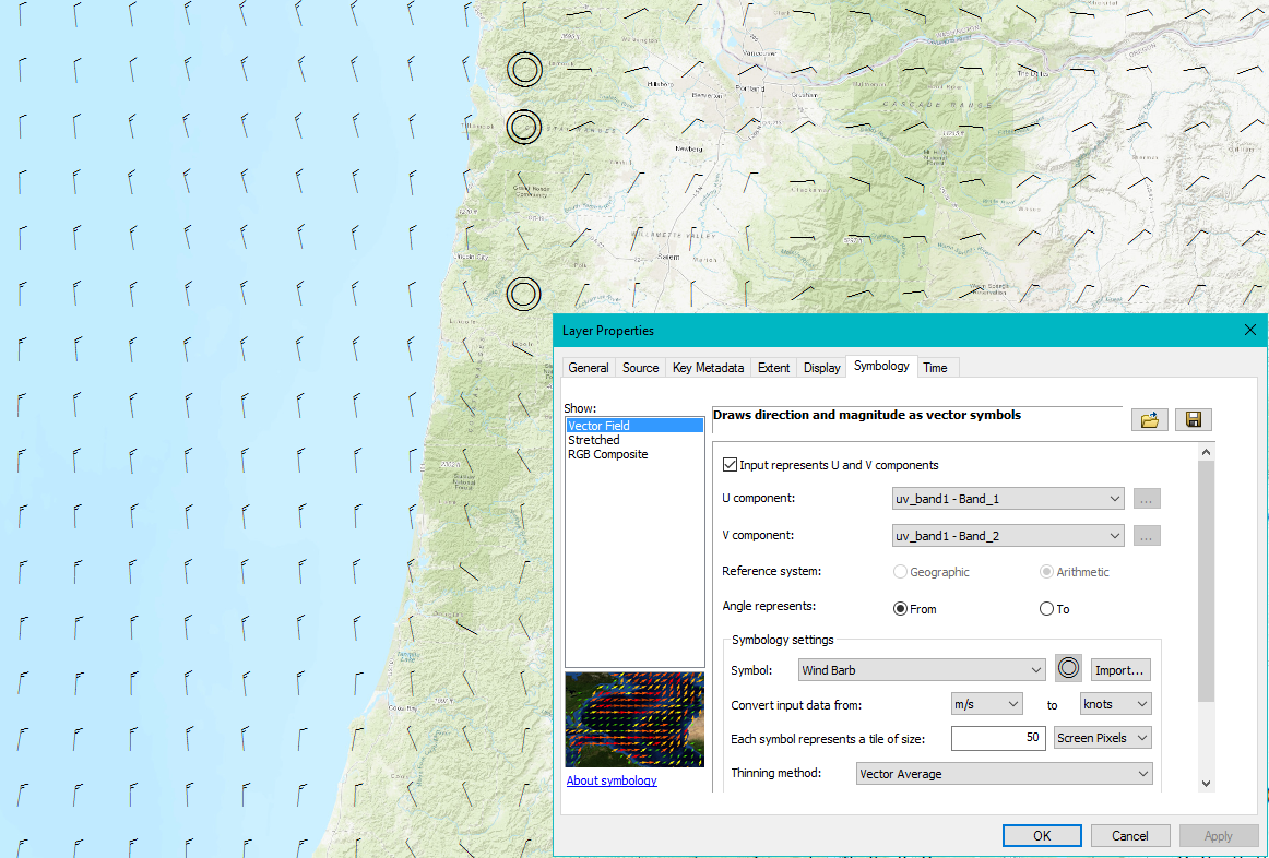
I have been using the "Vector Field" option for displaying wind barbs from raster data representing the U,V components of wind speed. I'm pretty happy with that in Pro or ArcMap, since it works with the data I have, so I don't have to convert it to vector data. Here is the methodology I'm using.
Drawing raster data using vector symbols—Help | ArcGIS for Desktop
I was wondering if anyone has had any luck doing something like this in ArcGIS Online?
Solved! Go to Solution.
Accepted Solutions
- Mark as New
- Bookmark
- Subscribe
- Mute
- Subscribe to RSS Feed
- Permalink
- Report Inappropriate Content
Hello David,
I'd recommend considering use of a rotation-by-value functionality with an arrow symbol.
This blog breaks down this ArcGIS Online capability rather nicely and provides sample data:
Rotating point symbols in web maps
Hopefully that gets you what you're looking for!
ArcGIS Online Technology Lead
Esri Support Services
- Mark as New
- Bookmark
- Subscribe
- Mute
- Subscribe to RSS Feed
- Permalink
- Report Inappropriate Content
Hi Rachel, Thanks for the link. My question was asking if the symbology options for raster data wind barbs in ArcMap/Pro also exist in AGOL. They are really handy since my data are already in raster format and they also resample the data nicely at multiple scales. I suspect that I will end up creating point layers at a few scales and displaying them using this methodology in order to publish to AGOL.
- Mark as New
- Bookmark
- Subscribe
- Mute
- Subscribe to RSS Feed
- Permalink
- Report Inappropriate Content
This is an old thread, but in case anyone comes across it, you can visualize vector field rasters this way in the new Map Viewer and 4.x-based apps, along with Beaufort scale arrows and the flow renderer.