- Home
- :
- All Communities
- :
- Products
- :
- ArcGIS Pro
- :
- ArcGIS Pro Questions
- :
- Error 00230 when sharing map as a WebMap
- Subscribe to RSS Feed
- Mark Topic as New
- Mark Topic as Read
- Float this Topic for Current User
- Bookmark
- Subscribe
- Mute
- Printer Friendly Page
Error 00230 when sharing map as a WebMap
- Mark as New
- Bookmark
- Subscribe
- Mute
- Subscribe to RSS Feed
- Permalink
- Report Inappropriate Content
Hello,
I'm trying to share a simple map from ArcGIS Pro that contains polygons drawn onto world imagery. Both layers use the matching coordinate system "WGS 1984 Web Mercator Auxiliary Sphere" after I reprojected my polygon layer to match.
However I continue to get the error: "Service layer has a different projection than the map's projections - 00230"
I don't understand why this error is persisting after I matched the coordinated systems.
Any help will be appreciated!
- Mark as New
- Bookmark
- Subscribe
- Mute
- Subscribe to RSS Feed
- Permalink
- Report Inappropriate Content
00230: Service layer has a different projection than the 's projection—ArcGIS Pro | ArcGIS Desktop
gives some explanation. Can you review your procedure in light of this, remembering 'Define Projection' is only used if a layer doesn't have a coordinate system defined. 'Project' physically makes a new file with the desired coordinate system
- Mark as New
- Bookmark
- Subscribe
- Mute
- Subscribe to RSS Feed
- Permalink
- Report Inappropriate Content
Hi Dan,
Yes, I have already reviewed that resource. I believe that I "reprojected" the layers, using a .prj file, to make sure that they are matching. In "Properties -> Coordinate Systems" for the map, both my polygon and world imagery layers are listed as the same.
The coordinate systems appear to be objectively matching? Is this not the correct way to see what the coordinate systems are?
- Mark as New
- Bookmark
- Subscribe
- Mute
- Subscribe to RSS Feed
- Permalink
- Report Inappropriate Content
not really... you examine their 'extents' to ensure they make sense.
I can define ANY featureclass etc as anything I want... it doesn't make it so.
IF a *.prj file existed with the data, there is the reasonable chance that it was defined correctly.
If you applied a *.prj to another file, it doesn't 'project it'... that is only done with the Project tool in arctoolbox.
So, examine your extents.... Long/Lat is in the range -180 to 180 and 90 to -90. That would be a GCS... a geographic coordinate system. big numbers are your first clue that something is 'projected'... the only question is whether its projection is correct
- Mark as New
- Bookmark
- Subscribe
- Mute
- Subscribe to RSS Feed
- Permalink
- Report Inappropriate Content
I created the *.prj file by saving the coordinate system of my world imaging and using the"Project" arcpy tool. 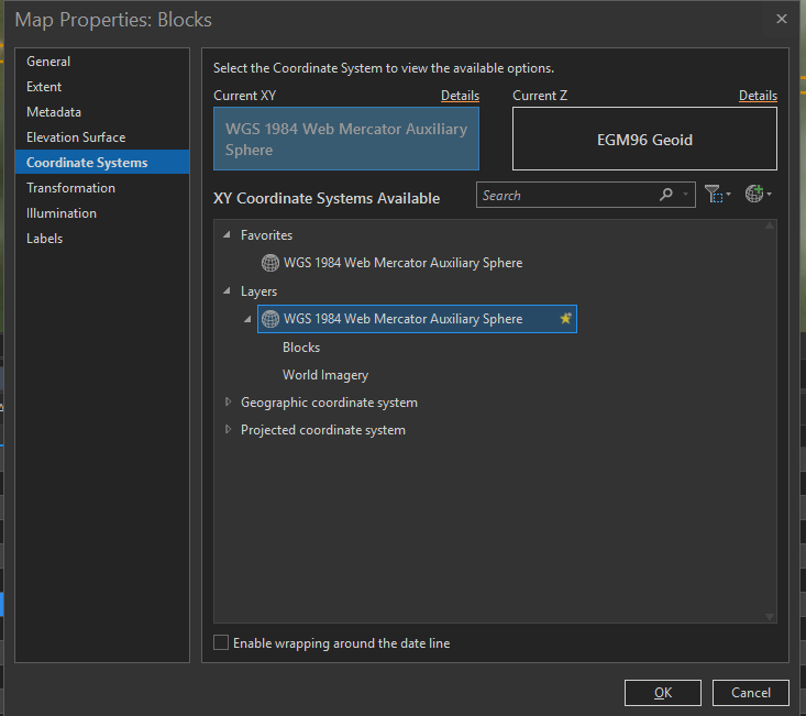
Above is a picture of the properties of my map. You're saying that while the coordinate systems agree in the window, that might not be true?
- Mark as New
- Bookmark
- Subscribe
- Mute
- Subscribe to RSS Feed
- Permalink
- Report Inappropriate Content
….polygons drawn onto world imagery....
What is the coordinate system of the polygons you drew and what is the world imagery coordinate system?
Do they match?
If they are in a GCS WGS84, then you can Project them to World Mercator.
Somewhere along the line you have to specify a coordinate system for the polygons.. either the map frame or the basemap (which may be the same) or something else.
'Extent'.. That is what I would like to see... the left, right, top and bottom of the featureclasses
- Mark as New
- Bookmark
- Subscribe
- Mute
- Subscribe to RSS Feed
- Permalink
- Report Inappropriate Content
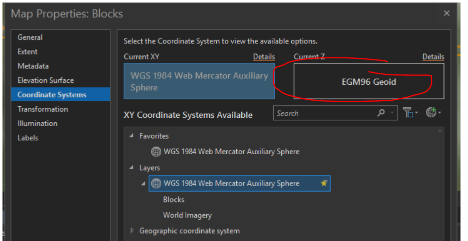
Maybe something to do with z? This isn't default:
- Mark as New
- Bookmark
- Subscribe
- Mute
- Subscribe to RSS Feed
- Permalink
- Report Inappropriate Content
Thanks for your help Dan and Kory,
After some monkeying around with the webmap publishing function it seems to be working (with the settings in the picture I linked). I'm not sure what exactly I did but as far as I can tell after I successfully published a different, non-related webmap the original map in question was able to upload (no settings changed). The Z coord system isn't causing any problems, as Kory suggested was possible.
To match the coordinate systems between the "World Imagery" layer and the "Blocks" I used code demonstrated here: