- Home
- :
- All Communities
- :
- Products
- :
- ArcGIS Pro
- :
- ArcGIS Pro Questions
- :
- Dubious Geoprocessed 3D layer behaviors
- Subscribe to RSS Feed
- Mark Topic as New
- Mark Topic as Read
- Float this Topic for Current User
- Bookmark
- Subscribe
- Mute
- Printer Friendly Page
Dubious Geoprocessed 3D layer behaviors
- Mark as New
- Bookmark
- Subscribe
- Mute
- Subscribe to RSS Feed
- Permalink
- Report Inappropriate Content
I’m trying to animate a linear path. I start w/ a datafile of 8000 lat/lon/elev points.
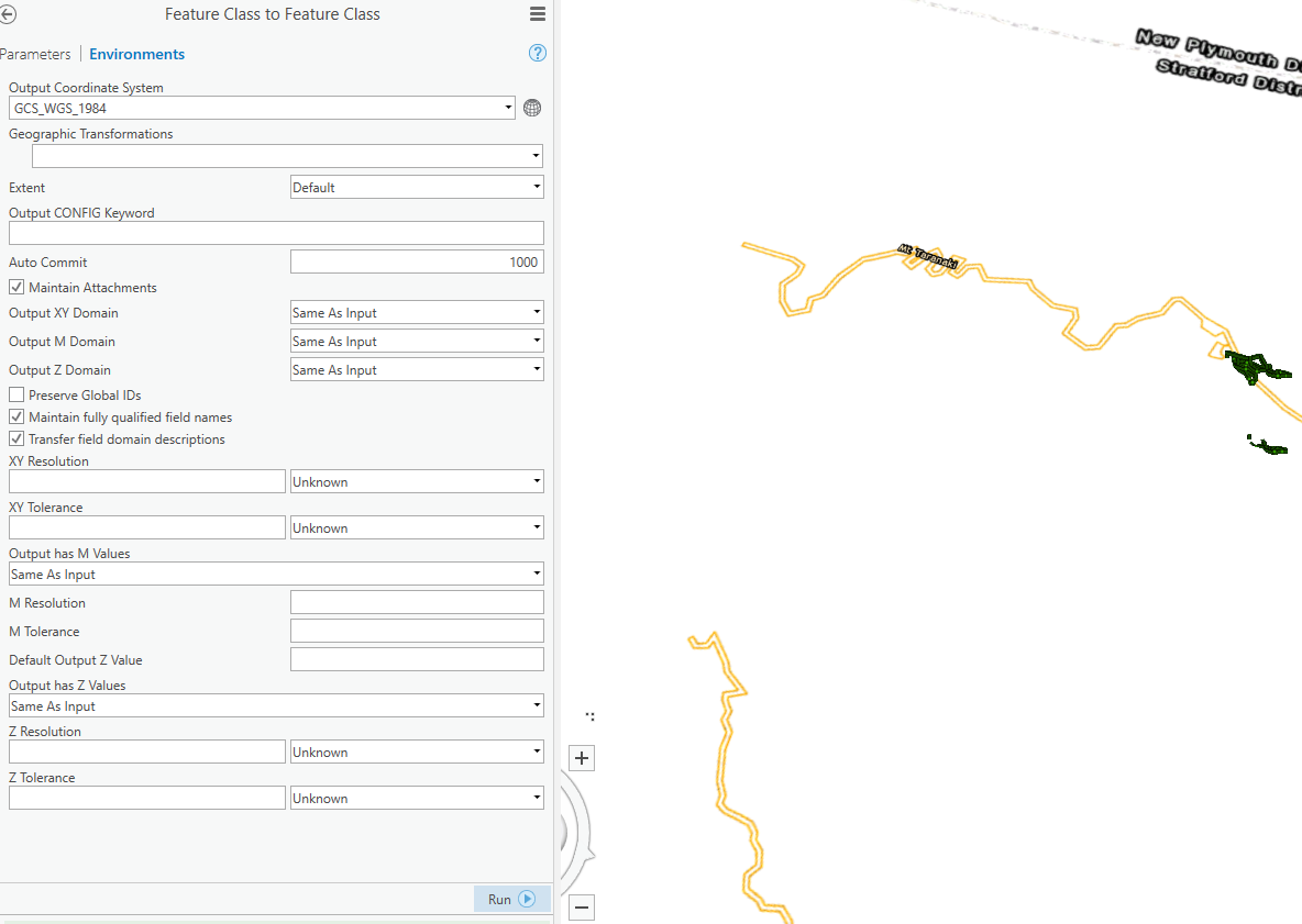
From the tutorial, I learned to apply the following geoprocesses:
- Make XY event layer
- Feature class to Feature Class
- Points to Line
- Split line at Vertices
I don’t have any problems doing any of this in 2D. All of the geoprocessed output layers work and I can continue w/ animating the final geoprocessed (Split line at Vertices) layer. So I’ve proven sufficient competency in 2D.
But in 3D, everything goes awry. For 3D data I am using the project data from the 3D basic tutorial “Create Points on a Map” http://pro.arcgis.com/en/pro-app/get-started/create-points-on-a-map.htm
After applying a geoprocess (eg. Feature to feature, points to line, split line at vertices) the resultant layer should match exactly (and thus sit on top of) the input layer. Correct?
But many if not all the resultant output layers do not match. Many of the resultant output layers (when they’re visible, often they’re not… ☹ ) do not match the position of their input layer and thus are translated (seemingly randomly) some meters up/down/right/left (albeit the shape is retained).
I’ve exported & examined the shape file data to no avail.
I’ve deleted/updated/etc. cache settings, and project spatial index settings all to no avail.
I’ve played w/ visibility ranges.
In fact changing layer properties seems to have no positive affect nor yield any illumination on the problem.
Are these ArcGIS Pro bugs? If yes, what can I do? If no please tell me what I’m missing. At this point I have no faith in my ability to geoprocess or otherwise control my ArcGIS Pro layers. Thank you in advance for any help or advice (including anything I’ve tried before).
Background info:
Using ArcGIS Pro 2.1.3 (auto update on).
I got my info on how to do this from this quick useful demo: https://www.youtube.com/watch?v=tq4rzFPXwr4 (please note my problem/questions are not about animation per se. My problem is with the behavior/visibility of the resultant 3D geoprocessed output layers.
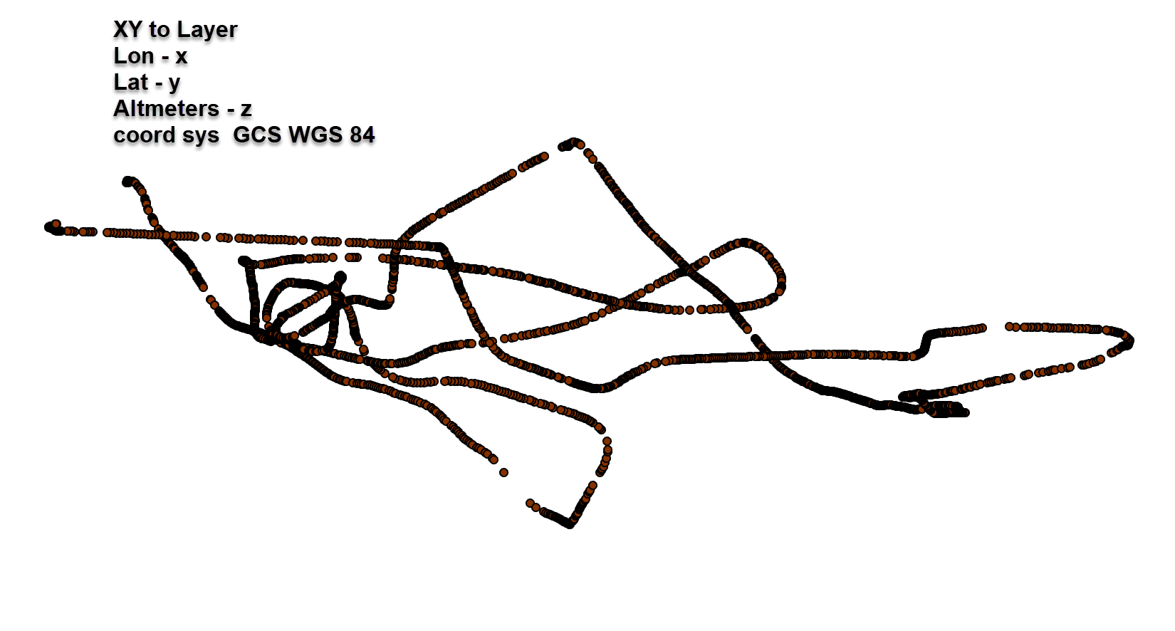
My data represents a single drone trajectory flight path with 8000 lat/lon/elev points in GCS WGS 1984.
Screenshot 1) Why are the layers shifted? No coordinate translation should have occurred in the above mentioned geoprocesses. One layer should be sitting on top of the other.
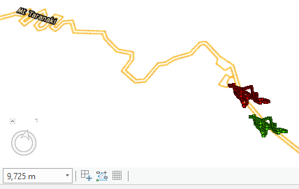
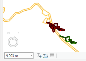
Screenshot 2) Zoom in 700m and the green layer starts to disintegrate and the red is stable. Why? Why don't both layers behave the same?
- Mark as New
- Bookmark
- Subscribe
- Mute
- Subscribe to RSS Feed
- Permalink
- Report Inappropriate Content
during the process from Longitude/latitude to featureclass, whas the data defined as a GCS WGS84 ie a geographic coordinate system. Undefined data can behave strangely especially if you are working with web-based web Mercator data.
- Mark as New
- Bookmark
- Subscribe
- Mute
- Subscribe to RSS Feed
- Permalink
- Report Inappropriate Content
Dan,
I've double checked that. The CS is the same for the input & the output = GCS_WGS_1984.
After cleaning up & re-running several times the dubious behavior is still very evident:
- output layer is shifted to the south.
- it disintegrates when zooming in
- reintegrates when zooming out.
- Mark as New
- Bookmark
- Subscribe
- Mute
- Subscribe to RSS Feed
- Permalink
- Report Inappropriate Content
You might have to show your csv with the coordinates.
recently coordinates that were converted from Degrees Decimal minutes incorrectly caused a shift... so I am leary of anything shifty these days
- Mark as New
- Bookmark
- Subscribe
- Mute
- Subscribe to RSS Feed
- Permalink
- Report Inappropriate Content
Sample of data:
| Lon | Lat | Altmeters |
| 174.123329 | -39.3064874 | 39.59999847 |
| 174.1233295 | -39.30648706 | 39.70000076 |
| 174.1233297 | -39.30648681 | 39.70000076 |
| 174.1233294 | -39.30648647 | 39.79999924 |
| 174.1233292 | -39.30648642 | 39.79999924 |
| 174.1233287 | -39.30648645 | 39.90000153 |
| 174.1233284 | -39.30648645 | 39.90000153 |
| 174.1233282 | -39.30648648 | 39.90000153 |
| 174.123328 | -39.30648641 | 39.90000153 |
| 174.1233278 | -39.30648647 | 39.90000153 |
| 174.1233276 | -39.30648656 | 39.90000153 |
| 174.1233274 | -39.30648662 | 39.90000153 |
| 174.1233273 | -39.30648658 | 39.90000153 |
| 174.1233272 | -39.30648663 | 40 |
| 174.123327 | -39.30648667 | 40 |
| 174.1233269 | -39.30648671 | 40 |
| 174.1233267 | -39.30648665 | 40 |
| 174.1233267 | -39.30648665 | 40 |
| 174.1233265 | -39.3064867 | 40 |
| 174.1233266 | -39.30648675 | 40 |
| 174.1233266 | -39.30648717 | 40 |
| 174.1233267 | -39.3064874 | 40 |
| 174.1233268 | -39.30648759 | 40 |
| 174.1233268 | -39.30648784 | 40 |
| 174.123327 | -39.30648796 | 40 |
| 174.1233271 | -39.30648797 | 39.90000153 |
- Mark as New
- Bookmark
- Subscribe
- Mute
- Subscribe to RSS Feed
- Permalink
- Report Inappropriate Content
John when you made that map, a base layer was added first is my guess.
Assuming you defined the coordinate system correctly (seems like an ok assumption), did you try adding the data to a new Map without!!! a default basemap... nothing... just the data and define the Map's coordinate system appropriately. I just want to rule out some projection-on-the-fly issue. Add your other 2d point data next and see if it aligns properly after... then the 3d line
- Mark as New
- Bookmark
- Subscribe
- Mute
- Subscribe to RSS Feed
- Permalink
- Report Inappropriate Content
Thank you.
The above is a big bite for this Noob. Please give me time to grasp/investigate.
- Mark as New
- Bookmark
- Subscribe
- Mute
- Subscribe to RSS Feed
- Permalink
- Report Inappropriate Content
Link to the datafile (it is ~4000 points and not 8000 as originally stated): https://drive.google.com/file/d/1q7MhjVh81a522EEc-J4xmdRmSbWXlCfq/view?usp=sharing
- Mark as New
- Bookmark
- Subscribe
- Mute
- Subscribe to RSS Feed
- Permalink
- Report Inappropriate Content
John... downloaded and before I go further..
process and result setting Map to the same GCS
Does this look OK?
- Mark as New
- Bookmark
- Subscribe
- Mute
- Subscribe to RSS Feed
- Permalink
- Report Inappropriate Content
YES.