- Home
- :
- All Communities
- :
- Products
- :
- Data Management
- :
- Data Management Questions
- :
- NAD1983 (2011) to WGS 1984 Web Mercator
- Subscribe to RSS Feed
- Mark Topic as New
- Mark Topic as Read
- Float this Topic for Current User
- Bookmark
- Subscribe
- Mute
- Printer Friendly Page
- Mark as New
- Bookmark
- Subscribe
- Mute
- Subscribe to RSS Feed
- Permalink
- Report Inappropriate Content
Hello,
I noticed building footprints in Web Mercator Auxiliary Sphere projection were off by roughly 3 inches when draped on ESRI basemaps. However, when I publish the building footprints from the native coordinate system (NAD1983_2011 NY State Plane) it successfully projects on the fly and the footprints sit nicely on ESRI basemaps. I'd really like to continue using my datasets dedicated to web maps (Web Mercator Aux) and correct the shift occurring with this data.
When I take my data from my parent dataset(s) in NY State Plane to the child in Web Mercator Aux I am getting a transformation that isn't complete. I just wanted to throw this out to the community and see if anyone had a suggestions for me.
Take Care,
John Brockwell
Solved! Go to Solution.
Accepted Solutions
- Mark as New
- Bookmark
- Subscribe
- Mute
- Subscribe to RSS Feed
- Permalink
- Report Inappropriate Content
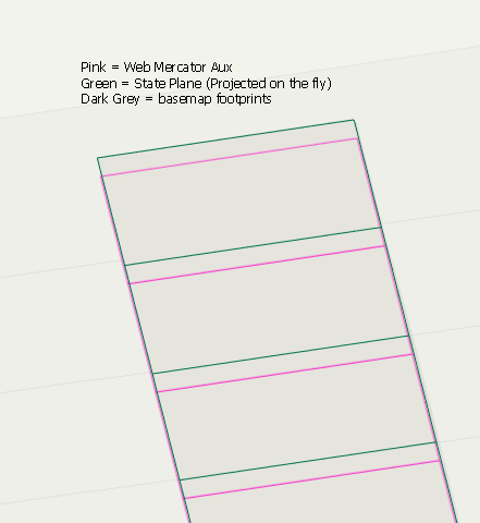
It needed a geographic transformation from NAD 83 (State Plane) to WGS 1984 (Web Mercator Aux) included. It is added as part of environments with the project tool. In my instance it was WGS_1984_(ITRF08)_To_NAD_1983_2011.
I also created a file geodatabase to convert the data and then I copied and pasted back into the enterprise geodatabase. Not sure why I coudn't do it directly within my enterprise geodatabases but I have found it is better to work around these types of snags versus finding the answer.
Take Care,
JB
- Mark as New
- Bookmark
- Subscribe
- Mute
- Subscribe to RSS Feed
- Permalink
- Report Inappropriate Content
Melita Kennedy flagging you.
Not sure this is due to coordinate systems or just the limitations of web Mercator and basemaps given the differences
- Mark as New
- Bookmark
- Subscribe
- Mute
- Subscribe to RSS Feed
- Permalink
- Report Inappropriate Content
John,
When you say "building footprints in Web Mercator Auxiliary Sphere projection were off by roughly 3 inches", are you talking about your own footprints in desktop GIS using an Esri basemap?
Can you post screenshots of what you're seeing and from what media you are seeing it from (AGOL, desktop, etc.)?
- Mark as New
- Bookmark
- Subscribe
- Mute
- Subscribe to RSS Feed
- Permalink
- Report Inappropriate Content
Hi,
Yes, I am referring to my own building footprints in the same coordinate system as the basemaps (Web Mercator Aux). My State Plane building footprints project on the fly and appear correct. I want to store them in the proper coordinate system and eliminate projecting on the fly.
I have two enterprise geodatabases. One is for day to day business uses (State Plane NAD 1983). The second is for publishing maps, apps, and mobile data collection (Web Mercator Aux WGS 1984).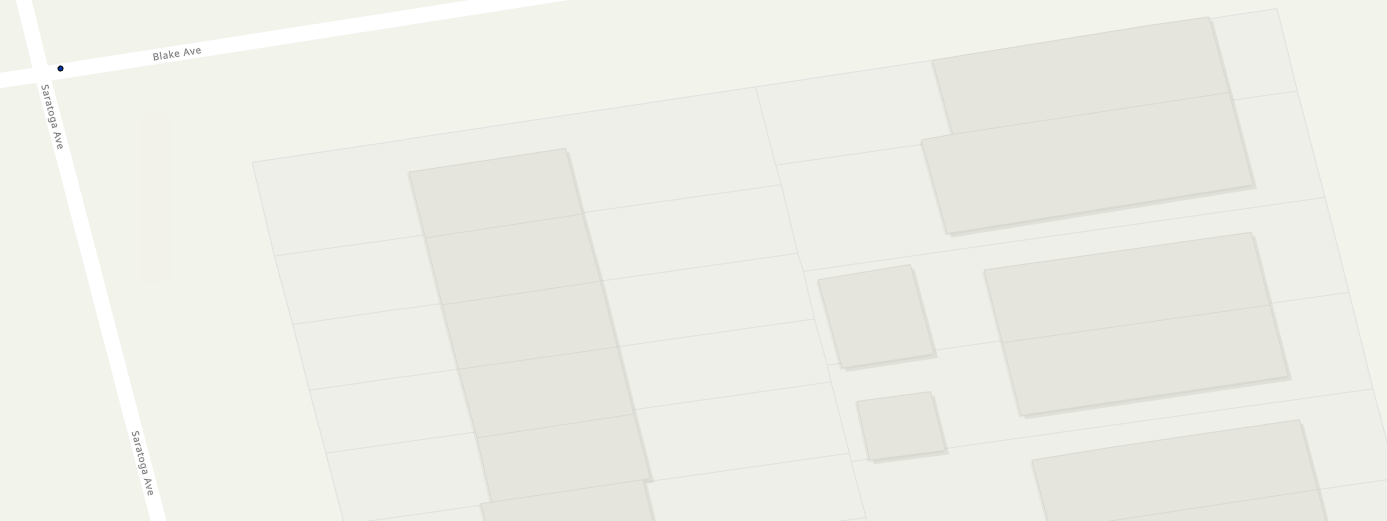
- Mark as New
- Bookmark
- Subscribe
- Mute
- Subscribe to RSS Feed
- Permalink
- Report Inappropriate Content
It needed a geographic transformation from NAD 83 (State Plane) to WGS 1984 (Web Mercator Aux) included. It is added as part of environments with the project tool. In my instance it was WGS_1984_(ITRF08)_To_NAD_1983_2011.
I also created a file geodatabase to convert the data and then I copied and pasted back into the enterprise geodatabase. Not sure why I coudn't do it directly within my enterprise geodatabases but I have found it is better to work around these types of snags versus finding the answer.
Take Care,
JB