- Home
- :
- All Communities
- :
- Products
- :
- ArcGIS Spatial Analyst
- :
- ArcGIS Spatial Analyst Questions
- :
- Georeferencing issues
- Subscribe to RSS Feed
- Mark Topic as New
- Mark Topic as Read
- Float this Topic for Current User
- Bookmark
- Subscribe
- Mute
- Printer Friendly Page
Georeferencing issues
- Mark as New
- Bookmark
- Subscribe
- Mute
- Subscribe to RSS Feed
- Permalink
- Report Inappropriate Content
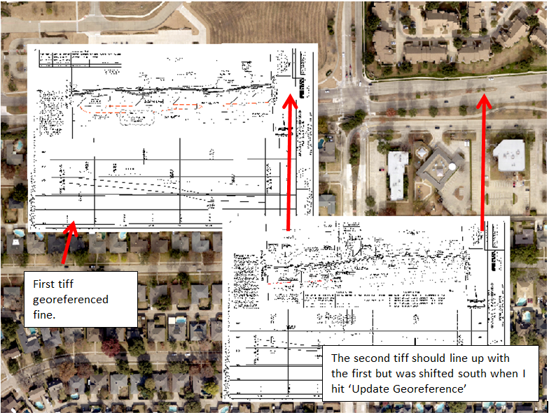
Hello,
I recently upgraded to 10.5 from 10.2.1. Everything was going fine until I tried to georeference. Everything would be fine until I hit 'Update Georeference' at which point the tiff would move to a different location. Usually it would just be scooted down, but every now and then it would be moved off into no man's land. I researched trying to find out what the issue might be but couldn't come up with anything.
This morning I upgraded to 10.6 hoping that maybe it was just a weird quirk in 10.5 but the same thing happened in 10.6. I was able to georeference one tiff just fine, but the second one was shifted south as soon as I hit 'Update Georeferencing'. Has anyone experienced this and know how to fix it? Georeferencing is a large part of my job and I really need this issue fixed.
Some notes:
-My coworker is experiencing the same thing so it shouldn't be something with my computer.
-My georeferecning workflow consists of turning a PDF into separate tiffs and then bringing those tiffs into ArcMap.
- Mark as New
- Bookmark
- Subscribe
- Mute
- Subscribe to RSS Feed
- Permalink
- Report Inappropriate Content
Are you georeferencing with keyboard (lat/lon values) or aligning the raster with control points using a referenced image?
What spatial reference are you using?
In case you are georeferencing using lat/lon values, could you let us know the values Xmin, Ymin, Xmax and Ymax for the image that is shifting incorrectly?
Think Location
- Mark as New
- Bookmark
- Subscribe
- Mute
- Subscribe to RSS Feed
- Permalink
- Report Inappropriate Content
I am using control points to align the tiff on our already in place aerials.
By spatial reference do you mean coordinate system? NAD 1983 StatePlane Texas North Central FIPS 4202 Feet
- Mark as New
- Bookmark
- Subscribe
- Mute
- Subscribe to RSS Feed
- Permalink
- Report Inappropriate Content
Is there the slimmest of chances that the data frame and the featureclass you are georeferencing to are not in the exact same coordinate system? a shift south suggests a datum difference
- Mark as New
- Bookmark
- Subscribe
- Mute
- Subscribe to RSS Feed
- Permalink
- Report Inappropriate Content
From what I can tell, everything has the same coordinate system. I've checked the dataframe, the aerials I am referencing to, and the tiff. All of them say they are in the 4202 State Plane system.
- Mark as New
- Bookmark
- Subscribe
- Mute
- Subscribe to RSS Feed
- Permalink
- Report Inappropriate Content
it doesn't appear to be a feet vs meters issue... it was the datum that I was interested in (nad 27 vs nad 83)
- Mark as New
- Bookmark
- Subscribe
- Mute
- Subscribe to RSS Feed
- Permalink
- Report Inappropriate Content
My group has been experiencing the same issue and can't seem to figure it out. We recently upgraded from 10.5.1 to 10.6.1 hoping that the issue was resolved, but it hasn't changed. So far the only work around we've found is to use JPGs instead of TIFFs, which is not always ideal for certain workflows.
- Mark as New
- Bookmark
- Subscribe
- Mute
- Subscribe to RSS Feed
- Permalink
- Report Inappropriate Content
That's exactly the work around that I started using. JPGs seem to have no issue.
- Mark as New
- Bookmark
- Subscribe
- Mute
- Subscribe to RSS Feed
- Permalink
- Report Inappropriate Content
I also have this problem that appeared when we upgraded from ArcMap 10.3 to 10.6. I too am trying to georeference .tiffs derived from .pdf. The georeference seems to shift to the south or southwest hundreds of feet when I hit the 'update georeferencing' button. I too have thought about the coordinate system but see no issue. I have deleted the Normal.mxt and recovered normal operation for one or two georeferences before it reverts back to the undesirable behavior. Fortunately, the shift so far is linear: meaning I can drag the image back to where it belongs and 'update georeferencing' again, and it sticks. Others might try ArcPro, which might save the georeferencing and translate back to ArcMap. I did not try a .jpeg.
- Mark as New
- Bookmark
- Subscribe
- Mute
- Subscribe to RSS Feed
- Permalink
- Report Inappropriate Content
Has anyone come up with a solution for the TIFF files shifting location when 'Update Georeferencing' is clicked? We are using ArcGIS 10.7.1 and Pro 2.6 and is happening on both products. I have several hundred TIFF files scanned back in 2017 that lost their georeferencing after a server migration. This issue happens about 50% of the time and it is very frustrating.
Thank you.
Julio G