- Home
- :
- All Communities
- :
- Products
- :
- ArcGIS Online
- :
- ArcGIS Online Questions
- :
- How do I clip a layer exactly to the boundaries of...
- Subscribe to RSS Feed
- Mark Topic as New
- Mark Topic as Read
- Float this Topic for Current User
- Bookmark
- Subscribe
- Mute
- Printer Friendly Page
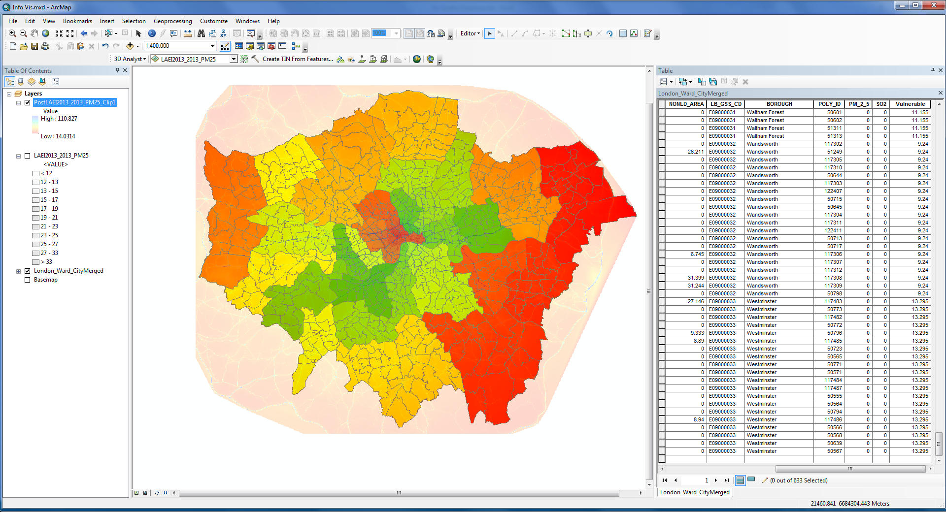
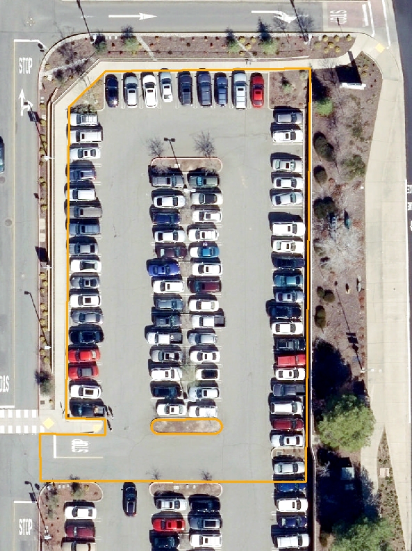
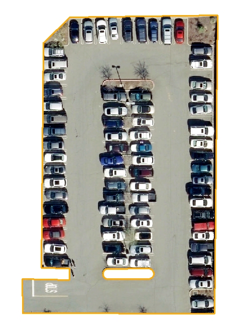
How do I clip a layer exactly to the boundaries of a polygon? Tried clip tool but it only cuts to an area around my polygon (Image attached)
- Mark as New
- Bookmark
- Subscribe
- Mute
- Subscribe to RSS Feed
- Permalink
- Report Inappropriate Content
Accepted Solutions
- Mark as New
- Bookmark
- Subscribe
- Mute
- Subscribe to RSS Feed
- Permalink
- Report Inappropriate Content
So If I'm understanding this correctly, you want to clip a raster (top layer) by a polygon (London Boundaries). And the software you are using is ArcGIS Desktop 10.6.
If that is the case, one workflow would be this:
1. As suggested by Xander Bakker, run the geoprocessing tool Dissolve (Data Management) on the London Boundaries to simplify it to one polygon boundary.
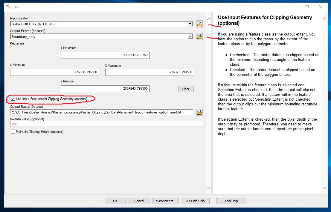
2. Run the Clip (Data Management) geoprocessing tool, specifying for "Output Extent (optional)" the feature class created from the Dissolve and checking the box to employ "Use Input Features for Clipping Geometry (optional).
Dissolve—Help | ArcGIS for Desktop
Clip—Help | ArcGIS for Desktop
Chris Donohue, GISP
- Mark as New
- Bookmark
- Subscribe
- Mute
- Subscribe to RSS Feed
- Permalink
- Report Inappropriate Content
- Mark as New
- Bookmark
- Subscribe
- Mute
- Subscribe to RSS Feed
- Permalink
- Report Inappropriate Content
If you use Clip—Help | ArcGIS Desktop on two polygon layers, it will clip the input polygons using the clip polygon (exactly). Both your layers are polygons? To avoid any redundant intersection you could dissolve the clip features (if they are multiple polygons) into a single polygon using Dissolve—Help | ArcGIS Desktop
- Mark as New
- Bookmark
- Subscribe
- Mute
- Subscribe to RSS Feed
- Permalink
- Report Inappropriate Content
Thanks for your reply, the lower layer (London boundaries) is a polygon, top layer is a raster
- Mark as New
- Bookmark
- Subscribe
- Mute
- Subscribe to RSS Feed
- Permalink
- Report Inappropriate Content
If you are trying to clip the raster by the outline of the polygons, you could also set it as Mask and do a simple Raster Calculation that returns the raster: Mask (Environment setting)—Help | ArcGIS Desktop or use Extract by Mask—Help | ArcGIS Desktop
- Mark as New
- Bookmark
- Subscribe
- Mute
- Subscribe to RSS Feed
- Permalink
- Report Inappropriate Content
So If I'm understanding this correctly, you want to clip a raster (top layer) by a polygon (London Boundaries). And the software you are using is ArcGIS Desktop 10.6.
If that is the case, one workflow would be this:
1. As suggested by Xander Bakker, run the geoprocessing tool Dissolve (Data Management) on the London Boundaries to simplify it to one polygon boundary.
2. Run the Clip (Data Management) geoprocessing tool, specifying for "Output Extent (optional)" the feature class created from the Dissolve and checking the box to employ "Use Input Features for Clipping Geometry (optional).
Dissolve—Help | ArcGIS for Desktop
Clip—Help | ArcGIS for Desktop
Chris Donohue, GISP
- Mark as New
- Bookmark
- Subscribe
- Mute
- Subscribe to RSS Feed
- Permalink
- Report Inappropriate Content
That worked perfectly, thank you for the clear explanation!
Adam
- Mark as New
- Bookmark
- Subscribe
- Mute
- Subscribe to RSS Feed
- Permalink
- Report Inappropriate Content
Its nice to see that and like a appreciated your endeavor.Keep it up to more