- Home
- :
- All Communities
- :
- Products
- :
- ArcGIS Spatial Analyst
- :
- ArcGIS Spatial Analyst Questions
- :
- IDW (SA) erroneous output when imposing barrier
- Subscribe to RSS Feed
- Mark Topic as New
- Mark Topic as Read
- Float this Topic for Current User
- Bookmark
- Subscribe
- Mute
- Printer Friendly Page
IDW (SA) erroneous output when imposing barrier
- Mark as New
- Bookmark
- Subscribe
- Mute
- Subscribe to RSS Feed
- Permalink
- Report Inappropriate Content
ArcGIS v.10.3.1 for Desktop.
I'm using the IDW (Spatial Analyst) tool to interpolate water quality data for the Island of Newfoundland. I wanted to impose a barrier to separate data collected on one side of a ocean bay from influencing results on the opposite side of the bay. The IDW tool output is wrong when imposing a barrier. For instance, the data range is incorrect (should be 0-63, not 0-13), and the input data does not correspond with the IDW output data classes. I've attached a PDF that shows the two IDW outputs: (1) no barrier imposed, and (2) barrier imposed.
Any idea what is happening when the barrier is imposed?
Solved! Go to Solution.
Accepted Solutions
- Mark as New
- Bookmark
- Subscribe
- Mute
- Subscribe to RSS Feed
- Permalink
- Report Inappropriate Content
Hi Steve,
Thank you for your response.
I spent most of the day working on the IDW tool issue, with the intention on sending you some data.
As it happens, I ran the IDW tool using the data I had packaged for you and there was no issue with the tool output. The IDW raster looked good when a barrier was imposed.
What I did differently this time was run the IDW tool outside the ModelBuilder environment. It was in ModelBuilder where I had the issue with the IDW tool.
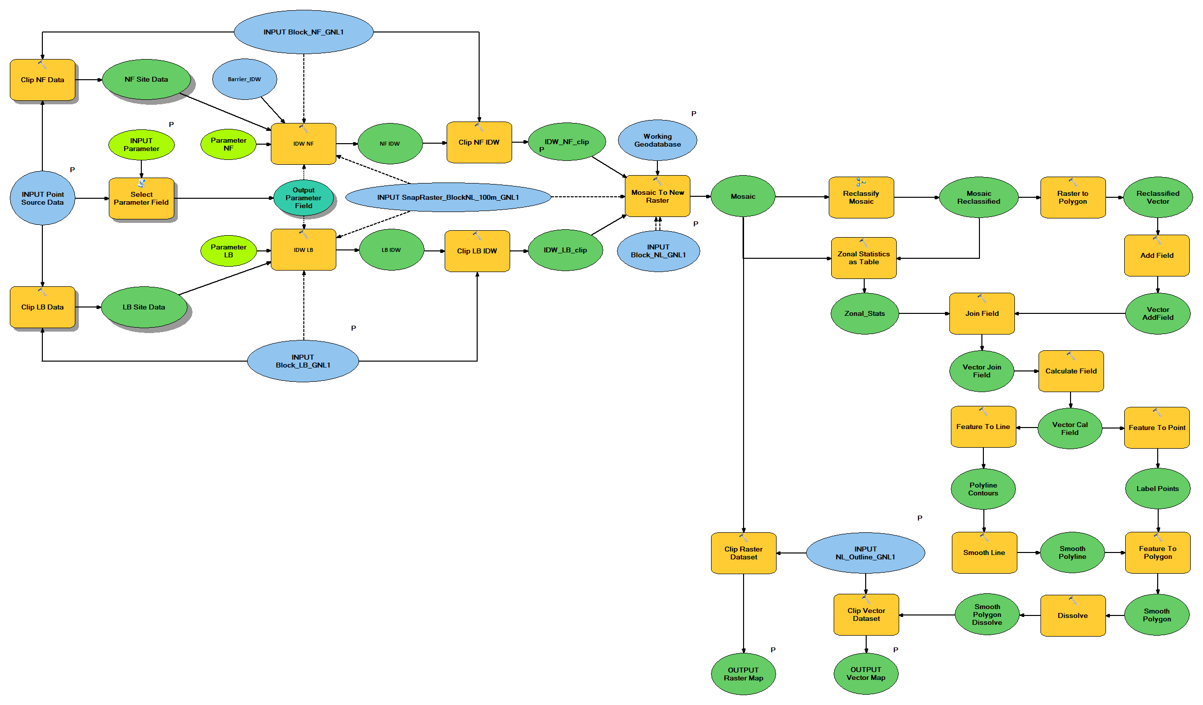
Attached is a pic of my model that shows two IDW tool components (i.e., the IDW NF and IDW LB tools).
The reason for having two IDW components is because I couldn’t get the barrier option to work, so I separated Newfoundland (NF) data from Labrador (LB) data, ran the IDW tools separately, and then mosaicked the results.
So I assumed the issue is with my model.
Upon further inspection of the model output, I realized that the ModelBuilder IDW NF tool was projecting results approximately 260 km to the west from where it should have been projected, and that’s why the output looked so strange; the contour lines weren’t corresponding with the sample points.
I checked model environment settings for projection discrepancies, but didn’t find any.
I then started deconstructing the model to pin point the source of the issue, and I pretty much deleted all tools with the exception of the IDW NF tool before the issue was resolved.
So now I’m in the process of rebuilding the model from the IDW NF tool.
I’m hoping I can get it to work.
If not, is it ok to contact you using this email chain?
Let me know if you want me to send you more info or data.
Thanks for your time and help,
Keith
~~~~~~~~~~~~~~~~~~~~~~~~~~~~~~
Keith Abbott
Environmental Scientist
Government of Newfoundland & Labrador
Department of Municipal Affairs & Environment
Water Resources Management Division
4th Floor, Confederation Building, West Block
PO Box 8700, St, John's, NL, A1B 4J6
t. 709.729.1331
f. 709.729.0320
e. keithnabbott@gov.nl.ca<mailto:keithnabbott@gov.nl.ca>
- Mark as New
- Bookmark
- Subscribe
- Mute
- Subscribe to RSS Feed
- Permalink
- Report Inappropriate Content
- Mark as New
- Bookmark
- Subscribe
- Mute
- Subscribe to RSS Feed
- Permalink
- Report Inappropriate Content
Hi Steve,
Thank you for your response.
I spent most of the day working on the IDW tool issue, with the intention on sending you some data.
As it happens, I ran the IDW tool using the data I had packaged for you and there was no issue with the tool output. The IDW raster looked good when a barrier was imposed.
What I did differently this time was run the IDW tool outside the ModelBuilder environment. It was in ModelBuilder where I had the issue with the IDW tool.
Attached is a pic of my model that shows two IDW tool components (i.e., the IDW NF and IDW LB tools).
The reason for having two IDW components is because I couldn’t get the barrier option to work, so I separated Newfoundland (NF) data from Labrador (LB) data, ran the IDW tools separately, and then mosaicked the results.
So I assumed the issue is with my model.
Upon further inspection of the model output, I realized that the ModelBuilder IDW NF tool was projecting results approximately 260 km to the west from where it should have been projected, and that’s why the output looked so strange; the contour lines weren’t corresponding with the sample points.
I checked model environment settings for projection discrepancies, but didn’t find any.
I then started deconstructing the model to pin point the source of the issue, and I pretty much deleted all tools with the exception of the IDW NF tool before the issue was resolved.
So now I’m in the process of rebuilding the model from the IDW NF tool.
I’m hoping I can get it to work.
If not, is it ok to contact you using this email chain?
Let me know if you want me to send you more info or data.
Thanks for your time and help,
Keith
~~~~~~~~~~~~~~~~~~~~~~~~~~~~~~
Keith Abbott
Environmental Scientist
Government of Newfoundland & Labrador
Department of Municipal Affairs & Environment
Water Resources Management Division
4th Floor, Confederation Building, West Block
PO Box 8700, St, John's, NL, A1B 4J6
t. 709.729.1331
f. 709.729.0320
e. keithnabbott@gov.nl.ca<mailto:keithnabbott@gov.nl.ca>