- Home
- :
- All Communities
- :
- Products
- :
- ArcGIS Living Atlas of the World
- :
- Living Atlas Questions
- :
- What is the temporal availability for the MODIS Te...
- Subscribe to RSS Feed
- Mark Topic as New
- Mark Topic as Read
- Float this Topic for Current User
- Bookmark
- Subscribe
- Mute
- Printer Friendly Page
What is the temporal availability for the MODIS Terra/Aqua True Color imagery collection?
- Mark as New
- Bookmark
- Subscribe
- Mute
- Subscribe to RSS Feed
- Permalink
- Report Inappropriate Content
Hello,
I am trying to use the MODIS Terra/Aqua true color (with or without correction) from the Living Atlas in my web map. However, when I "time-enable" the imagery stream, I can only see as far back as 2012, and also nothing farther than 2013. Am I using the wrong imagery stream for the Atlas? Can anyone help me figure this out?
Solved! Go to Solution.
Accepted Solutions
- Mark as New
- Bookmark
- Subscribe
- Mute
- Subscribe to RSS Feed
- Permalink
- Report Inappropriate Content
The service info page at MODIS Service shows the time extent as:
[2012/06/01 00:00:00 UTC, 2018/04/17 00:00:00 UTC].
The end of the period will change, it is always the current day.
There might be minor data gaps in the time coverage, when the processed data is not available. Those gaps are very rare however.
You can reduce the time step to one day to see exactly what is available for each day.
I will be updating this service, and part of that update will be synchronizing time extent with the one provided by NASA GIBS. It looks like they completed the back-processing of all the available MODIS data, so when this update will be complete the time extent will start on 2002-02-24 for MODIS Terra and 2002-07-03 for MODIS Aqua.
- Mark as New
- Bookmark
- Subscribe
- Mute
- Subscribe to RSS Feed
- Permalink
- Report Inappropriate Content
Thanks Lucian,
Will I have to re-add the service in my web map or it will automatically update after you do? Also, when I check the service in AGOL, I see the following time range (1972-2017) which does not match that of the service you are referring to for some reason (image 1-2 below).

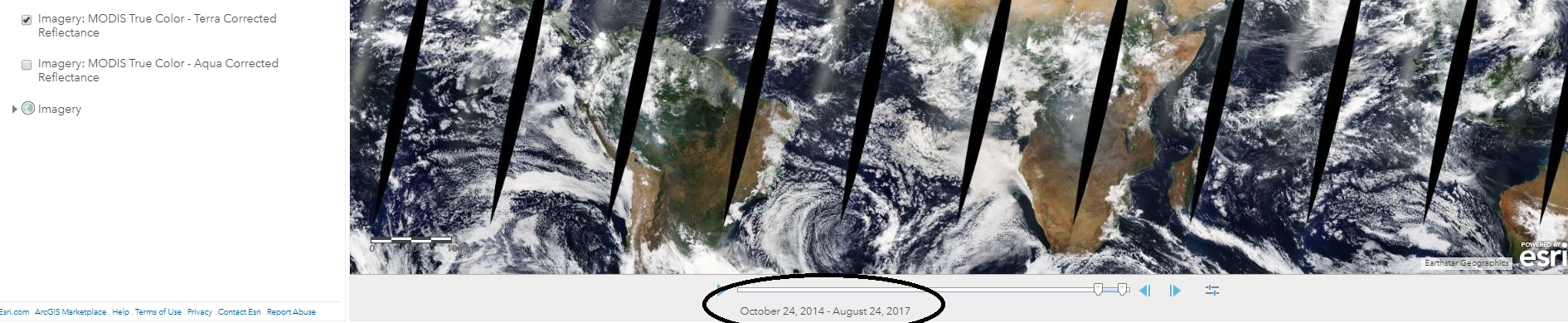
On top of this, when I use the ESRI IS imagery widgets in web appbuilder on the same exact service (see image 3 below), it only shows up to October 2013...no matter what area I zoom in...this for example is over the USA, North Carolina. Any ideas why these mismatches (above and below)?

- Mark as New
- Bookmark
- Subscribe
- Mute
- Subscribe to RSS Feed
- Permalink
- Report Inappropriate Content
The server update will keep the service name the same, so it should not require any changes. The update is only planned at this point, not imminent.
I can't answer your other questions, I only work on the server itself, sorry! Starting the "ArcGIS Online Viewer" from the MODIS (ImageServer) does show the right period.
- Mark as New
- Bookmark
- Subscribe
- Mute
- Subscribe to RSS Feed
- Permalink
- Report Inappropriate Content
Lucian, does it also display for you as if the whole chunk of imagery over the USA and west of it is black/missing?
- Mark as New
- Bookmark
- Subscribe
- Mute
- Subscribe to RSS Feed
- Permalink
- Report Inappropriate Content
You mean for the current day (JS viewer)? It is not missing, that is today, the data for that region has not been received from the satellite and processed yet. Wait a couple of hours and it will fill in.