- Home
- :
- All Communities
- :
- Products
- :
- Imagery and Remote Sensing
- :
- Imagery Questions
- :
- Mosaic Dataset vs. Raster
- Subscribe to RSS Feed
- Mark Topic as New
- Mark Topic as Read
- Float this Topic for Current User
- Bookmark
- Subscribe
- Mute
- Printer Friendly Page
Mosaic Dataset vs. Raster
- Mark as New
- Bookmark
- Subscribe
- Mute
- Subscribe to RSS Feed
- Permalink
- Report Inappropriate Content
I have multiple rasters (WGS 1984) that when combined in a mosaic dataset do not line up with the original rasters. They are off by about 3-5 feet from the original. Anyone have any ideas as to what is going on here? I'm keeping the coordinates the same and using the default properties. See the attached image and properties.
Solved! Go to Solution.
Accepted Solutions
- Mark as New
- Bookmark
- Subscribe
- Mute
- Subscribe to RSS Feed
- Permalink
- Report Inappropriate Content
For anyone curious, I figured out what was going on. The mosaic when brought into a WGS 1984 map lined up perfectly. When I brought it into a NAD 1983 map and let it re-project on the fly (which is what I had been doing) it was off by 3-5 feet. When I brought it into a NAD 1983 map and instead set the transformation using WGS_1984_(ITRF00)_To_NAD_1983 it came in fine.
- Mark as New
- Bookmark
- Subscribe
- Mute
- Subscribe to RSS Feed
- Permalink
- Report Inappropriate Content
Strange. This should not be the case. I suggest: Open the properties of the raster dataset. Review the georeferencing components. In the mosaic dataset open the table, select the same raster and open the function chain of the raster and open the georeferencing section. Do the values vary? I noticed that you are using imagery in DD so some of the georeferencing values will need to be defined to many decimal places. Is there a difference?
- Mark as New
- Bookmark
- Subscribe
- Mute
- Subscribe to RSS Feed
- Permalink
- Report Inappropriate Content
I'm not seeing the georeferencing components in properties... Where in environments might I find where to define the decimal places? I was messing with cell size and attempting to keep it the same although it didn't make a difference.
Also it's a mosaic dataset, not a raster dataset...
- Mark as New
- Bookmark
- Subscribe
- Mute
- Subscribe to RSS Feed
- Permalink
- Report Inappropriate Content
It appears the mosaic dataset has a number of different rasters in it. Can you create a new mosaic dataset and add one raster to it. Check if there is any difference. If not add another raster (in a very different location) and see if there is a difference. If so, create a new mosaic dataset with only that one raster and see if there is a difference. Typically the only reason I could foresee a difference is if: A) The datum of the data is different. B)There is some inaccuracy in the precision (checked using above). C) There are conflicting georeferencing (eg there is a JPW file or something that is defining another georeferencing).
- Mark as New
- Bookmark
- Subscribe
- Mute
- Subscribe to RSS Feed
- Permalink
- Report Inappropriate Content
1. The shift still occurs when only one raster is added.
2. The datum is D_WGS_1984 for both mosaic and raster.
- Mark as New
- Bookmark
- Subscribe
- Mute
- Subscribe to RSS Feed
- Permalink
- Report Inappropriate Content
1. Is the shift constant across the mosaic dataset?
2. Can you run the process with a single raster? Take one raster, add it to a mosaic dataset. Compare the original raster dataset against the newly created mosaic dataset. Do you still see the shift?
3. Is there a difference in the client SRS and the mosaic dataset SRS? (difference in Datum)
- Mark as New
- Bookmark
- Subscribe
- Mute
- Subscribe to RSS Feed
- Permalink
- Report Inappropriate Content
1. Yes
2. The shift still occurs when only one raster is added.
3. Datums are both: D_WGS_1984
- Mark as New
- Bookmark
- Subscribe
- Mute
- Subscribe to RSS Feed
- Permalink
- Report Inappropriate Content
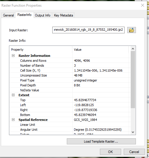
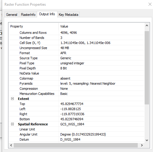
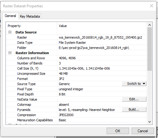
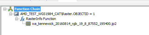
Can you provide a screenshot of the function raster? Right click the footprint -> Load the attribute table. edit the raster field. Send a screenshot of the function chain, and then a screenshot of the raster info .
Would be best if you can provide one sample image.
- Mark as New
- Bookmark
- Subscribe
- Mute
- Subscribe to RSS Feed
- Permalink
- Report Inappropriate Content
- Mark as New
- Bookmark
- Subscribe
- Mute
- Subscribe to RSS Feed
- Permalink
- Report Inappropriate Content
In this link
https://community.esri.com/servlet/JiveServlet/showImage/2-763100-401032/FunctionChain.PNG can you double click the raster info function and then double click the .jp2 raster. Compare the 2 contents, they should be the same.
Any way you can share a raster?