- Home
- :
- All Communities
- :
- Products
- :
- ArcGIS Spatial Analyst
- :
- ArcGIS Spatial Analyst Questions
- :
- water shed tool producing an unnaturally huge catc...
- Subscribe to RSS Feed
- Mark Topic as New
- Mark Topic as Read
- Float this Topic for Current User
- Bookmark
- Subscribe
- Mute
- Printer Friendly Page
water shed tool producing an unnaturally huge catchment
- Mark as New
- Bookmark
- Subscribe
- Mute
- Subscribe to RSS Feed
- Permalink
- Report Inappropriate Content
While using the watershed tool i am getting unnaturally huge catchment area. can it be a fault of the DEM i am using ( got from USGS-earth data website). Any suggestions please?
- Mark as New
- Bookmark
- Subscribe
- Mute
- Subscribe to RSS Feed
- Permalink
- Report Inappropriate Content
you should outline the steps that you used to prepare the dem for use in delineating a watershed. There are several issues that can cause strange outputs, not the least of which is the coordinate system used and the units of x, y and z. Outline what you have done and perhaps show an image of what you obtained versus what you expect so that 'large' can be assessed
- Mark as New
- Bookmark
- Subscribe
- Mute
- Subscribe to RSS Feed
- Permalink
- Report Inappropriate Content
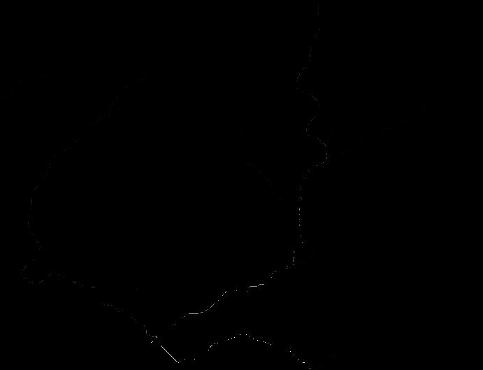
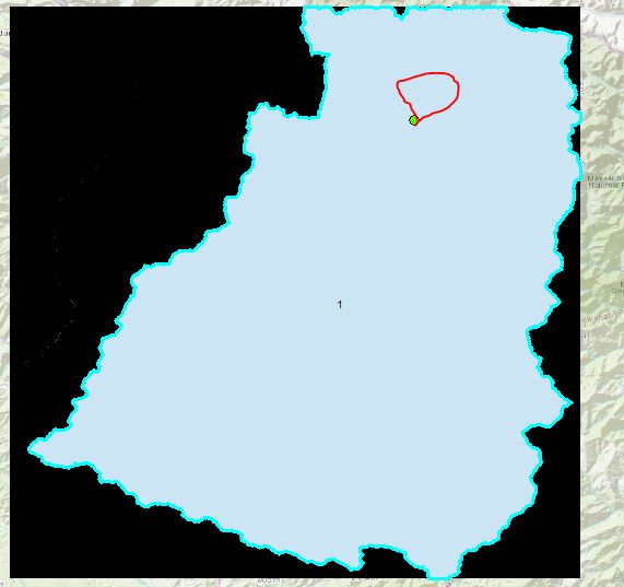
Thanks Dan for your response. I followed the following steps: Fill-Flow Dir-Flow Acc-Con( Value>500) - Stream Order-Stream to feature-Snap Pour Point( the distance didnt mattter if i used 5 or 500), Watershed( used processing extent as that of my DEM). I used wgs1984 projection throughout. i have added some pictures to clarify my
problem. the actual watershed as obtained from a paper toposheet is very small as compared to what was obtained from the watershed tool in arcmap.
- Mark as New
- Bookmark
- Subscribe
- Mute
- Subscribe to RSS Feed
- Permalink
- Report Inappropriate Content
your coordinates are in decimal degrees and your elevation is in meters. you would be advised to use projected data.. wgs84 is not a projection, but a datum
- Mark as New
- Bookmark
- Subscribe
- Mute
- Subscribe to RSS Feed
- Permalink
- Report Inappropriate Content
i am not an expert in these matters but i see what you are saying, because the cell size (x,y) is 0.00027777778, 0.00027777778 which cant be in meters. Can you please specifically advise me on how to get this right. I tried projecting it to Mercator, but then it got completely lost from the base map.
- Mark as New
- Bookmark
- Subscribe
- Mute
- Subscribe to RSS Feed
- Permalink
- Report Inappropriate Content
If your Project operation was successful, the basemap should draw correctly. Did you use the Project Raster tool? Having the raster data properly projected must happen before you start (with the Fill step).
- Mark as New
- Bookmark
- Subscribe
- Mute
- Subscribe to RSS Feed
- Permalink
- Report Inappropriate Content
Note, I'm pretty sure I know what happened. Your SnapPour gave a tolerance to snap your pour point to the largest value with 5 <units>. Those units were 5 degrees, which is 300 nautical miles, so your point snapped to the highest flow accumulation cell in the raster.
- Mark as New
- Bookmark
- Subscribe
- Mute
- Subscribe to RSS Feed
- Permalink
- Report Inappropriate Content
I just recently delineated my own watershed using a DEM as well. I was looking at your steps and compared them to my own. My steps are as follows: Fill -> Flow Direction -> Flow Accumulation -> Con -> Stream Order -> Stream to Feature -> Basin -> Raster to Polygon -> (Created my pour point and placed in the raster cell(s) from the FlowAccumulation layer) ->Snap Pour Point -> and then Watershed. Hope this helps! I have step by step directions if you want them as well for how I did it.