- Home
- :
- All Communities
- :
- Products
- :
- ArcGIS Spatial Analyst
- :
- ArcGIS Spatial Analyst Questions
- :
- Arcmap crashing/shutting down
- Subscribe to RSS Feed
- Mark Topic as New
- Mark Topic as Read
- Float this Topic for Current User
- Bookmark
- Subscribe
- Mute
- Printer Friendly Page
Arcmap crashing/shutting down
- Mark as New
- Bookmark
- Subscribe
- Mute
- Subscribe to RSS Feed
- Permalink
- Report Inappropriate Content
Hi,
I have a problem with my Arcmap (v.10.3.1), I am trying to use the contour tool using the deriving data from my DTM (8mt) but it doesn't work. I used this file for other tool and it always worked. Anyway, I presumed that it was the file the problem, so I started to use the Slope file as attempt but when I try to use the contour tool Arcmap crashes blocking itself or shutting down directly.
In your opinion, what could be the cause?
Thank you in advance
Regards
Roberto
- Mark as New
- Bookmark
- Subscribe
- Mute
- Subscribe to RSS Feed
- Permalink
- Report Inappropriate Content
Not enough information.
source and type of data?
nature and location of files?
computer specs?
Just this data? or any data?
Only you? or anyone on your machine?
That should get you started.
PS
Is this a Discussion? or did you mean to make it a Question?
- Mark as New
- Bookmark
- Subscribe
- Mute
- Subscribe to RSS Feed
- Permalink
- Report Inappropriate Content
Actually it is a question...
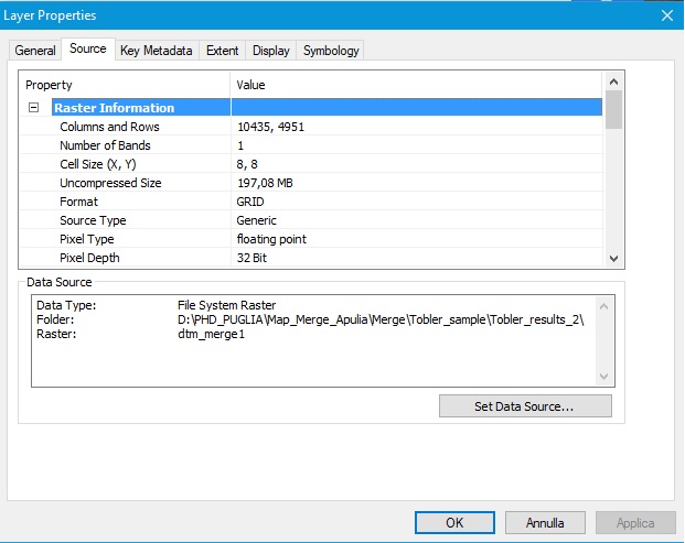
So, the DTM (8x8 cell and it is a merging result form other form the same source) comes from the Apulia Region website (Italy), I used it for all my process in Arcmap. But I don't know now it didn't work... I used the DTM for applying the Tobler's function as described here: Week 9 - Anisotropic cost surfaces and Least-cost paths | www.MapAspects.org . So it worked up to the Path Distance (part B, step2), but just once.
So I tried to use another method (ArcGIS Tutorial: Tobler's Hiking Function | Kaitlin Hakanson - Academia.edu ), but in this case the DTM didn't work at all. So, just as attempt I used the Slope (generated from the DTM), it worked up to the point 4, because when I tried to use the contour tool Arcmap crashed or shutted down directly.
The file are stored in a separated folder in the second HD subdivision, that it is not that one in which was installed the program and where it is the default database (but since now I worked like this without problem), in my laptop (the only machine with which I used to work).
I attached some specs on my DTM and PC (you have to consider that the HD subdivision in which is installed ArcGIS has free 95.4 GB on 372GB (276GB used); while the second one 487 GB free on 537 GB (49.6 GB used).
I hope that in this way it is more clear.
Thank you in advance.
Regards
Roberto


- Mark as New
- Bookmark
- Subscribe
- Mute
- Subscribe to RSS Feed
- Permalink
- Report Inappropriate Content
It is projected, it is a big file and you are doing this in arcmap.
Try it in PRO which will use your available memory which is still pretty slim for raster analysis like that.
To test... clip out a small area, use it to make sure there is nothing wrong with the file type etc.
I suspect it is your resources
The cpu memory and video memory recommendations for ArcMap and PRO should be considered the absolute minimum... to use on a good day with small-ish files...
For big stuff, tiling, mem-mapping and other workarounds can come into play.
To see what is actually going on, run your system monitoring when you run tools with rasters and observe..
- Mark as New
- Bookmark
- Subscribe
- Mute
- Subscribe to RSS Feed
- Permalink
- Report Inappropriate Content
Dear Dan,
Thank you for your suggestions... I observed the monitoring system and actually the RAM involved it was almost the 70% using the contour tool, yet it stopped at the 6% so I thing it was a memory problem. Therefore, I tried to clip my DTM and I followed the steps as in the guideline (ArcGIS Tutorial: Tobler's Hiking Function | Kaitlin Hakanson - Academia.edu). It worked correctly up to the point 4, yet when I used the contour tool it didn't work again (it reached the 3/4%) then I launched the tool a second and a third times but it failed directly.
So, I guess that I should attempt to do it in PRO (as you said) or maybe to expand my RAM, just because the file clipped or not seem to work for the other tools.
Thanks
Regards
Roberto
- Mark as New
- Bookmark
- Subscribe
- Mute
- Subscribe to RSS Feed
- Permalink
- Report Inappropriate Content
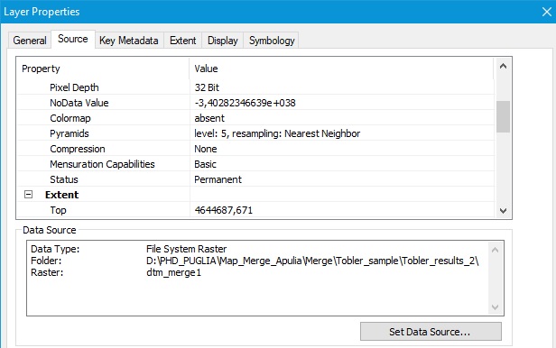
So your raster has 10,435 * 4,951 = 51,663,685 pixels and usig a pixel depth of 32 bits (4 bytes per pixel) results in a raster of 197.08MB. This is really not very big considering the fact that I have processed rasters in the past with a size of 30GB (although I did use SSD drives for fast IO).Also have a look here: FAQ: What is the maximum size a raster Grid can be?
You are using a Esri Grid raster and a path that is pretty long and it might be good to make the path shorter (see storage limitations in this topic: Esri Grid format—Help | ArcGIS Desktop ).It might also be more efficient to work with a raster inside a File Geodatabase. If tools are not working, there might be something wrong with your data.
- Mark as New
- Bookmark
- Subscribe
- Mute
- Subscribe to RSS Feed
- Permalink
- Report Inappropriate Content
Thank you for the reply Xander, I tried to make shorter the path and putting the data bulk into a unique geodatabase but I still continue to have problem only using the path distance tool. It sounds strange because I used the same DTM for cost distance, euclidean distance, cost path, slope, viewshed tools with reasonable results. Moreover, although the DTM was obtained from a merging, all the single DTM tiles come from an official site. Could it be the use of the Tobler's function table (as explained both in the web page link and in the academia.edu link)?
- Mark as New
- Bookmark
- Subscribe
- Mute
- Subscribe to RSS Feed
- Permalink
- Report Inappropriate Content
The Path Distance—Help | ArcGIS Desktop tool is a pretty complex tool with a lot of optional parameters. Can you specify which parameters are you using and what ranges of values the raster have that you are using for the parameters? Is it possible to attach (part of) the data?
- Mark as New
- Bookmark
- Subscribe
- Mute
- Subscribe to RSS Feed
- Permalink
- Report Inappropriate Content
So the path distance worked, but I still have problem (that it is the hardest now) with the contour tool, since when I launch after a while ArcGIS shuts down or crashes or blocks. So I tried to attached here my files, but without success... If it is possible, may I have your email in order to send you?
Thank your for your patience and time.
Regards
Roberto
- Mark as New
- Bookmark
- Subscribe
- Mute
- Subscribe to RSS Feed
- Permalink
- Report Inappropriate Content
I don't believe that the size of the raster alone is causing the crash. I think that the contour interval, ArcMap v10.3.1, 32 bit processing and the size of the raster are the causes (listed in order).
Let us try and debug the problem;
- Slope works, this means that the raster is not corrupted
- use a larger contour interval (what is the min/max value in the raster?)
- if the above works, then it is a memory issue, we've added more error checks in subsequent versions.
-Steve