- Home
- :
- All Communities
- :
- User Groups
- :
- Cartography and Maps
- :
- Questions
- :
- How do you solve multiple contour lines unions at ...
- Subscribe to RSS Feed
- Mark Topic as New
- Mark Topic as Read
- Float this Topic for Current User
- Bookmark
- Subscribe
- Mute
- Printer Friendly Page
How do you solve multiple contour lines unions at once?
- Mark as New
- Bookmark
- Subscribe
- Mute
- Subscribe to RSS Feed
- Permalink
- Report Inappropriate Content
I have a huge contour lines fature layer that has many miss unions among them. Editing each contour line to fix the union, takes me a lot of time. Do you know some methodology or tool to deal with this issue?
- Mark as New
- Bookmark
- Subscribe
- Mute
- Subscribe to RSS Feed
- Permalink
- Report Inappropriate Content
you can try snapping but the line may or may not snap to where they should.
Personal your best bet is to make an entirely new contour layer from RAW data or a DEM
There is so much LIDAR data available out there that it really not that big a deal. I recently created a whole new set of contour line in a half mile buffer around all or our transmission lines.
What is your region or state>?
- Mark as New
- Bookmark
- Subscribe
- Mute
- Subscribe to RSS Feed
- Permalink
- Report Inappropriate Content
Thanks for your answer. I live in Quito Ecuador, South America. The point is that I got the contour lines from a DEM and the outcome came with errors like these ones:
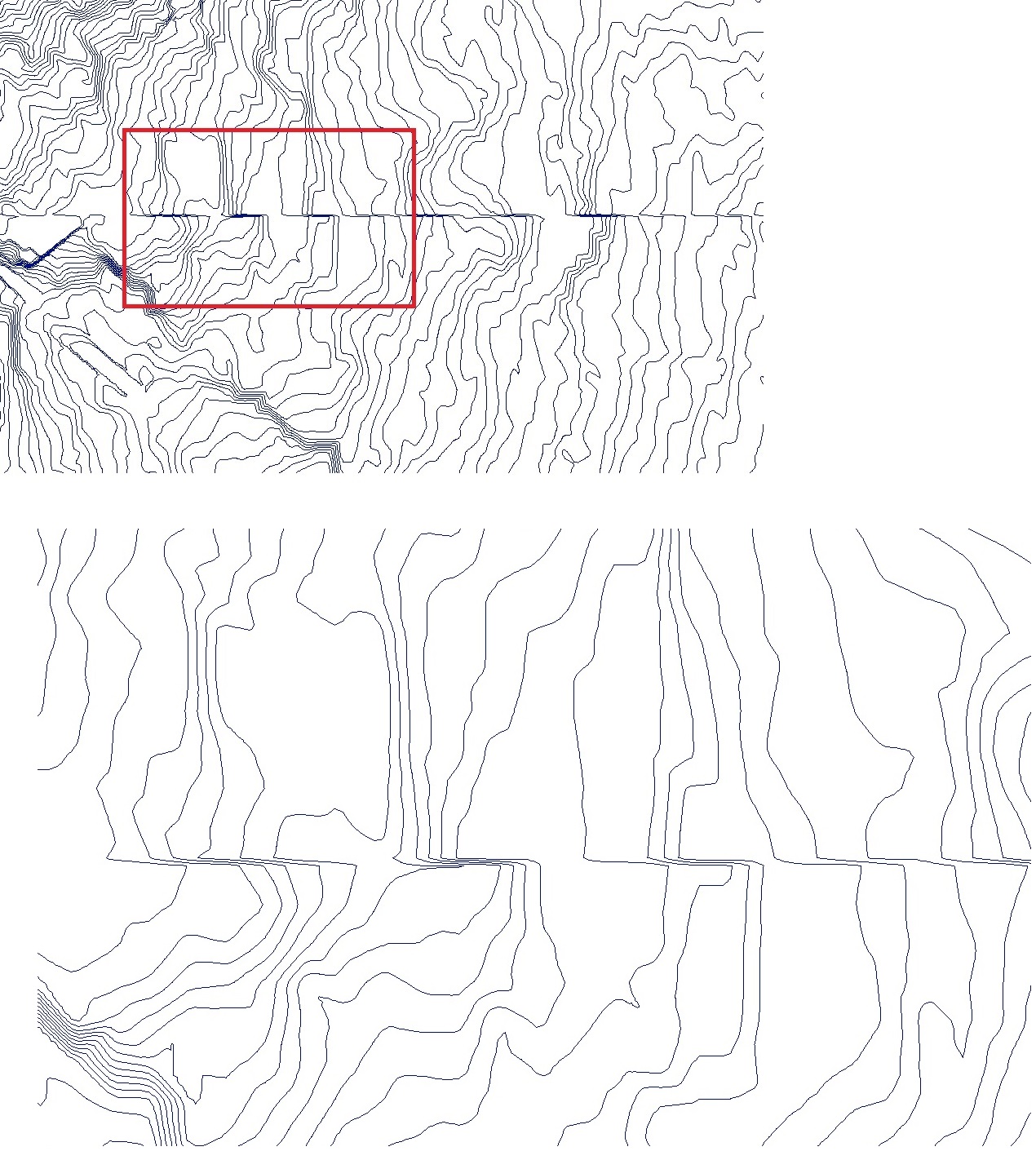
and now I'm looking the suitable way to correct them. The file is huge and the editing is terrible slow. We don´t have lidar for the total area, perhaps there are lidar information from some scatered areas.
- Mark as New
- Bookmark
- Subscribe
- Mute
- Subscribe to RSS Feed
- Permalink
- Report Inappropriate Content
That is a common error that can be found in any situation where edge matching of contours (or any shape for that matter) occurs on the edges. The projection of the data might be something like a UTM I suspect. There is no way of auto-correcting what you see. If you had the original DEM (ie point values, you could redo the contouring yourself. If you simply have the raster, then any sort of filtering will just produce other artifacts.
- Mark as New
- Bookmark
- Subscribe
- Mute
- Subscribe to RSS Feed
- Permalink
- Report Inappropriate Content
Thanks Dan. Ok, I undersatnd there is no way of auto-correcting the miss matching errors of contours. Now, can you tell me what would be the possible parameters or switchs I have to take into account in order to obtain a better contours from the DEM?, otherwise I'll get the same outcome.
- Mark as New
- Bookmark
- Subscribe
- Mute
- Subscribe to RSS Feed
- Permalink
- Report Inappropriate Content
The only way to get rid of the artifact is to re-contour the dem data with a fully stitched set of data. However, if the DEM raw data shows that artifact as well, so will the contours.
You could try filtering the (smoothing) the original data, but that raises other issues. Or you could try smoothing the contours, but that would be horrendous elsewhere.
Manual correction, if it is mission critical. I have yet to see any solution that applies to all situations.
- Mark as New
- Bookmark
- Subscribe
- Mute
- Subscribe to RSS Feed
- Permalink
- Report Inappropriate Content
Ok, thanks for your help
- Mark as New
- Bookmark
- Subscribe
- Mute
- Subscribe to RSS Feed
- Permalink
- Report Inappropriate Content
After seeing the image I am thinking that the DEM tiles were not edge matched properly in the first place.
- Mark as New
- Bookmark
- Subscribe
- Mute
- Subscribe to RSS Feed
- Permalink
- Report Inappropriate Content
I suspect the tiles were projected, then contoured individually. If the data were in geographic coordinates, merged, then projected this artifact wouldn't show.
I have seen it with all our country's data ... thematic or contour, when maps are produced at various scales individually. The 'seam' issue is common