- Home
- :
- All Communities
- :
- Products
- :
- ArcGIS Pro
- :
- ArcGIS Pro Questions
- :
- Problem: ArcGIS Pro 2.1 Basemap poor quality when ...
- Subscribe to RSS Feed
- Mark Topic as New
- Mark Topic as Read
- Float this Topic for Current User
- Bookmark
- Subscribe
- Mute
- Printer Friendly Page
Problem: ArcGIS Pro 2.1 Basemap poor quality when exporting layout to PDF
- Mark as New
- Bookmark
- Subscribe
- Mute
- Subscribe to RSS Feed
- Permalink
- Report Inappropriate Content
In ArcGIS Pro 2.1.1 the quality of the basemap after exporting the layout to a pdf file is very poor and seems be to converted into tiles (which sometimes are even rendered individually at different quality). Everything but the basemap is in a very fine quality, it's basically just the basemap.
When I create a complete new project, with a fresh basemap and a new layout file, the quality of the basemaps (any arcgis online basemap) after exporting is very poor. When I export the image from the map view, however, the quality is fine (just as displayed on the screen). The quality on screen in the layout view is fine, it's the pdf file where the problems occurs.
I have tried multiple basemaps and nearly all possible combinations in export settings, but the problem persists. The issue started to happen just a few days ago, before this I've never had this problem before.
Has anyone had similar issues and/or could anyone suggest a solution?
Solved! Go to Solution.
Accepted Solutions
- Mark as New
- Bookmark
- Subscribe
- Mute
- Subscribe to RSS Feed
- Permalink
- Report Inappropriate Content
As I suspected it had something to do with settings and/or files related to ArcGIS Pro. The solution for me was to do the following:
- Unauthorize offline use for ArcGIS Pro on the computer.
- Uninstall ArcGIS Pro using Windows 10
- Delete the following (if not already gone):
- C:\Users\<username>\AppData\Local\ESRI\ArcGISPro and every other ArcGIS Pro folder:
- C:\Users\username\AppData\Roaming\ESRI\ArcGISPro
- C:\Program Files\ArcGIS\Pro
- Remove these folders in the registry:
- HKEY_CURRENT_USER\Software\ESRI\ArcGISPro
- HKEY_CURRENT_USER\Software\ESRI\ArcGISPro1.0
- Reboot the PC and re-install ArcGIS Pro.
In this new, fresh, installation the problem does not occur. I hope it might help anyone else with this problem.
- Mark as New
- Bookmark
- Subscribe
- Mute
- Subscribe to RSS Feed
- Permalink
- Report Inappropriate Content
What are the exact steps you are executing to export to PDF? Screen shots and exact steps to reproduce would help. There are many, many, many settings in Pro -> Share -> PDF that could cause this. By not compressing graphics, when I export to PDF, basemap looks perfect.
- Mark as New
- Bookmark
- Subscribe
- Mute
- Subscribe to RSS Feed
- Permalink
- Report Inappropriate Content
Hi Liedeke Reitsma ,
Some questions to start with:
- What scale are you using?
- What base map are you using?
- What settings are you using for the export to PDF?
- What are the settings of the layers yo display on top? Do they have transparency?
Perhaps for these type of problems it is best to contact Esri Nederland (http://www.esri.nl/ ) directly.
- Mark as New
- Bookmark
- Subscribe
- Mute
- Subscribe to RSS Feed
- Permalink
- Report Inappropriate Content
I've basicly used a large range of basemaps (all have the same problem). Export options, i've used basicly every checkbox combination possible at 100, 300, 600 and 1200 dpi. And, as stated in my question, have tried to make a clean and fresh map without any layers whatsoever.
- Mark as New
- Bookmark
- Subscribe
- Mute
- Subscribe to RSS Feed
- Permalink
- Report Inappropriate Content
I would recommend you two things.
- Report this to Esri Nederland, since I do notice a difference in quality between exporting the layout and exporting the map frame
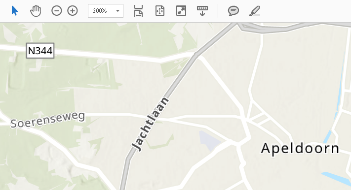
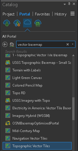
- Use the Topographic Vector Tile basemap
Using a vector tile base map really gives a much better quality of the output PDF (here zoomed in to 200% or the PDF):
- Mark as New
- Bookmark
- Subscribe
- Mute
- Subscribe to RSS Feed
- Permalink
- Report Inappropriate Content
Hi Xander,
The vector basemap (only world topographic one) works a treat, very true. It's a shame that the beautiful topographic one combined with height for Holland (RD, ESRINL) does not. I tried searching basemap, vector. This RD one pops up but doesn't load, i suspect there are a few around. This last map is very useful when mapping terrain, which is what we do most. So it seems that despite al the fun and beautiful developments we still can't use the basemaps we want to on a regular and steady basis. Which is a real shame. But ah well, thanks for your tip on vectors!
- Mark as New
- Bookmark
- Subscribe
- Mute
- Subscribe to RSS Feed
- Permalink
- Report Inappropriate Content
I would reach out to Esri Nederland directly. Since they are the owner of the data, they may have additional recommendations to use them or other sources that you can use as alternative.
- Mark as New
- Bookmark
- Subscribe
- Mute
- Subscribe to RSS Feed
- Permalink
- Report Inappropriate Content
Thanks Xander for your reply, you have been kindly helpful!
Liedeke
- Mark as New
- Bookmark
- Subscribe
- Mute
- Subscribe to RSS Feed
- Permalink
- Report Inappropriate Content
As I suspected it had something to do with settings and/or files related to ArcGIS Pro. The solution for me was to do the following:
- Unauthorize offline use for ArcGIS Pro on the computer.
- Uninstall ArcGIS Pro using Windows 10
- Delete the following (if not already gone):
- C:\Users\<username>\AppData\Local\ESRI\ArcGISPro and every other ArcGIS Pro folder:
- C:\Users\username\AppData\Roaming\ESRI\ArcGISPro
- C:\Program Files\ArcGIS\Pro
- Remove these folders in the registry:
- HKEY_CURRENT_USER\Software\ESRI\ArcGISPro
- HKEY_CURRENT_USER\Software\ESRI\ArcGISPro1.0
- Reboot the PC and re-install ArcGIS Pro.
In this new, fresh, installation the problem does not occur. I hope it might help anyone else with this problem.
- Mark as New
- Bookmark
- Subscribe
- Mute
- Subscribe to RSS Feed
- Permalink
- Report Inappropriate Content
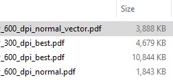
I am having the same exact very frustrating problem. Exporting a layout to PDF results in very poor quality basemaps in the PDF. I have exported with various basemaps, both raster and vector, with varying dpi and image quality with no success. I have attached screenshots of what I am seeing below. Exporting with "Best" image quality results in a better quality PDF but increases the size of the PDF to from 1,843 KB (Normal) to 10,844 KB (Best).
I am using ArcGIS Pro 2.2.4
300dpi & Best Image Quality with Raster Basemap
600dpi & Normal Image Quality with Raster Basemap
600dpi & Best Image Quality with Raster Basemap
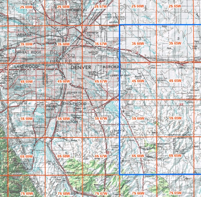
600dpi & Normal Image Quality with Vector Basemap
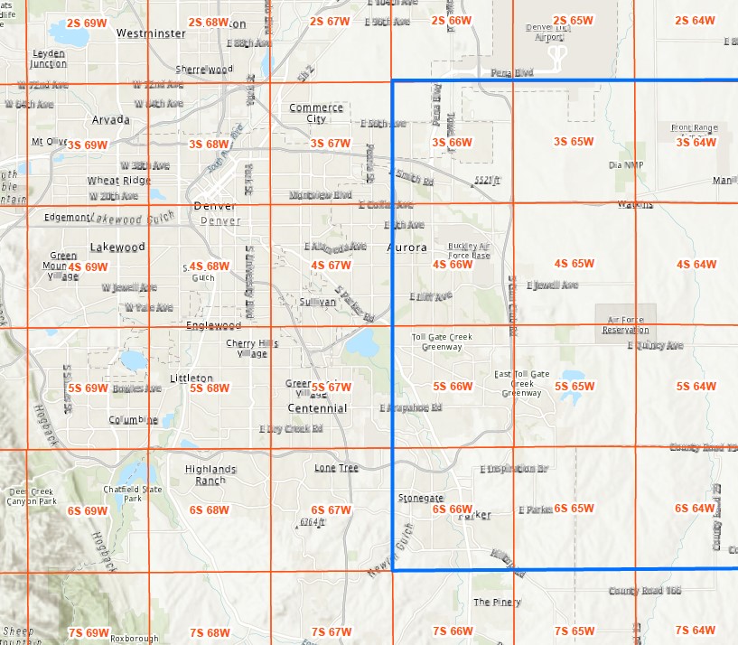
File Sizes
I have read the above suggestion from Liedeke Reitsma but I recently had to reinstall windows on my computer and install a clean version of ArcGIS Pro so I don't think this would solve the problem.
Please help!