- Home
- :
- All Communities
- :
- User Groups
- :
- New to GIS
- :
- Questions
- :
- How to troubleshoot a dissolve that returns empty ...
- Subscribe to RSS Feed
- Mark Topic as New
- Mark Topic as Read
- Float this Topic for Current User
- Bookmark
- Subscribe
- Mute
- Printer Friendly Page
How to troubleshoot a dissolve that returns empty output.
- Mark as New
- Bookmark
- Subscribe
- Mute
- Subscribe to RSS Feed
- Permalink
- Report Inappropriate Content
I have a map layer containing election district boundaries. All of the election districts are located within towns. As a learning task, I'm attempting to dissolve the boundaries of the constituent districts to create a town shape layer. I have a few statistical fields in the layer that I would like to sum when I dissolve the district boundaries.
I've tried using the Dissolve command, but keep finding it returns an empty table (" WARNING 000117: Warning empty output generated."). I'm also unclear on what to enter in the Output feature class field. By default the field seems to be populated with the name of another shape layer in my project, but I don't want to overwrite that layer.
After reading some forum posts, I thought maybe my geometry was corrupted. I tried the Check Geometry tool, which did return an error (" WARNING 000442: could not find spatial index at -1 in Westchester 2014_Town boundaries"). I also tried the Repair Geometry tool which ran successfully. However, when running the dissolve command I still am getting empty output.
Solved! Go to Solution.
Accepted Solutions
- Mark as New
- Bookmark
- Subscribe
- Mute
- Subscribe to RSS Feed
- Permalink
- Report Inappropriate Content
If you make a join by most methods... they are temporary and can be removed. ie (Add Join tool temporary)
You make permanent joins by using Join Field or by saving the the results of Add Join using several options (ie Copy Tool for instance)
- Mark as New
- Bookmark
- Subscribe
- Mute
- Subscribe to RSS Feed
- Permalink
- Report Inappropriate Content
Assuming you are using Dissolve in Data Management
Your input parameters are listed as
Dissolve_management (in_features, out_feature_class, {dissolve_field}, {statistics_fields}, {multi_part}, {unsplit_lines})
The first two are your input featureclass and its output (Dissolve has to produce a new file).
The 3rd is asking what field are you using for the dissolve? do you have a field with the Town names? If so, that would be the one. other parameters... read about them since they provide other outputs information and also control how the geometry is treated
- Mark as New
- Bookmark
- Subscribe
- Mute
- Subscribe to RSS Feed
- Permalink
- Report Inappropriate Content
Shared to Geoprocessing
GeoNet Community Structure to get a wider audience
- Mark as New
- Bookmark
- Subscribe
- Mute
- Subscribe to RSS Feed
- Permalink
- Report Inappropriate Content
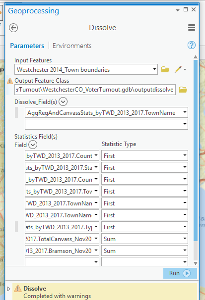
Yes, I used Town Names as the aggregation field:
- Mark as New
- Bookmark
- Subscribe
- Mute
- Subscribe to RSS Feed
- Permalink
- Report Inappropriate Content
good... but what were the warnings? At least it wasn't an error. Are they all text fields? since First seems to be the only option for most.
- Mark as New
- Bookmark
- Subscribe
- Mute
- Subscribe to RSS Feed
- Permalink
- Report Inappropriate Content
The only warning refers to the empty output: WARNING 000117: Warning empty output generated. I used First for any field that contains geography that would still apply to a town-level shapefile -- like country, state, and county. Since repeatedly re-specifying the Dissolve specs got a bit old, I only added a few of fields that need to be summed this time.
- Mark as New
- Bookmark
- Subscribe
- Mute
- Subscribe to RSS Feed
- Permalink
- Report Inappropriate Content
Do a query and select a single town as a test (select by attributes)
Export the selection to its own featureclass in a geodatabase on a local machine.
Try a dissolve on that
Your file paths are long and the names with the dots etc are a bit strange
- Mark as New
- Bookmark
- Subscribe
- Mute
- Subscribe to RSS Feed
- Permalink
- Report Inappropriate Content
The field names with the dots are the result of a join between the shapelayer and a data table. In case it was a memory issue, I retried running the dissolve on just the shapefile but no luck.
- Mark as New
- Bookmark
- Subscribe
- Mute
- Subscribe to RSS Feed
- Permalink
- Report Inappropriate Content
zip the shapefile... attach it to your question (may have to use the advanced editor option in the top right of the question).
I will check the dissolve.
Also, I wouldn't do a dissolve unless the joins were permanent in any event
- Mark as New
- Bookmark
- Subscribe
- Mute
- Subscribe to RSS Feed
- Permalink
- Report Inappropriate Content
I've attached the original shapefile that I downloaded from the public website. The 2 leftmost characters from the TWD text field indicate the town. I used that field to create a new field, Town. Then I imported TownNames by joining the shapelayer with a lookup table. I've placed the new shape layer with the 2 new fields in this layer package (which seems to be an exportable entity), and attached that here as well. Before attempting the dissolve, I did run repair geometry which deleted some features with null geometry.
Thanks again for your help.