- Home
- :
- All Communities
- :
- Products
- :
- ArcGIS Pro
- :
- ArcGIS Pro Questions
- :
- How can I convert coverages to something I can use...
- Subscribe to RSS Feed
- Mark Topic as New
- Mark Topic as Read
- Float this Topic for Current User
- Bookmark
- Subscribe
- Mute
- Printer Friendly Page
How can I convert coverages to something I can use in ArcGIS Pro?
- Mark as New
- Bookmark
- Subscribe
- Mute
- Subscribe to RSS Feed
- Permalink
- Report Inappropriate Content
I have coverages that my users in education downloaded from FAO... but they only have Pro and not ArcMap. How can they convert these coverages to something they can use in ArcGIS Pro? ... such as a shapefile or a gdb feature class?
Thank you.
--Joseph Kerski
Solved! Go to Solution.
Accepted Solutions
- Mark as New
- Bookmark
- Subscribe
- Mute
- Subscribe to RSS Feed
- Permalink
- Report Inappropriate Content
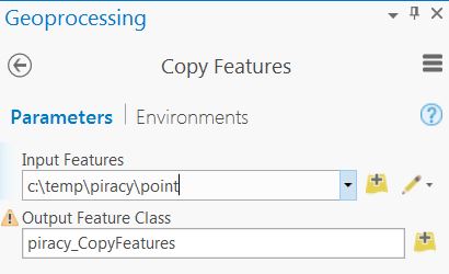
Here's a "Pro" tip I learned from Steve Lynch (Esri) today - use the Copy Features GP tool and for the Input Features parameter, type the full coverage path including the geometry to convert. Then define our Output Feature Class parameter to be a shapefile or gdb feature class. Voila! Coverage vector data converted with the core application.
- Mark as New
- Bookmark
- Subscribe
- Mute
- Subscribe to RSS Feed
- Permalink
- Report Inappropriate Content
Pro doesn't cover coverages and as you indicate you don't have arcmap.
Are you sure FAO only publishes coverages? Is there no other data source?
Maybe if you publish the link people could troll around for comparables for you. Otherwise, pre-converting and hosting somewhere may be an option if the data are mission-critical
ADDENDUM
They have there own portal
http://www.fao.org/geonetwork/srv/en/main.home?uuid=ac02a460-da52-11dc-9d70-0017f293bd28
and I also checked FAO , searched on 'shapefile' got a gazillion hits
perhaps you could specify the dataset that is needed rather than the 'coverage' aspect of the problem
- Mark as New
- Bookmark
- Subscribe
- Mute
- Subscribe to RSS Feed
- Permalink
- Report Inappropriate Content
The Data Interoperability Extension for Desktop would be one possible solution as it converts most Esri formats to *.gdb or *.shp.
- Mark as New
- Bookmark
- Subscribe
- Mute
- Subscribe to RSS Feed
- Permalink
- Report Inappropriate Content
Is Feature Class to Feature Class—Conversion toolbox | ArcGIS Desktop not working?
Summary
Converts a shapefile, coverage feature class, or geodatabase feature class to a shapefile or geodatabase feature class.
Think Location
- Mark as New
- Bookmark
- Subscribe
- Mute
- Subscribe to RSS Feed
- Permalink
- Report Inappropriate Content
Here's a "Pro" tip I learned from Steve Lynch (Esri) today - use the Copy Features GP tool and for the Input Features parameter, type the full coverage path including the geometry to convert. Then define our Output Feature Class parameter to be a shapefile or gdb feature class. Voila! Coverage vector data converted with the core application.
- Mark as New
- Bookmark
- Subscribe
- Mute
- Subscribe to RSS Feed
- Permalink
- Report Inappropriate Content
Cool! undocumented stuff is the best. Does the path have significance ? 
- Mark as New
- Bookmark
- Subscribe
- Mute
- Subscribe to RSS Feed
- Permalink
- Report Inappropriate Content
Very cool undocumented workflows! The path to piracy begins with yo-ho-ho and a bottle of rum! 😉
- Mark as New
- Bookmark
- Subscribe
- Mute
- Subscribe to RSS Feed
- Permalink
- Report Inappropriate Content
I thought it might have been an 'R workspace'
- Mark as New
- Bookmark
- Subscribe
- Mute
- Subscribe to RSS Feed
- Permalink
- Report Inappropriate Content
That's awesome! I conducted a Lesson Review for one of classes years ago that happened to fall on "International Talk Like a Pirate Day." I pulled up the Mighty Google and used the English to Pirate translator to properly phrase my questions. It was aaarrrr-guably the best lesson review of the day.
- Mark as New
- Bookmark
- Subscribe
- Mute
- Subscribe to RSS Feed
- Permalink
- Report Inappropriate Content
Hello and thank you to Robert! I am using this method to convert a large dataset of coverages across mulitiple directories. I found using wildcard naming conventions useful in sorting throughthe outputs. This is a nice article on that! https://pro.arcgis.com/en/pro-app/2.8/help/analysis/geoprocessing/modelbuilder/inline-variable-subst...