- Home
- :
- All Communities
- :
- Products
- :
- ArcGIS Pro
- :
- ArcGIS Pro Questions
- :
- Map Series Borks Projections... Can't Frame Withou...
- Subscribe to RSS Feed
- Mark Topic as New
- Mark Topic as Read
- Float this Topic for Current User
- Bookmark
- Subscribe
- Mute
- Printer Friendly Page
Map Series Borks Projections... Can't Frame Without Refreshing Series Manually
- Mark as New
- Bookmark
- Subscribe
- Mute
- Subscribe to RSS Feed
- Permalink
- Report Inappropriate Content
Referencing this Twitter conversation: https://twitter.com/andrewshears/status/946447640123838465
Cannot for the life of me figure out how to make page specific projections work in Map Series without refreshing between each and every map.
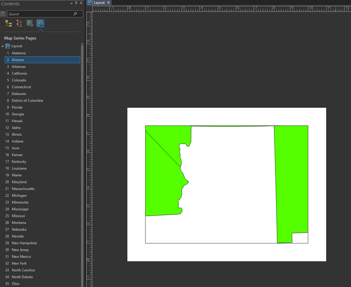
Simple example: using US states projected to NAD 1983 HARN as the feature layer for Map Series, file path in attribute table pointing to projection from each feature (all US state planes in HARN -- see attachment image) and it frames the features just.... really terribly. Doesn't matter if it's during the auto-export to PDF or if its by visiting the page in the layout.
HOWEVER, if you refresh the entire map series between viewing each page, the map is framed perfectly and in the proper projection.
Unfortunately, doing this entirely takes away the purpose of the map series feature -- to automate export of many layouts with one click.
So, my question is, WTF? Is it....
1) My projections are somehow messed up? Doesn't seem likely because they're all coordinated in terms of angular units, linear units, datum, geoid and base coordinate system. The filepaths in the attribute table are correct, the .prj files they point to are correct. And they work perfectly if refreshed. However, I'm certainly willing to learn what I did wrong here.
2) The Map Series isn't working right? I can't imagine this is a feature rather than a bug because.... well, why? Having to refresh the map series after each map would make the Map Series stuff no more useful than spatial bookmarks.
3) Not an intended use of the Map Series feature? If the Map Series feature doesn't exist to automate map production, why does it exist, and exactly how is this in any way better than the equivalent in QGIS?
I'm still using a trial version and was ready to pony up for ArcGIS Pro license thanks to the much faster processing and output that Arc offers over QGIS. However, if I can't do Map Series without walking the software through each and every page, then any savings in processing and output over QGIS for my use is absolutely lost.
Any help, advice or fixes is very much appreciated!
Solved! Go to Solution.
Accepted Solutions
- Mark as New
- Bookmark
- Subscribe
- Mute
- Subscribe to RSS Feed
- Permalink
- Report Inappropriate Content
I wanted to close the loop on this issue. It has been fixed. Since Pro 2.1 was already shrink-wrapped when this came in, we'll try to get the fix out at the next possible software update.
Thank you again for bringing this to our attention!
- Mark as New
- Bookmark
- Subscribe
- Mute
- Subscribe to RSS Feed
- Permalink
- Report Inappropriate Content
Hi ronaldotortugas I see what you're describing when I work with the data.
We've looked at this with our layout team, and they have entered it as an issue to fix.
Sorry for the inconvenience and thank you for bringing this to our attention. We'll get it fixed!
- Mark as New
- Bookmark
- Subscribe
- Mute
- Subscribe to RSS Feed
- Permalink
- Report Inappropriate Content
I wanted to close the loop on this issue. It has been fixed. Since Pro 2.1 was already shrink-wrapped when this came in, we'll try to get the fix out at the next possible software update.
Thank you again for bringing this to our attention!
- Mark as New
- Bookmark
- Subscribe
- Mute
- Subscribe to RSS Feed
- Permalink
- Report Inappropriate Content
The fix is in Pro 2.1.2 released today: Release notes for ArcGIS Pro 2.1—ArcGIS Pro | ArcGIS Desktop