- Home
- :
- All Communities
- :
- Industries
- :
- Water Resources
- :
- Water Resources Questions
- :
- Upstream watershed boundary delineation from a poi...
- Subscribe to RSS Feed
- Mark Topic as New
- Mark Topic as Read
- Float this Topic for Current User
- Bookmark
- Subscribe
- Mute
- Printer Friendly Page
Upstream watershed boundary delineation from a point
- Mark as New
- Bookmark
- Subscribe
- Mute
- Subscribe to RSS Feed
- Permalink
- Report Inappropriate Content
Hello, I am trying to figure out how to delineate an upstream watershed boundary from a single point feature. I understand that you can do this online using streamstats but this feature is unavailable in my state (WV). I have searched everywhere online for a guide/tutorial on how to do this to no avail. I have DEM data for my state and point features where I took my samples, I just need some guidance!
Any help will be greatly appreciated
- Mark as New
- Bookmark
- Subscribe
- Mute
- Subscribe to RSS Feed
- Permalink
- Report Inappropriate Content
I've not run ArcHydro myself, so someone else will have to comment on how it is done with that particular software, but if you have the Spatial Analyst extension and ArcGIS Desktop you can derive a Watershed boundary using the Watershed geoprocessing tool, preceded by several processes to set it up.
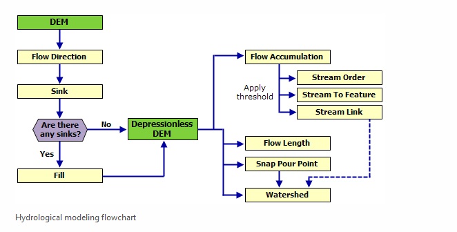
Source: Deriving runoff characteristics—Help | ArcGIS for Desktop
An overview of the Hydrology toolset—Help | ArcGIS for Desktop
How Watershed works—Help | ArcGIS for Desktop
Caveat - before one can derive the Watershed, one typically needs to do preparation on the Digital Elevation Model (DEM) to make it hydrologically correct. The DEM will need to be processed to make it "Depressionless". If not, there will be all sorts of wierdness.
Creating a depressionless DEM—Help | ArcGIS for Desktop
Chris Donohue, GISP
- Mark as New
- Bookmark
- Subscribe
- Mute
- Subscribe to RSS Feed
- Permalink
- Report Inappropriate Content
I have gone through this process already and unfortunately there is nowhere to use custom points to delineate an upstream watershed boundary from that point.
- Mark as New
- Bookmark
- Subscribe
- Mute
- Subscribe to RSS Feed
- Permalink
- Report Inappropriate Content
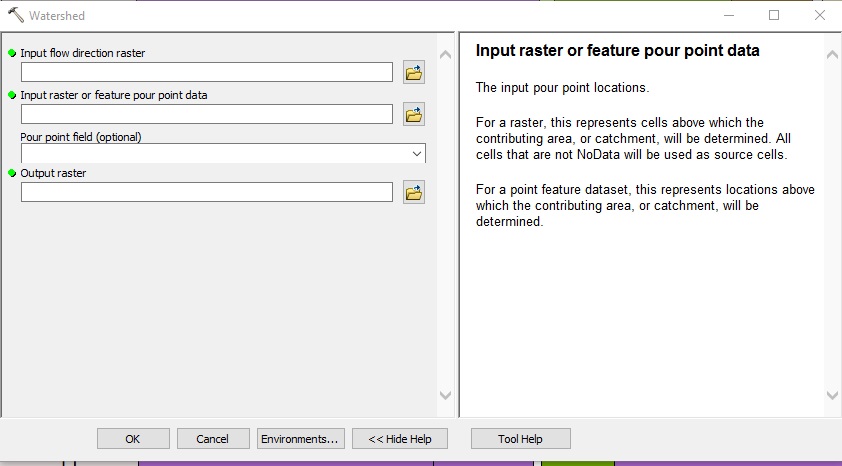
Can you elaborate on what you mean by "custom points"?
Typically the Watershed tool is run based on the Pour Point, which represents the point to derive the watershed upstream from. As an input, the Pour Point is most commonly a point in a point feature class.
The outlet, or pour point, is the point on the surface at which water flows out of an area. It is the lowest point along the boundary of a watershed.
How Watershed works—Help | ArcGIS Desktop
So in the Watershed Tool, for "Input raster or feature pour point data" one typically uses a point feature class with the pour point.
Chris Donohue, GISP
- Mark as New
- Bookmark
- Subscribe
- Mute
- Subscribe to RSS Feed
- Permalink
- Report Inappropriate Content
By custom points I just simply mean a sample location taken by me. A lat long coordinate. I want to determine the upstream watershed that contributes to all water in that watershed at that point. Is there any way to do this?
- Mark as New
- Bookmark
- Subscribe
- Mute
- Subscribe to RSS Feed
- Permalink
- Report Inappropriate Content
I have the DEM model for the study area. I have gone through the step by step process of creating all of the various shapefiles in your flow chart above for the hydrology toolset and the arc hydro toolbox but I can't find any information on how to use your own points to delineate the watershed boundary. I need to only have the contributing area above this point for my analyses. Since this is possible in streamstats it has to be somehow possible using either archydro or this hydrology toolset. I tried using the point in the pour point feature as you suggested but this came out as just a white blank raster. I also tried using the tutorials on this website for the arc hydro toolbox Dr. Venkatesh Merwade's web page but I can't get the catchment polygon processing step to work using archydro. I've been trying to work on this for the past three days and nothing at all has worked out. If anyone could give any insight on to how to do this it would be greatly appreciated, it seems like such a simple thing that needs to be done but a whole lot of steps to get there.
- Mark as New
- Bookmark
- Subscribe
- Mute
- Subscribe to RSS Feed
- Permalink
- Report Inappropriate Content
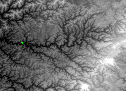
Snaps pour points to the cell of highest flow accumulation within a specified distance.Meaning that you will need to have completed the bits upto and including the flow accumulation, hopefully picking a point that is on the raster's apparent stream network, otherwise you won't get results that are 'expected'
- Mark as New
- Bookmark
- Subscribe
- Mute
- Subscribe to RSS Feed
- Permalink
- Report Inappropriate Content
If the suggestion by Dan Patterson to use Snap Pour Point didn't pan out, I'd go back and carefully review the project data. There can be many potential things that can go awry with this type of analysis. Here's some things to look into:
- Is the data projected? It is strongly suggested that all the data be in the same projection/coordinate system.
- Instead of using shapefiles, try using File Geodatabase feature classes in a Feature Dataset with the project/coordinate system set. This will help keep the data consistent.
- Manually review all the outputs of each process step and see if they make sense. It just takes one output being done incorrectly to throw the whole process, and for some of the outputs it will not immediately be obvious if it is wrong.
- Note that some of the tools in this process use thresholds. It may take experimenting with various threshold values to find one that most effectively reflects the situation.
- For example, if the data does seem correct, run the Basin (Spatial Analyst) geoprocessing tool on the Flow Direction Raster. If the resulting basins are correctly being shown, then that suggests the Pour Point is probably the issue. However, if the Basins are not correctly delineated, then the data processing up to that step is off in some way.
- Also, my general advice to pass on regarding the hydrologic tools and the iteration/troubleshooting/reviewing is that what you are experiencing is pretty typical. Even after having done this process many times, I still find it is an iterative process that takes some time and many runs, and far less often an immediate "1-2-3 OK done" process.
Chris Donohue, GISP